Metamora, Ohio
Metamora is a village in Fulton County, Ohio, United States. The population was 627 at the 2010 census.
Metamora, Ohio | |
|---|---|
 | |
 Location of Metamora, Ohio | |
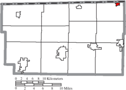 Location of Metamora in Fulton County | |
| Coordinates: 41°42′40″N 83°54′37″W | |
| Country | United States |
| State | Ohio |
| County | Fulton |
| Township | Amboy |
| Government | |
| • Mayor | Kenneth T. Wysong |
| Area | |
| • Total | 0.84 sq mi (2.18 km2) |
| • Land | 0.83 sq mi (2.15 km2) |
| • Water | 0.01 sq mi (0.03 km2) |
| Elevation | 722 ft (220 m) |
| Population | |
| • Total | 627 |
| • Estimate (2019[4]) | 608 |
| • Density | 755.4/sq mi (291.7/km2) |
| Time zone | UTC-5 (Eastern (EST)) |
| • Summer (DST) | UTC-4 (EDT) |
| ZIP code | 43540 |
| Area code(s) | 419 |
| FIPS code | 39-49238[5] |
| GNIS feature ID | 1048968[2] |
History
The first settlement at Metamora was made in the 1830s.[6] A post office called Metamora has been in operation since 1841.[7]
The name of Metamora is from a play titled: Metamora, Last of the Wampanoags. Author Edwin Forrest-Tom Kelleher. This Play led four new Midwestern towns—in Ohio, Indiana, Illinois, and Michigan—to adopt the name Metamora.[8]
Geography
Metamora (also known as Amboy) is located at 41°42′40″N 83°54′37″W (41.711239, -83.910259).[9]
According to the United States Census Bureau, the village has a total area of 0.84 square miles (2.18 km2), of which 0.83 square miles (2.15 km2) is land and 0.01 square miles (0.03 km2) is water.[1]
Demographics
| Historical population | |||
|---|---|---|---|
| Census | Pop. | %± | |
| 1880 | 108 | — | |
| 1900 | 263 | — | |
| 1910 | 475 | 80.6% | |
| 1920 | 484 | 1.9% | |
| 1930 | 552 | 14.0% | |
| 1940 | 490 | −11.2% | |
| 1950 | 532 | 8.6% | |
| 1960 | 598 | 12.4% | |
| 1970 | 594 | −0.7% | |
| 1980 | 556 | −6.4% | |
| 1990 | 543 | −2.3% | |
| 2000 | 563 | 3.7% | |
| 2010 | 627 | 11.4% | |
| Est. 2019 | 608 | [4] | −3.0% |
| U.S. Decennial Census[10] | |||
2010 census
As of the census[3] of 2010, there were 627 people, 221 households, and 168 families living in the village. The population density was 755.4 inhabitants per square mile (291.7/km2). There were 234 housing units at an average density of 281.9 per square mile (108.8/km2). The racial makeup of the village was 99.2% White, 0.2% Native American, and 0.6% from two or more races. Hispanic or Latino of any race were 2.2% of the population.
There were 221 households of which 42.1% had children under the age of 18 living with them, 59.7% were married couples living together, 10.9% had a female householder with no husband present, 5.4% had a male householder with no wife present, and 24.0% were non-families. 20.8% of all households were made up of individuals and 6.8% had someone living alone who was 65 years of age or older. The average household size was 2.84 and the average family size was 3.32.
The median age in the village was 36.9 years. 29.8% of residents were under the age of 18; 8.2% were between the ages of 18 and 24; 24.6% were from 25 to 44; 26.6% were from 45 to 64; and 10.8% were 65 years of age or older. The gender makeup of the village was 49.3% male and 50.7% female.
2000 census
As of the census[5] of 2000, there were 563 people, 200 households, and 149 families living in the village. The population density was 1,323.5 people per square mile (505.5/km²). There were 205 housing units at an average density of 481.9 per square mile (184.1/km²). The racial makeup of the village was 97.87% White, 0.53% African American, 0.18% Native American, 0.71% from other races, and 0.71% from two or more races. Hispanic or Latino of any race were 3.37% of the population.
There were 200 households out of which 42.5% had children under the age of 18 living with them, 54.5% were married couples living together, 12.0% had a female householder with no husband present, and 25.5% were non-families. 22.0% of all households were made up of individuals and 10.5% had someone living alone who was 65 years of age or older. The average household size was 2.82 and the average family size was 3.32.
In the village, the population was spread out with 33.0% under the age of 18, 5.7% from 18 to 24, 30.2% from 25 to 44, 20.4% from 45 to 64, and 10.7% who were 65 years of age or older. The median age was 34 years. For every 100 females there were 101.8 males. For every 100 females age 18 and over, there were 96.4 males.
The median income for a household in the village was $47,750, and the median income for a family was $53,661. Males had a median income of $33,000 versus $24,688 for females. The per capita income for the village was $16,387. About 5.8% of families and 8.5% of the population were below the poverty line, including 11.7% of those under age 18 and 23.5% of those age 65 or over.
Education
Evergreen Local School District administers three schools: Evergreen Elementary School, Evergreen Middle School, and Evergreen High School.[11] The Evergreen Community Library is the village's lending library.[12]
References
- "US Gazetteer files 2010". United States Census Bureau. Archived from the original on 2012-01-25. Retrieved 2013-01-06.
- "US Board on Geographic Names". United States Geological Survey. 2007-10-25. Retrieved 2008-01-31.
- "U.S. Census website". United States Census Bureau. Retrieved 2013-01-06.
- "Population and Housing Unit Estimates". Retrieved May 21, 2020.
- "U.S. Census website". United States Census Bureau. Retrieved 2008-01-31.
- Reighard, Frank H. (1920). A Standard History of Fulton County, Ohio (Volume 1). Lewis Publishing Company. p. 316.
- "Fulton County". Jim Forte Postal History. Retrieved 25 January 2016.
- http://resources.osv.org/explore_learn/document_viewer.php?DocID=2068
- "US Gazetteer files: 2010, 2000, and 1990". United States Census Bureau. 2011-02-12. Retrieved 2011-04-23.
- "Census of Population and Housing". Census.gov. Retrieved June 4, 2015.
- "Buildings". Evergreen Local School District. Retrieved 25 February 2018.
- "Homepage". Evergreen Community Library. Retrieved 25 February 2018.
Municipalities and communities of Fulton County, Ohio, United States | ||
|---|---|---|
| City |  Map of Ohio highlighting Fulton County | |
| Villages | ||
| Townships | ||
| CDPs | ||
| Unincorporated communities | ||
| Ghost towns | ||
| Footnotes | ‡This populated place also has portions in an adjacent county or counties | |
| Authority control |
|
|---|