Mayer, Arizona
Mayer is a census-designated place (CDP) in Yavapai County, Arizona, United States. The population was 1,408 at the 2000 census. Mayer includes three sites listed on the National Register of Historic Places: Mayer Apartments, Mayer Business Block, and Mayer Red Brick Schoolhouse.
Mayer, Arizona | |
|---|---|
CDP | |
-Mayer_welcome_sign.jpg) "Welcome to Mayer, Arizona" | |
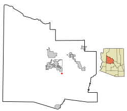 Location in Yavapai County and the state of Arizona | |
 Mayer, Arizona Location in the United States | |
| Coordinates: 34°25′9″N 112°14′59″W | |
| Country | United States |
| State | Arizona |
| County | Yavapai |
| Area | |
| • Total | 20.08 sq mi (52.00 km2) |
| • Land | 20.08 sq mi (52.00 km2) |
| • Water | 0.00 sq mi (0.00 km2) |
| Elevation | 4,415 ft (1,346 m) |
| Population (2010) | |
| • Total | 1,497 |
| • Estimate (2016)[2] | N/A |
| Time zone | UTC-7 (MST) |
| ZIP code | 86333 |
| Area code(s) | 928 |
| FIPS code | 04-45180 |
| GNIS feature ID | 0031605 |
History
The place was originally called Wi:kidoʼyoʼ in Yavapai.[3] From May to June 1942, 245 Japanese Americans were confined at the Mayer Assembly Center, one of 17 temporary detention camps built to hold Japanese Americans removed from the West Coast after the U.S. entered World War II. The 69 families were mostly from Maricopa County's Salt River Valley area, and lived in military-style barracks on the converted Civilian Conservation Corps camp for just under a month before being transferred to the more permanent and isolated internment camp at Poston, Arizona.[4]
Geography
Mayer is located at 34°25′9″N 112°14′59″W (34.419154, −112.249779).[5]
According to the United States Census Bureau, the CDP has a total area of 20.1 square miles (52 km2), all of it land.
Climate
According to the Köppen Climate Classification system, Mayer has a semi-arid climate, abbreviated "BSk" on climate maps.[6]
Demographics
| Historical population | |||
|---|---|---|---|
| Census | Pop. | %± | |
| 2000 | 1,408 | — | |
| 2010 | 1,497 | 6.3% | |
| U.S. Decennial Census[7] | |||
At the 2000 census there were 1,408 people, 585 households, and 379 families living in the CDP. The population density was 70.2 people per square mile (27.1/km²). There were 714 housing units at an average density of 35.6 per square mile (13.7/km²). The racial makeup of the CDP was 93.82% White, 1.21% Native American, 0.21% Asian, 2.63% from other races, and 2.13% from two or more races. 8.95% of the population were Hispanic or Latino of any race.[8] Of the 585 households 25.5% had children under the age of 18 living with them, 51.6% were married couples living together, 8.2% had a female householder with no husband present, and 35.2% were non-families. 27.5% of households were one person and 13.3% were one person aged 65 or older. The average household size was 2.41 and the average family size was 2.94.
The age distribution was 23.7% under the age of 18, 5.8% from 18 to 24, 23.4% from 25 to 44, 28.3% from 45 to 64, and 19.0% 65 or older. The median age was 44 years. For every 100 females, there were 99.2 males. For every 100 females age 18 and over, there were 97.6 males.
The median household income was $28,412 and the median family income was $33,988. Males had a median income of $38,304 versus $21,417 for females. The per capita income for the CDP was $14,297. About 14.1% of families and 19.1% of the population were below the poverty line, including 13.0% of those under age 18 and 16.9% of those age 65 or over.
National Register of Historic Places
The following pictured properties in Mayer are listed in the National Register of Historic Places:[9]
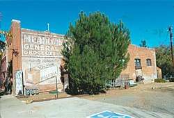
-Historic_Mayer_Business_Block-1902.jpg) Historic Mayer Business Block.
Historic Mayer Business Block.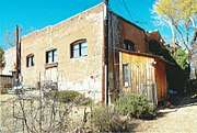 Rear view of the Mayer General Market Store.
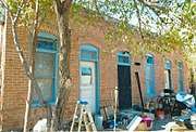 Mayer Apartment #1.
 Mayer Apartment #2.
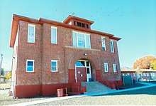 Mayer Red Brick Schoolhouse.
References
- "2016 U.S. Gazetteer Files". United States Census Bureau. Retrieved July 18, 2017.
- "Population and Housing Unit Estimates". Retrieved June 9, 2017.
- http://www.ansac.az.gov/UserFiles/PDF/10132015/C028_SLD-AG%20Supplement%202/298%20-%20Gifford,%20Northeastern%20and%20Western%20Yavapai.pdf
- Masumoto, Marie. "Mayer (detention facility)" Densho Encyclopedia. Retrieved June 23, 2014.
- "US Gazetteer files: 2010, 2000, and 1990". United States Census Bureau. February 12, 2011. Retrieved April 23, 2011.
- Climate Summary for Mayer, Arizona
- "Census of Population and Housing". Census.gov. Retrieved June 4, 2016.
- "U.S. Census website". United States Census Bureau. Retrieved January 31, 2008.
- National Register of Historic Properties: Yavapai County
External links
![]()

| Authority control |
|
|---|