Mapleville, Maryland
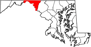
Mapleville is an unincorporated community and census-designated place in eastern Washington County, Maryland, United States. Its population was 238 as of the 2010 census.[1] It is officially a part of the Hagerstown Metropolitan Area.
Mapleville, Maryland | |
|---|---|
 Boonsboro Pike, Mapleville | |
 Mapleville  Mapleville | |
| Coordinates: 39°32′20″N 77°38′51″W | |
| Country | United States |
| State | Maryland |
| County | Washington |
| Area | |
| • Total | 0.403 sq mi (1.04 km2) |
| • Land | 0.403 sq mi (1.04 km2) |
| • Water | 0 sq mi (0 km2) |
| Elevation | 610 ft (190 m) |
| Population | |
| • Total | 238 |
| • Density | 590/sq mi (230/km2) |
| Time zone | UTC−5 (Eastern (EST)) |
| • Summer (DST) | UTC−4 (EDT) |
| Area code(s) | 240 & 301 |
| GNIS feature ID | 590735[2] |
Mapleville lies along MD Route 66, known locally as the Mapleville Road, north of Boonsboro and just south of the community of San Mar. Route 66 links the towns of Boonsboro and Smithsburg, and provides local residents with access to nearby U.S. Route 40 and Interstate 70, making the main road along which the community is settled well-traveled. Short Hill, a lesser arm of the Blue Ridge's South Mountain, lies directly to the east of Mapleville; Greenbrier State Park & Lake are located between the hill and the range's principal ridge.
Geography
According to the U.S. Census Bureau, the community has an area of 0.403 square miles (1.04 km2), all land.[1]
References
- "2010 Census Gazetteer Files - Places: Maryland". U.S. Census Bureau. Retrieved February 25, 2017.
- "Mapleville". Geographic Names Information System. United States Geological Survey.