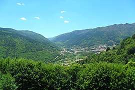
Manteigas
Manteigas (Portuguese pronunciation: [mɐ̃ˈtɐjɣɐʃ] (![]()
Manteigas | |
|---|---|
 | |
 Flag  Coat of arms | |
 | |
| Coordinates: 40°24′N 7°32′W | |
| Country | |
| Region | Centro |
| Intermunic. comm. | Beiras e Serra da Estrela |
| District | Guarda |
| Parishes | 4 |
| Government | |
| • President | Esmeraldo Carvalhinho (PS) |
| Area | |
| • Total | 121.98 km2 (47.10 sq mi) |
| Population (2011) | |
| • Total | 3,430 |
| • Density | 28/km2 (73/sq mi) |
| Time zone | UTC±00:00 (WET) |
| • Summer (DST) | UTC+01:00 (WEST) |
| Local holiday | March 4 |
| Website | http://www.cm-manteigas.pt |
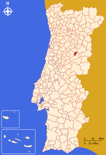
The municipality is located in Guarda District; in Centro Region and Beira Interior Norte Subregion. It is located in the Serra da Estrela Mountains, the highest elevation in mainland Portugal. Cities nearby: Guarda, Seia, Gouveia and Covilhã.
The municipal holiday is March 4.
Parishes
Administratively, the municipality is divided into 4 civil parishes (freguesias):[3]
- Sameiro
- Santa Maria (Town of Manteigas)
- São Pedro (Town of Manteigas)
- Vale de Amoreira
See also
References
- Instituto Nacional de Estatística
- "Áreas das freguesias, concelhos, distritos e país". Archived from the original on 2018-11-05. Retrieved 2018-11-05.
- Diário da República. "Law nr. 11-A/2013, page 552 67" (pdf) (in Portuguese). Retrieved 28 July 2014.
This article is issued from Wikipedia. The text is licensed under Creative Commons - Attribution - Sharealike. Additional terms may apply for the media files.