Manicaland Province
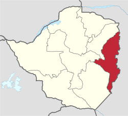
Manicaland is a province in eastern Zimbabwe. After Harare Province, it is the country's second-most populous province, with a population of 1.75 million, as of the 2012 census. After Harare and Bulawayo provinces, it is Zimbabwe's third-most densely populated province. Manicaland was one of five original provinces established in Southern Rhodesia in the early colonial period.[3] The province is divided into ten administrative subdivisions of seven rural districts and three towns/councils, including the provincial capital, Mutare. The name Manicaland is derived from the province's largest ethnic group, the Manyika, a Shona subgroup who speak a distinct Shona dialect, Manyika.
Manicaland | |
|---|---|
 Manicaland, Province of Zimbabwe | |
| Country | Zimbabwe |
| Capital | Mutare |
| Area | |
| • Total | 36,459 km2 (14,077 sq mi) |
| Highest elevation | 2,592 m (8,504 ft) |
| Population (2012) | |
| • Total | 1,752,698[1] |
| HDI (2018) | 0.525[2] low · 9th |
Manicaland is bordered by Mashonaland East Province to the northwest, Midlands Province to the west, Masvingo Province to the southwest, and Mozambique to the east. It has an area of 36,459 square kilometres (14,077 sq mi),[4] equal to 9.28% of the total area of Zimbabwe. It is the sixth-largest in area of Zimbabwe's ten provinces. Its economy is largely centered around industry and agriculture, particularly manufacturing, diamond and gold mining, timber, tea and coffee plantations, and tourism.[5] In recent years, Manicaland's economy has declined as manufacturing firms and mines continue to fold,[5] and the province now lags behind other Zimbabwean provinces economically and developmentally.[6]
Etymology
The name Manicaland derives from the fact that the area has been occupied in recent history by the Manyika people. The Manyika are a Shona sub-tribal grouping with their own language variant, the Manyika language.
Geography
The province is bordered by Mashonaland East Province to the north, Midlands Province to the west, Masvingo Province to the south and southwest, and the Republic of Mozambique to the east.[7] The provincial capital, Mutare (pop:184,205),[8] lies approximately 265 kilometres (165 mi), by road, southeast of Harare, the capital of Zimbabwe and the largest city in that country.[9]
The Eastern Highlands run along the eastern edge of Manicaland. The highlands are made up of several mountain ranges and include Mount Nyangani, Zimbabwe's highest peak.
The northern part of Manicaland is drained northwards by tributaries of the Zambezi River, including the Gairezi and the Nyangombe. The central and southern portions of the province are drained southwards by the Save River and its tributaries, including the Odzi River. Some areas along the province's eastern edge, including Honde Valley, Burma Valley, and eastern Chimanimani and Chipinge districts, drain eastwards into the Pungwe and Buzi rivers.
Districts
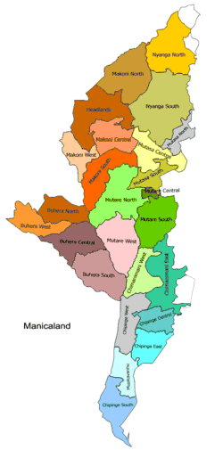
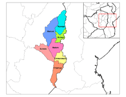
The province is subdivided into seven rural districts and three town/councils:
- Buhera District
- Chimanimani District
- Chipinge District
- Makoni District
- Mutare District (in the center)
- Mutasa District
- Nyanga District (in the northeast of the province)
- Mutare City Council
- Chipinge Town Council
- Rusape Town Council
Demographics
| Historical population | ||
|---|---|---|
| Year | Pop. | ±% |
| 1992 | 1,537,676 | — |
| 2002 | 1,568,930 | +2.0% |
| 2012 | 1,752,698 | +11.7% |
| Source: Zimbabwe National Statistics Agency (ZIMSTAT) | ||
Manicaland is the second most populated province in Zimbabwe. It has a population of about 1,755,000 which constitutes about 13.5% of the country's total population.
The people of Manicaland speak Shona, but different districts have own sub-dialects. For example, Mutasa District uses the Manyika sub-dialect. In Makoni District, the people use the Maungwe dialect, Chipinge, the Ndau and Mutare, the Bocha and Jindwi dialects.
A great number of the population practise their own traditional way of worshipping, but many also practice Christianity (about 65%). The majority falling under the traditional churches: Methodist Church, Seventh-day Adventist Church, the Anglican Church and the Roman Catholic Church. The Pentecostal churches have large followings in the urban areas of Mutare and a few other growth points. Some gatherings fall under the Apostolic Churches, with a notably higher proportion of the Apostolic followers in Mutare and Buhera district. Polygamy is quite prevalent among church members.
Schools
Manicaland boasts of some of the best performing schools in the country. Schools such as St Augastines (Tsambe), St Faith's School, Rusape (Fisco-'Madetere') (Currently the best performing school 2012 at 'O' level and 'A' level in Zimbabwe), Nyanga High School, Marist Brothers, St Marys, Bonda High, Emmanuel High, Kriste Mambo, Mutare Boys' High School, Mutare Girls High (The Shumbas), St Dominics Mutare, Marange High, Hartzell High, Lydia Chimonyo, Sakubva High, Dangamvura High. These have produced exceptional results over the years and a great number of academics renowned internationally.
The privately run Africa University provides some relief (albeit to a lesser extent), but it simply cannot absorb the huge numbers of school leavers with high grades.
In general, there is a school within a 5 kilometres (3.1 mi) radius across Manicaland. There are numerous primary and secondary schools scattered across the province. The distribution of schools by district is shown in the table below.
| District | Primary | Secondary |
|---|---|---|
| Buhera | 140 | 55 |
| Chimanimani | 68 | 24 |
| Chipinge | 125 | 40 |
| Makoni | 170 | 60 |
| Mutare | 172 | 67 |
| Mutasa | 72 | 27 |
| Nyanga | 75 | 25 |
| Total | 822 | 298 |
Places of interest
- Troutbeck, Manicaland
- Nyanga
- Marange diamond fields
- Vumba
- Chimanimani
- Hot Springs
- Osborne Dam
- Smallbridge Dam
- Birchenough Bridge
- Mutarazi Falls and "Mudhebdheb" suspension bridges
References
- "Population Census National Report 2012" (PDF). Zimbabwe National Statistics. Archived from the original (PDF) on 10 January 2017. Retrieved 9 April 2017.
- "Sub-national HDI - Area Database - Global Data Lab". hdi.globaldatalab.org. Retrieved 2018-09-13.
- Chakamwe, Chakamwe (2014-05-01). "Changing the names of provinces". The Patriot. Retrieved 2018-06-15.
- Surface Area of Manicaland District Archived 2013-12-17 at the Wayback Machine
- Matimaire, Kenneth (2017-03-23). "Manicaland industries collapse". The Financial Gazette. Retrieved 2018-06-15.
- Zimunya, Itai (2012-11-18). "Manicaland is also for devolution". The Standard. Retrieved 2018-06-15.
- Map of Provinces of Zimbabwe
- Estimated Population of Mutare In 2004
- Road Distance Between Harare And Mutare With Map
- Manicaland Regional Education Office, 2004.
External links
| Wikimedia Commons has media related to Manicaland Province. |
- Energy Sector Background for Manicaland Province
- Manicaland Publicity Association
- The Catholic Church In Manicaland 1896-1996
| Authority control |
|
|---|