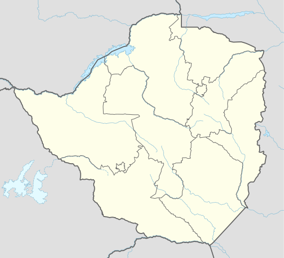
Gweru
Gweru (named Gwelo until 1982) is a city in central Zimbabwe. Located near the geographical centre of the country, it is the capital of Midlands Province. Originally an area known to the indigenous Ndebele as "The Steep Place" because of the Gweru River's high banks, in 1894 it became the site of a military outpost established by Leander Starr Jameson.[2] In 1914 it attained municipal status, and in 1971 it became a city.
Gweru | |
|---|---|
 | |
 Flag .png) Coat of arms | |
| Motto(s): Progress | |
 Gweru | |
| Coordinates: 19°27′41″S 29°48′08″E | |
| Country | Zimbabwe |
| Province | Midlands |
| Founded | 1894 |
| Incorporated (town) | 1914 |
| Incorporated (city) | 1971 |
| Elevation | 1,424 m (4,672 ft) |
| Population (2012[1]) | |
| • Total | 157,865 |
| Time zone | UTC+2 (CAT) |
| Climate | Cwb |
| Website | https://gwerucitycouncilsite.wordpress.com/ |
The city has a population of 141,862 as of 2013. Gweru is known for vibrant farming activities in beef cattle, crop farming, and commercial gardening of crops for the export market.[3] It is also home to a number of colleges and universities, most prominently Midlands State University and Mkoba Teachers College.
The city was nicknamed City of Progress.
History
Gweru used to be named Gwelo.
Geography
The geographical coordinates for Gweru Urban are 19° 27' 0'' South and 29° 49' 0'' East. This places Gweru at the centre of Zimbabwe. The area coverage is almost 46 166 km². The city is built alongside Bulawayo-Harare railway and the road near the railway spur to Mabuto.
Climate
| Climate data for Gweru (1961–1990) | |||||||||||||
|---|---|---|---|---|---|---|---|---|---|---|---|---|---|
| Month | Jan | Feb | Mar | Apr | May | Jun | Jul | Aug | Sep | Oct | Nov | Dec | Year |
| Average high °C (°F) | 26.3 (79.3) |
25.8 (78.4) |
25.8 (78.4) |
24.7 (76.5) |
22.9 (73.2) |
20.6 (69.1) |
20.5 (68.9) |
23.3 (73.9) |
26.8 (80.2) |
28.3 (82.9) |
27.4 (81.3) |
26.3 (79.3) |
24.9 (76.8) |
| Average low °C (°F) | 15.3 (59.5) |
15.1 (59.2) |
13.8 (56.8) |
11.3 (52.3) |
7.6 (45.7) |
4.9 (40.8) |
4.5 (40.1) |
6.5 (43.7) |
10.0 (50.0) |
13.1 (55.6) |
14.5 (58.1) |
15.1 (59.2) |
11.0 (51.8) |
| Average rainfall mm (inches) | 139.1 (5.48) |
124.8 (4.91) |
55.9 (2.20) |
29.0 (1.14) |
7.7 (0.30) |
1.9 (0.07) |
1.0 (0.04) |
1.9 (0.07) |
9.3 (0.37) |
35.1 (1.38) |
96.2 (3.79) |
159.4 (6.28) |
661.3 (26.04) |
| Average rainy days | 12 | 10 | 7 | 3 | 1 | 1 | 0 | 0 | 1 | 4 | 9 | 12 | 60 |
| Source: World Meteorological Organization[4] | |||||||||||||
Demographics
Nature and wildlife
In and around Gweru there are attractive places, some are man-made and some are natural. There is:
- Antelope Park
- White Waters
- Insukamini Ruins
| Historical population | ||
|---|---|---|
| Year | Pop. | ±% |
| 1936 | 2,165 | — |
| 1941 | 5,100 | +135.6% |
| 1946 | 7,237 | +41.9% |
| 1951 | 9,800 | +35.4% |
| 1960 | 27,290 | +178.5% |
| 1969 | 36,840 | +35.0% |
| 1974 | 51,000 | +38.4% |
| 1978 | 66,000 | +29.4% |
| 1982 | 78,918 | +19.6% |
| 1992 | 128,037 | +62.2% |
| 2002 | 141,260 | +10.3% |
| 2012 | 157,865 | +11.8% |
Economy
Gweru is known for vibrant farming activities in beef cattle, crop farming, and commercial gardening of crops for the export market.The country`s oldest shoe manufacturer Bata Shoe Company and the Military and Aviation Museums are also some key features Gweru is well known for.[3]
Culture
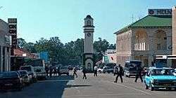
The Boggie Clock Tower, located at the intersection of Main Street and Robert Mugabe Way, was built in 1928 in memory of Major William James Boggie. The clock tower is one of the city's most famous landmarks.[2]
The Nalatale and Danangombe archaeological sites lie nearby, the former known for its patterned brickwork, the latter for its Portuguese remains. The remains at these sites date back to as early as the Torwa state during the 17th century, the most substantial being a four hundred-year-old stone wall decorated with motifs known to the tradition of stone-building in Zimbabwe. The surrounding area has rich deposits of gold, chrome, iron, asbestos and platinum and supports several mines.[2]
Tourism
The main hotel in the city is the Midlands Hotel, which was opened in 1927 by the Meikles brothers. This hotel was to be demolished but after many protests by the population it was saved. Another important hotel is the Chitukuko (formerly the Hotel Cecil), located in the downtown area of the city. Both hotels were owned by Patrick Kombayi, a former mayor. The Fairmile Motel is just one mile from the city center on the Bulawayo highway .
Sports and stadia
Soccer
- Chapungu Football Club
Chapungu F.C team was nicknamed Waru Waru and the team is currently playing in Zimbabwe Premier League Soccer League. Its home is Ascot Stadium.
There is also Gweru Sports club which has playgrounds for rugby, bowling and cricket.
Government and politics
Education
Primary education
Group A
- Cecil John Rhodes School
- Lundi Park School
- Riverside School
- Stanley School
- Anderson Adventist Primary School (private)
- Lingfield Academy (private)
- Midlands Christian School (private)
Group B
- Airforce Thornhill Primary School
- Bata School
- Bumburwi School
- Chikumbiro School
- Matongo School
- Mkoba 4 Primary School
- Mpumelelo Primary School
- Muwunga School
- Sandara School
- Senga Primary School
- Takunda Primary School
- Takwirira Primary School
- St. Michael's Primary School (Catholic)
- St. Paul's School (Catholic)
Secondary education
Group A
- Chaplin High School
- Guinea Fowl High School
- Nashville Secondary School
- Thornhill High School
- Anderson Adventist High School (private)
- Lingfield Christian Academy (private)
- Midlands Christian College (private)
Group B
- Ascot Secondary School
- Fletcher High School
- Mambo High School
- Matinunura High school
- Mkoba 1 High School
- Mkoba 3 High School
- Senka Secondary School
Tertiary education
- Ambassador College
- Central Africa Correspondence College
- Commercial Studies Centre
- Educare College
- Gweru Polytechnic Institute
- Herentals College
- International Correspondence Schools
- Kaguvi National Technical College
- Mkoba Teachers College
- Midlands Christian Training Centre
- Midlands State University
- Rapid Results College
- Senka Technical Training Centre
- Solars College
- TopFlight Secretarial College
- Zimbabwe Distance Education College
- Zimbabwe Open University
- Mount Hermon Theological Seminary
Defunct colleges and universities
- Midlands College of Commerce (closed 1994)
Media
Gweru's local newspaper, The Gweru Times,once ceased publishing in 2015 but now operational.
Industry
In Gweru there are big companies that are still operating and are still capable of employing hundreds of employees. Not forgetting future big companies which are SMEs are also listed. These companies are in and around Gweru. Below are the list of companies grouped according to size and type of the industry. Some of the Companies in Gweru: Bata Shoe Company, ZimGlass, ZimCast,ZimAlloys, Delta Corporation, Anchor Yeast, Midlands State University.
Transportation
Railway
Railways arrived in Gwelo (Gweru) in 1902. National Railways of Zimbabwe have the country's largest marshalling yard, Dabuka, on the south side of Gweru. Dabuka plays a pivotal role in rail movement in the country as it is the central hub of the rail links to Mozambique in the east, South Africa in the south and Botswana and Namibia in the south west, lying on the Beira–Bulawayo railway.[5]
Roads
As a central city (hub), it has direct links to all the other cities and towns of Zimbabwe. It is 164 km from Bulawayo, 183 km from Masvingo, 471 km from Beitbridge, and 275 km from Harare.
Road names used are by destination only, for example the Harare-Bulawayo Road. There are only mainroads, no highways or freeways.[6]
Notable people
- Brendan Ashby, Olympic swimmer
- Patient Charumbira, cricketer
- Shimmer Chinodya, writer
- Edmore Chirambadare, footballer
- Gerald B. Clarke, Rhodesian politician
- Malcolm Grainger, cricketer
- Gregg Haakonsen, cricketer
- Mandy Loots, Olympic swimmer
- Orlando Lourenco, tennis player
- Paddington Mhondoro, cricketer
- Energy Murambadoro, footballer
- Kudakwashe Musharu, footballer
- Luther Mutyambizi, cricketer
- Christopher Muzvuru, Irish Guards piper
- Welshman Ncube, politician
- Rudolf Nyandoro, Roman Catholic bishop
- David Pocock, Australia international rugby union player (emigrated to Australia with his family at age 14)
- Ray Reed, racing driver
- Nkululeko Mkastos Sibanda, politician
- Alec Smith, Rhodesian Army chaplain, son of Ian Smith
- Thomas Sweswe, footballer
- Gary Teichmann, South Africa international rugby union player
Sister cities


See also
References
- "Census 2012 Provincial Report Midlands" (PDF). Zimbabwe National Statistics. Retrieved 25 December 2019.
- "Gweru - The City of Progress". www.mygweru.com. Retrieved 14 November 2016.
- "Gweru | Zimbabwe". Encyclopædia Britannica. Retrieved 14 November 2016.
- "World Weather Information Service – Gweru". World Meteorological Organization. Retrieved 25 October 2015.
- Mlambo, Alois (2003). "Bulawayo, Zimbabwe". In Paul Tiyambe Zeleza; Dickson Eyoh (eds.). Encyclopedia of Twentieth-Century African History. Routledge. ISBN 0415234794.
- The Automobile Association of Zimbabwe
- "Local Government International Bureau (LGIB) Database of "Twinning Towns". Archived from the original on 27 April 2007. Retrieved 16 April 2007.
- "Birmingham Sister City Commission". www.bhamwiki.com. Retrieved 25 April 2018.
Capital: Gweru | |
| Dams/Reservoirs |
|
| Rivers |
|
| Highways/Roads |
|
| Museums/Monuments | |
| Settlements |
|
| Health Centres |
|
| Irrgation Schemes |
|
| Education |
|
| Culture and sport |
|
| Notable People | |
| Constituencies |
|
| Industries | |
| Authority control |
|
|---|