Man, Ivory Coast
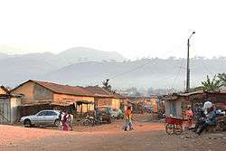
Man is a city in western Ivory Coast. It is the seat of both Montagnes District and Tonkpi Region. It is also a commune and the seat of and a sub-prefecture of Man Department. In the 2014 census, Man had a population of 188,704, making it the eighth-largest city in the country.
Man | |
|---|---|
City, sub-prefecture, and commune | |
 | |
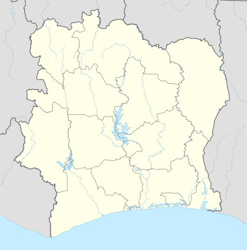 Man Location in Ivory Coast | |
| Coordinates: 7°24′N 7°33′W | |
| Country | |
| District | Montagnes |
| Region | Tonkpi |
| Department | Man |
| Population (2014)[1] | |
| • Total | 188,704 |
| Time zone | UTC+0 (GMT) |
History
In November 2002, during conflict between government and rebel forces, the former rebel group Mouvement patriotique de Côte d'Ivoire (MPCI) held Man and the towns of Danané, Toulepleu, and Bloléquin.[2]
Geography
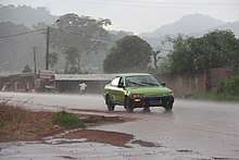
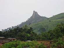
Man is part of Montagnes District and is an important market town lying between mountains, including Mount Toura and Mount Tonkoui (the two highest in the nation), and La Dent de Man, popular with hikers and most recently, rock climbers.[3]
Climate
Man has a tropical savanna climate (Köppen climate classification Aw).
| Climate data for Man, Ivory Coast | |||||||||||||
|---|---|---|---|---|---|---|---|---|---|---|---|---|---|
| Month | Jan | Feb | Mar | Apr | May | Jun | Jul | Aug | Sep | Oct | Nov | Dec | Year |
| Average high °C (°F) | 32.4 (90.3) |
33.5 (92.3) |
33.0 (91.4) |
31.9 (89.4) |
30.9 (87.6) |
29.3 (84.7) |
27.8 (82.0) |
27.6 (81.7) |
28.8 (83.8) |
29.8 (85.6) |
30.3 (86.5) |
30.6 (87.1) |
30.5 (86.9) |
| Daily mean °C (°F) | 23.7 (74.7) |
25.8 (78.4) |
26.7 (80.1) |
26.4 (79.5) |
26.0 (78.8) |
25.0 (77.0) |
24.0 (75.2) |
24.0 (75.2) |
24.6 (76.3) |
25.0 (77.0) |
24.9 (76.8) |
23.5 (74.3) |
25.0 (77.0) |
| Average low °C (°F) | 15.3 (59.5) |
18.8 (65.8) |
20.7 (69.3) |
21.3 (70.3) |
21.2 (70.2) |
21.0 (69.8) |
20.4 (68.7) |
20.6 (69.1) |
20.5 (68.9) |
20.4 (68.7) |
19.6 (67.3) |
16.7 (62.1) |
19.7 (67.5) |
| Average precipitation mm (inches) | 10.8 (0.43) |
43.4 (1.71) |
109.3 (4.30) |
152.8 (6.02) |
147.5 (5.81) |
183.7 (7.23) |
185.6 (7.31) |
273.6 (10.77) |
285.0 (11.22) |
134.5 (5.30) |
42.1 (1.66) |
19.5 (0.77) |
1,587.8 (62.51) |
| Mean monthly sunshine hours | 241.3 | 210.7 | 210.8 | 205.3 | 208.1 | 157.1 | 117.0 | 125.6 | 158.4 | 205.5 | 217.5 | 214.5 | 2,271.8 |
| Source: NOAA[4] | |||||||||||||
Economy
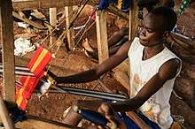
Man is an agricultural region, with many cocoa, rice, coffee, cassava, banana (plantain), and soybean plantations. The area is the largest producer of coffee in the Ivory Coast. It is the home of a UNICAFÉ (The National Coffee Manufacturer of Côte d'Ivoire) factory, and Nestlé operates several coffee plants in the area.[5] The central market of Man buys and a sells large variety of fabrics (Yacouba traditional clothes, so-called Boubou Yacouba), and an endless collection of Dan (Yacouba) masks.
The best known hotels are the "Hotel les Casacades", "Tanhotel", and "Hotel Beau Sejour". Those hotels are well-equipped with satellite TV, swimming pools, phone lines, and good service is provided.
Landmarks
The city is the home of the Roman Catholic Diocese of Man, with its cathedral at the Cathédrale Saint-Michel.
The main attractions around Man are La Cascade waterfall, a large rocky outcrop which overlooks the town known as the La Dent de Man (the tooth of Man), and the monkey forest.[6] La Cascade waterfall is situated at the west side of the town, and is surrounded by a bamboo forest, which is the habitat of many colorful dragonflies and a wide variety of butterflies. The monkey forest is a wooded area in which monkeys live; for a small fee tourists can persuade local residents to call the monkeys out of their forest habitat.
Villages
The twenty nine villages of the sub-prefecture of Man and their population in 2014 are:[7]
- Bantégouin (586)
- Bigouin (1 091)
- Blolé (2 784)
- Botongouiné (1 131)
- Dainé 2 (692)
- Dompleu (2 622)
- Gagouin (511)
- Godégouin (569)
- Gouakpalé (546)
- Gouimpleu 1 (971)
- Guianlé (1 421)
- Kassiapleu (1 148)
- Kpangouin 1 (1 018)
- Kpangouin 2 (1 409)
- Krikouma (1 205)
- Man (148 945)
- Petit Gbèpleu (648)
- Seupleu (849)
- Voungoué (1 764)
- Yébégouin (324)
- Zadépleu (463)
- Zélé (3 042)
- Biélé (1 533)
- Gbatongouin (1 205)
- Gueupleu (979)
- Kiélé (2 918)
- Lamapleu (1 132)
- Oulédépleu (718)
- Zérégouin (647)
References
- "Côte d'Ivoire". geohive.com. Archived from the original on 24 November 2015. Retrieved 5 December 2015.
- Higonnet, Etelle (2007). "My Heart is Cut": Sexual Violence by Rebels and Pro-government Forces in Côte D'Ivoire. Human Rights Watch. p. 24.
- West Africa. Lonely Planet. 2009. p. 281. ISBN 978-1-74104-821-6.
- "Man–Aero Climate Normals 1961–1990". National Oceanic and Atmospheric Administration. Retrieved December 21, 2015.
- Hamilton, Janice (1 January 2004). Ivory Coast in Pictures. Twenty-First Century Books. p. 60. ISBN 978-0-8225-1992-8.
- Auzias, Dominique; Labourdette, Jean-Paul (6 February 2013). Côte d'Ivoire 2013-2014 (in French). Petit Futé. p. 296. ISBN 2-7469-6176-8.
- "RGPH 2014, Répertoire des localités, Région Tonkpi" (PDF). ins.ci. Retrieved 5 August 2019.
External links
| Wikimedia Commons has media related to Man (Ivory Coast). |
| Wikivoyage has a travel guide for Man (Ivory Coast). |
- Ivorian rebels declare emergency; BBC; November 18, 2003
Regional seat: Man | ||
| Biankouma Department |  | |
| Danané Department | ||
| Man Department | ||
| Sipilou Department | ||
| Zouan-Hounien Department | ||
* also a commune | ||