Malubiting
Malubiting (Urdu: مالونیتنگ); also known as Malubiting West) is the second highest peak in the Haramosh Group of Mountains, a subrange of the Karakoram range of Pakistan.it is situated in the middle of Bilchar Dobani and Haramosh Peak in Haramosh valley Gilgit-Baltistan .
| Malubiting مالونیتنگ | |
|---|---|
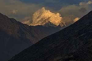 Malubiting in 2017 | |
| Highest point | |
| Elevation | 7,458 m (24,469 ft) Ranked 58th |
| Prominence | 2,193 m (7,195 ft) |
| Listing | Ultra |
| Coordinates | 36°02′20″N 74°54′03″E |
| Geography | |
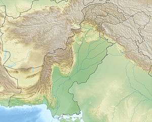 Malubiting مالونیتنگ Location in Pakistan | |
| Location | Gilgit–Baltistan, Pakistan |
| Parent range | Haramosh Group of mountains, Karakoram |
| Climbing | |
| First ascent | 1971 by K. Pirker, H. Schell, H. Schindlbacher, H. Sturm |
| Easiest route | glacier/snow/ice climb |
Location
Malubiting lies in the heart of the Haramosh Group of Mountains, which rise above the north bank of the Indus River Malubiting lies about 50 km east of Gilgit, the most important town in the region. Malubiting rises steeply over the Haramosh Jutial village (Phuparash) River to the southwest, while on the east the large Chogo Lungma Glacier starts on its slopes.
Climbing history
Malubiting was unsuccessfully attempted in 1955, 1959, 1968, 1969 and 1970 and 1971 before the first ascent in 1971. In that year an Austrian team led by Horst Schindlbacher reached the summit via the Northeast Ridge, ascending the North Peak and skirting the Central Peak on the way.
According to the Himalayan Index, there has been only one additional ascent, by a Swiss-German team in 1997, via the original route. (There may however have been other ascents that did not make it into the Index.)
Sources
- High Asia: An Illustrated History of the 7000 Metre Peaks by Jill Neate, ISBN 0-89886-238-8
- Orographical Sketch Map of the Karakoram by Jerzy Wala, 1990. Published by the Swiss Foundation for Alpine Research.
- Himalayan Index