Maipo River
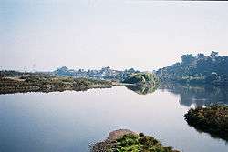
The Maipo River is the main river flowing through the Santiago Metropolitan Region and the Valparaiso Region of Chile. It is located just south of the capital of Santiago. The Mapocho River, which flows through central Santiago, is one of its tributaries. Its headwaters are on the west slope of Maipo volcano, in the Andes. The Maipo River is by far the major source of irrigation and potable water for the region.[1][2]
| Maipo River | |
|---|---|
 | |
| Location | |
| Country | Chile |
| Physical characteristics | |
| Mouth | Pacific Ocean |
⁃ location | San Antonio, Chile |
⁃ coordinates | 33°36′40″S 71°37′50″W |
| Length | 250 km (160 mi)[1] |
| Basin size | 15,304 km2 (5,909 sq mi)[1] |
| Discharge | |
| ⁃ average | 92.3 m3/s (3,260 cu ft/s) |
| Basin features | |
| Tributaries | |
| ⁃ right | El Volcán, Yeso and Colorado |
Course
In its upper course the river runs as an entrenched torrent through the Andes mountains. Here, it receives three major tributaries: the El Volcán River, the Yeso River and the Colorado River. After leaving the Andes, the Maipo flows through the valley that bears its name, which is one of the principal wine-producing region in Chile.[2] The Maipo River travels 250 km (160 mi) before emptying into the Pacific Ocean, near the locality of Llolleo, south of the port of San Antonio.
References
- Cuenca del río Maipo Archived 2012-02-12 at the Wayback Machine
- Cai, Ximing; Claudia Ringler; Mark W. Rosegrant (2006). Modeling Water Resources Management at the Basin Level: Methodology and Application to the Maipo River Basin. Washington DC: International Food Policy Research Institute. ISBN 978-0-89629-152-2.
External links
| Rivers |  | |
|---|---|---|
| Lakes | ||
| Rivers |
| |
|---|---|---|
| Lakes |
| |