Mageshima
Mageshima (馬毛島), is one of the Satsunan Islands, usually classed with the Ōsumi Islands belonging to Kagoshima Prefecture, Japan. It is administered by the city of Nishinoomote on Tanegashima.
| Native name: Japanese: 馬毛島 | |
|---|---|
Mageshima | |
 | |
| Geography | |
| Location | East China Sea |
| Coordinates | 30°44′29.9″N 130°51′16.9″E |
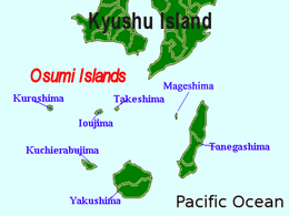
| Archipelago | Ōsumi Islands |
| Area | 8.2 km2 (3.2 sq mi) |
| Coastline | 16.5 km (10.25 mi) |
| Highest elevation | 71.7 m (235.2 ft) |
| Highest point | Takenokoshi |
| Administration | |
Japan | |
| Kagoshima Prefecture | |
| Demographics | |
| Population | 0 |
| Ethnic groups | Japanese |
Geography
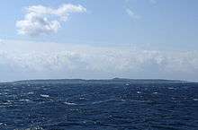
Mageshima is located 12 kilometres (6.5 nmi) west of Tanegashima. The island is of volcanic origin, and has an area of approximately 8.2 square kilometres (3.2 sq mi) with a circumference of 16.5 kilometres (10.3 mi). The highest elevations on the island is Takenokoshi (岳之越), with a height of 71.7 metres (235 ft) above sea level in the center of the island. The terrain is mostly low and flat. The island does not have rivers and its geology is not suitable for agriculture.
Main place names
Hayama (葉山), Ou Komori (王籠), Takabo (高坊), Kakise (垣瀬), Shiinoki (椎ノ木).
Rocks and reef
Geographical Survey Institute map (extract). Excludes land-connected beaches, small rocks on the reef, and unnamed rocks.
- Bose (房瀬) - Cape Ueno.
- Kose (小瀬), Katahirase (片平瀬), Ohirase (大平瀬), Kakise (垣瀬) - West side.
- Kitakojima (北小島), Onase (女瀬) - Cape Shimono.
- Takase (高瀬), Tsumasaki (ツマ崎) - Southeast side.
- Yokose (横瀬) - East side.
Wildlife
There are Sika deer on the island. The surrounding area has good fishing grounds.
Climate
The island’s climate is classified as subtropical, with a rainy season from May through September.
History
Kamakura period to postwar
Mageshima has been occupied, at least seasonally, since the Kamakura period (1185–1333 CE), as fishermen from neighboring Tanegashima would use it as a base of operations. The inhabitants were evacuated during World War II for security reasons. In 1951, an effort was made to colonize the island with government assistance, and the island population reached a peak of 528 people in 113 households in 1958. The economy of the island was based on the production of sugar cane and vinegar, as well as commercial fishing. However, difficulties with agriculture due to pests, and due to foreign competition caused many islanders to abandon the island from the late 1960s.
Uninhabited
In 1974, the Heiwa Sogo Bank started a resort venture and floated plans for construction of the national oil reserve on the island, but neither plan came to fruition. In March 1980, the last resident left the island.
In 1995, a subsidiary of Tateishi Construction acquired the island, and announced plans to construct a landing field for the Japanese space shuttle, HOPE-X, on the island. Other plans to establish a spent nuclear fuel storage facility were also announced. However, subsequently no construction has been taken and the HOPE-X project itself was cancelled in 2003.
Land acquisition & military base
In 2009, Mageshima came under consideration as a possible relocation site for the Marine Corps Air Station Futenma in Ginowan, Okinawa, or at least as a site for the United States Navy to relocate its aircraft carrier aircraft touch-and-go training. However, Tateishi Construction subsequently came under investigation for tax fraud and for collusion with politicians over the project. Initial logging to clear an area for the proposed runways was performed without proper permission, and in September 2011 local fishermen filed lawsuits alleging damage to fishing grounds due to increased runoff created by the illegal logging.
In 2011, Japan agreed to provide the US Military with a new training site instead of Iwo To (formerly called Iwo Jima) which is much further south 1,360 km (850 mi) of Japan's main islands. In November 2019, the Government of Japan made an agreement with the Tokyo-based development company Taston Airport to purchase Mageshima for 16 billion yen ($146 million). It will become a base of the Japan Self-Defense Forces and a training site to conduct landing practices for U.S. aircraft carrier-based aircraft.[1] Japanese Chief Cabinet Secretary Yoshihide Suga said "purchase of Mageshima Island is extremely important and serves for strengthening deterrence by the Japan-US alliance as well as Japan's defense capability".[2]
See also
- Desert island
- List of islands
References
- "Japan finally buys remote isle for defense training drills". The Asahi Shimbun. 30 November 2019. Archived from the original on 1 December 2019. Retrieved 1 December 2019.
- "Japanese island could become an unsinkable US aircraft carrier". CNN. 6 December 2019. Archived from the original on 7 December 2019. Retrieved 7 December 2019.
- McCormack, Gavin. Resistant Islands: Okinawa Confronts Japan and the United States. Bowman & Littlefield (2012) ISBN 1442215623 -
External links
| Wikimedia Commons has media related to Mage Island. |
| Authority control |
|
|---|