Madrid Historic District
The Madrid Historic District is a national historic district that designates the majority of the buildings in the 19th-century mining town of Madrid, New Mexico.[1]
Madrid Historic District | |
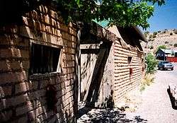 an old adobe wall and gate at a house in Madrid, New Mexico | |
  | |
| Location | The historic district encompasses the core of Madrid, New Mexico along both sides of the valley, from north of the baseball field to the intersection of Arroyo Road and NM 14 at the southern edge of the town |
|---|---|
| Coordinates | 35°24′21″N 106°9′16″W |
| Area | 200 acres (80 ha) |
| Built | 1892 |
| Architect | multiple |
| Architectural style | wooden miners' houses, some adobe and stone buildings |
| NRHP reference No. | 77000928[1] |
| NMSRCP No. | 356 |
| Significant dates | |
| Added to NRHP | November 9, 1977 |
| Designated NMSRCP | December 6, 1974 |
The district's nomination to the National Register of Historic Places was accompanied by photographs showing several contributing structures: the Roman Catholic church on Back Road; a former boarding house; a coal breaker; miners' houses on Opera House Road and Back Road; and company bungalows, other houses and the company headquarters on Main (Front) Street (now NM 14).[2]
References
Sources
- "National Register of Historic Places Inventory — Nomination Form: Madrid Historic District". National Park Service. November 9, 1977.
- "Photographs Accompanying NRHP Nomination: Madrid Historic District". National Park Service. November 9, 1977.
- Emmer, Regina N. (2012), "Madrid Historic District", in Esperdy, Gabrielle; Kingsley, Karen (eds.), SAH Archipedia, Charlottesville: University of Virginia Press, retrieved 2018-09-05
| Topics | |
|---|---|
| Lists by state |
|
| Lists by insular areas | |
| Lists by associated state | |
| Other areas | |
| Related | |
| |
This article is issued from Wikipedia. The text is licensed under Creative Commons - Attribution - Sharealike. Additional terms may apply for the media files.