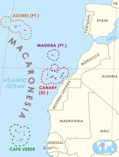
Macaronesia
Macaronesia (Portuguese: Macaronésia) is a collection of four archipelagos in the North Atlantic Ocean off the coast of the continents of Europe and Africa.[1] Each archipelago is made up of a number of Atlantic oceanic islands formed by seamounts on the ocean floor with peaks above the ocean's surface. The Macaronesian islands belong to three countries: Portugal, Spain, and Cape Verde.[2][3][4] Politically, the islands belonging to Portugal and Spain are part of the European Union. Geologically, Macaronesia is part of the African Plate, including the Azores, which mark its edge at the meeting point with the Eurasian and North American Plates.[5][6]
The European Union considers that the three European archipelagos (i.e. not including Cape Verde) conform a unique biogeographic region called the Macaronesian Region.[7]
Etymology
The name is derived from the Greek words for "islands of the fortunate" (μακάρων νῆσοι, makárōn nêsoi), a term used by Ancient Greek geographers for islands to the west of the Strait of Gibraltar. Macaronesia is occasionally misspelled "Macronesia" in false analogy with Micronesia, an unrelated Pacific archipelago containing, among other nations, a country of the same name.
Archipelagos
Macaronesia consists of four main archipelagos. From north to south, these are:[6]
- the Azores, an Autonomous Region of Portugal
- Madeira (also including the Savage Islands), an Autonomous Region of Portugal
- the Canary Islands, an Autonomous Community of Spain
- Cape Verde, an independent West African country
Geography and geology
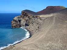
The islands of Macaronesia are volcanic in origin, and are thought to be the product of several geologic hotspots.
The climate of the Macaronesian islands ranges from maritime temperate, Mediterranean and subtropical in the Azores and Madeira, Mediterranean and subtropical in some Canary islands to arid in certain geologically older islands of the Canaries (Lanzarote, Fuerteventura), some islands of the Madeira Archipelago (Selvagens and Porto Santo) and Cape Verde (Sal, Boa Vista and Maio), and even tropical in the younger islands of both southern archipelagos (Santo Antão, Santiago and Fogo in Cape Verde). In some cases there are variations due to the rain shadow effect. The laurisilva forests of Macaronesia are a type of mountain cloud forest with relict species of a vegetation type which originally covered much of the Mediterranean Basin when the climate of that region was more humid. The species have evolved to adapt to the islands’ conditions and many are endemic.
The islands have a unique biogeography, and are home to several distinct plant and animal communities. The jumping spider genus Macaroeris is named after Macaronesia. None of the Macaronesian islands were part of a continent, so the native plants and animals reached the islands via long-distance dispersal. Laurel-leaved forests, called laurisilva, once covered most of the Azores, Madeira, and parts of the Canaries between 400 and 1200 m altitude (the eastern Canaries and Cape Verde being too dry). These forests resemble the ancient forests that covered the Mediterranean basin and northwestern Africa before the cooling and drying of the ice ages. Trees of the genera Apollonias, Clethra, Dracaena, Ocotea, Persea, and Picconia, which are found in the Macaronesian laurel forests, are also known from fossil evidence to have lived around the Mediterranean before the ice ages.
Conservation issues
.jpg)
Felling of the forests for timber and firewood, clearing vegetation for grazing and agriculture, and the introduction of foreign plants and animals by humans have displaced much of the original native vegetation. The laurisilva habitat has been reduced to small disconnected pockets. As a result, many of the endemic biota of the islands are now seriously endangered or extinct. Alien predators – in particular domestic and feral cats – are currently one of the most serious threats to the endemic fauna. Despite the fact that cats prey mostly on introduced mammals, such as rodents and rabbits, this feeding sustains a bigger feline population (thought to be a hyperpredation process), and has a further impact on the endemic reptiles and birds.[8]
In the European part of Macaronesia (Azores, Madeira and Canary Islands), conservation efforts include large areas protected by the Natura 2000 regulations of the European Union, since 2001. All in all, 5000 km² of land and sea are protected area in these three archipelagos.[9]
References
- "Where Is Macaronesia?". WorldAtlas. Retrieved 2019-07-08.
- "Countries .::. UCLA Africa Studies Center". www.international.ucla.edu. Retrieved 18 June 2019.
- "Canary Islands - Spain". greenwichmeantime.com. Retrieved 18 June 2019.
- "Makavol 2010 Teneguia Workshop" (PDF). Avcan.org. Archived from the original (PDF) on 2012-04-25. Retrieved 2013-09-02.
- "Africa-Eurasia plate boundary - I. Jimenez-Munt". diapiro.ictja.csic.es. Retrieved 2018-05-15.
- Brummitt, R.K. (2001). World Geographical Scheme for Recording Plant Distributions: Edition 2 (PDF). International Working Group on Taxonomic Databases For Plant Sciences (TDWG). p. 37. Archived from the original on 2016-01-25. Retrieved 2016-04-06.CS1 maint: BOT: original-url status unknown (link)
- "The Macaronesian Region". ec.europa.eu. Retrieved 2019-07-08.
- Jorge (28 March 2013). "Stray pets: Cat diet in Macaronesia (Atlantic Ocean)". Retrieved 18 June 2019.
- "The Macaronesian Region". European Commission. Retrieved 17 May 2017.
External links
| Wikimedia Commons has media related to Macaronesia. |