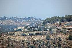
Ma'ale Shomron
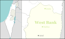
Ma'ale Shomron (Hebrew: מַעֲלֵה שׁוֹמְרוֹן), is an Israeli settlement in the northern West Bank. Located about 300 metres above sea level in the Samarian hills, it is organised as a community settlement and falls under the jurisdiction of Shomron Regional Council. In 2018 it had a population of 1,012.
Ma'ale Shomron מַעֲלֵה שׁוֹמְרוֹן | |
|---|---|
 | |
 Ma'ale Shomron | |
| Coordinates: 32°9′52.91″N 35°4′16.10″E | |
| Country | Israel |
| District | Judea and Samaria Area |
| Council | Shomron |
| Region | West Bank |
| Affiliation | Mishkei Herut Beitar |
| Founded | 1980 |
| Population (2018)[1] | 1,012 |
The international community considers Israeli settlements in the West Bank illegal under international law, but the Israeli government disputes this.[2]
History
The settlement was established in February 1980 by a mixed group of Orthodox and non-religious Israelis from the Beitar and Herut movements.[3] It is closely bordered by Karnei Shomron.
According to ARIJ, Israel confiscated land from several Palestinian villages in order to construct Ma'ale Shomron, including 268 dunums of land from Azzun,[4] 69 dunams from Deir Istiya,[5] and 367 dunums of land from Kafr Thulth / Arab Al Khouleh (including land for Karnei Shomron and Emmanuel).[6]
Notable residents
- Dani Dayan, Consul General of Israel in New York City and former head of Yesha Council
References
- "Population in the Localities 2018" (XLS). Israel Central Bureau of Statistics. 25 August 2019. Retrieved 26 August 2019.
- "The Geneva Convention". BBC News. 10 December 2009. Retrieved 27 September 2011.
- "Ma'ale Shomron". Shomron Regional Council (in Hebrew). Retrieved 30 July 2014.
- ‘Azzun Town Profile (including ‘Isla & ‘Izbat at Tabib Localities), ARIJ, 2013, p. 19
- Deir Istiya Town Profile, ARIJ, p. 18
- Kafr Thulth Town Profile (including ‘Arab al Khawla Locality), ARIJ, p. 17