Loyew District
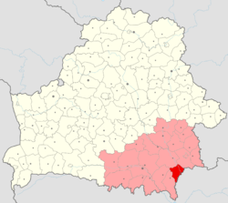
Loyew District or Lójeŭski Rajon (Belarusian: Лоеўскі раён, romanized: Lojeŭski rajon; Russian: Лоевский район, romanized: Loyevsky rayon) is a district (raion) of Belarus located in the Gomel Region. Its administrative center is Loyew.
Loyew District | |
|---|---|
 Flag  Coat of arms | |
 | |
| Country | |
| Voblast | |
| Seat | Loyew |
| Government | |
| • Chairman | Baikova Veronika Anatolyevna[1] |
| Area | |
| • District | 1,045.53 km2 (403.68 sq mi) |
| Population (2017)[2] | |
| • District | 12,024 |
| • Density | 12/km2 (30/sq mi) |
| • Urban | 6,739 |
| • Rural | 5,285 |
| Ethnicity | |
| • Belorusian | 92.92% |
| • Russian | 4.39% |
| • Ukrainian | 1.84% |
| • Other | 0.85% |
| Spoken Languages | |
| • Belorusian | 64.4% |
| • Russian | 32.5% |
| • Other | 3.1% |
| Time zone | UTC+2 (EET) |
| • Summer (DST) | UTC+3 (EEST) |
| Towns | 1 |
| Rural Councils | 7 |
| Settlements | 71 |
| Website | Official website |
History
The district was founded on 8 December 1926. It has been a part of the Gomel Region since 1938, after administrative reforms introduced regions in Byelorussian Soviet Socialist Republic (BSSR). The district was dissolved for several years in the 1960s, being abolished in December 1962 and reinstated in July 1966. It has been a district of Belarus since its independence from the USSR in 1991.
Geography
The area of the district is 1,046 km2 (404 sq mi). Forest makes up 37.7% of the district's land use, with 43.4% used for agricultural purposes as of 2010.[4] It is bordered in the west and north by Brahin, Khoiniki, Rechytsa, and Gomel districts of the same region, and in the east - along the Dnieper and partly along its tributary of the Sozh - with the Chernigov oblast of Ukraine. The largest body of water is the Dnieper-Brahin Reservoir. It contains the Dnieper-Sozh nature preserve.
Demographics
The population of the district was 12,024 as of 2017, with 6,739 living in Loyew and 5,285 living in rural settlements. The population density of the district is 12 km2 (4.6 sq mi). The ethnic composition in the 2009 census was 92.9% Belorusian, 4.4% Russian, and 1.8% Ukrainian. The mother tongue of 87% of the population was Belorusian and for 11.6% Russian. Belorusian is spoken at home by 64.4% of the population and Russian by 32.5% of the population.[2] The district's population has been in decline since the 1960s.
| Historical population | ||
|---|---|---|
| Year | Pop. | ±% |
| 1959 | 27,377 | — |
| 1970 | 24,615 | −10.1% |
| 1979 | 22,503 | −8.6% |
| 1989 | 20,402 | −9.3% |
| 1999 | 18,013 | −11.7% |
| 2009[3] | 14,346 | −20.4% |
| 2017[2] | 12,024 | −16.2% |
Administrative Division
The district encompasses one urban settlement and seven rural councils, which contain a total of 71 settlements.[5][6]
| English Name | Belarusian Name | Russian Name | Type | Villages | Population 2009[3] |
|---|---|---|---|---|---|
| Lójeŭ | Ло́еў | Лоев | urban settlement | 7,022 | |
| Byváĺkaŭski | Быва́лькаўскі | Бывальковский | rural council | 12 | 949 |
| Kárpaŭski | Ка́рпаўскі | Карповский | rural council | 6 | 589 |
| Kaŭpiénski | Каўпе́нскі | Колпенский | rural council | 6 | 1,375 |
| Malínaŭski | Малі́наўскі | Малиновский | rural council | 11 | 936 |
| Ručajoŭski | Ручаёўскі | Ручаёвский | rural council | 9 | 669 |
| Strádubski | Стра́дубскі | Страдубский | rural council | 18 | 2,032 |
| Ubórkaŭski | Убо́ркаўскі | Уборковский | rural council | 9 | 774 |
References
- "District Executive Committee". www.loev.gomel-region.by (in Russian). Retrieved 2018-01-18.
- "Population as of 1 January 2017 and the average annual population in 2016 in the Republic of Belarus by regions, districts, cities, and townships". www.belstat.gov.by (in Russian). Archived from the original on 16 July 2017. Retrieved 2018-01-16.
- "Final census data of the population of the Republic of Belarus in 2009". census.belstat.gov.by. Retrieved 2018-01-17.
- State Property Committee of the Republic of Belarus (1 Jan 2011). "State Land Cadastre of the Republic of Belarus". www.gki.gov.by (in Russian).
- "Geographic location". www.lelchitsy.gomel-region.by (in Russian). Retrieved 2018-01-17.
- "STATEKARTGEOCENTER". maps.by. Retrieved 2018-01-17.
| Districts (raions) |
|  |
|---|---|---|
| Cities | ||