Louisiana Highway 2 Alternate
Louisiana Highway 2 Alternate (LA 2 Alt.) is a state highway located in northern Louisiana. It runs 43.06 miles (69.30 km) in an east–west direction from Shongaloo to Bernice, connecting to its parent route at either end.
| |
|---|---|
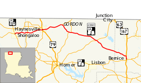 Route of LA 2 Alt. highlighted in red | |
| Route information | |
| Alternate route of LA 2 | |
| Maintained by Louisiana DOTD | |
| Length | 43.059 mi[1] (69.297 km) |
| Existed | 1955 renumbering–present |
| Major junctions | |
| West end | |
| |
| East end | |
| Location | |
| Parishes | Webster, Claiborne, Union |
| Highway system | |
| |
.svg.png)
LA 2 Alt. parallels the route of LA 2 to the north, traveling through the town of Haynesville, where it intersects U.S. Highway 79 (US 79). It is the only "Alternate" state route in Louisiana.
Route description
From the west, LA 2 Alt. begins at an intersection with LA 2 and LA 159 in Shongaloo. While LA 2 turns to the south co-signed with LA 159, LA 2 Alt. heads due east and crosses from Webster Parish into Claiborne Parish. Just across the parish line, LA 2 Alt. intersects LA 521. It then continues eastward for 4.0 miles (6.4 km) and enters the town of Haynesville. Here it intersects LA 534, crosses the Louisiana and North West Railroad (LNW) tracks, and intersects US 79. LA 2 Alt. turns south, approaching the center of town and overlapping US 79 for one block, before resuming an eastward course along Sherman Street. On the east edge of town, LA 2 Alt. intersects LA 807.[2][3][4][5]
After 5.7 miles (9.2 km), LA 2 Alt. intersects LA 161 at a point known as Gordon and curves to the southeast. 3.8 miles (6.1 km) later, it intersects LA 520, and the two highways engage in a brief concurrency until LA 520 turns north at Colquitt. LA 2 Alt. continues southeast for another 8.9 miles (14.3 km) to Summerfield. Here it zigzags briefly onto LA 9 before continuing southeast for 7.4 miles (11.9 km) to Weldon, where it crosses into Union Parish.[2][4][5]
LA 2 Alt. proceeds southeast into the town of Bernice, where it intersects and turns south onto the concurrent US 63/US 167. Approaching the center of town, eastbound (or southbound) traffic proceeds onto Plum Street while westbound (or northbound) traffic follows Cherry Street. LA 2 Alt. ends six blocks later when it reaches its parent route at 4th Street.[2][6][7]
LA 2 Alt. is an undivided two-lane highway for its entire length, except for the brief divided four-lane segment concurrent with US 63/US 167 at its eastern end.[2]
History
In the original Louisiana Highway system in use between 1921 and 1955, the entire route of LA 2 Alt. was part of State Route 70.[8][9][10]
LA 2 Alt. is an anomaly in the current system, being the only special state route designated in the 1955 renumbering and the only "Alternate" state route.[lower-alpha 1][11] Its route has seen only one major change, the relocation of its western terminus from Sykes Ferry to Shongaloo in the early 1970s.[12][13] The intervening route was assumed by LA 2, which was re-routed through Webster Parish at this time, shortening LA 2 Alt. by 5.0 miles (8.0 km). The only other change resulted from the recent widening of US 63/US 167 to four lanes in Bernice, concurrent with LA 2 Alt. at its eastern end, via the one-way pair of Plum and Cherry Streets.[6][14]
Major intersections
| Parish | Location | mi[1] | km | Destinations | Notes |
|---|---|---|---|---|---|
| Webster | Shongaloo | 0.000 | 0.000 | Western terminus | |
| Claiborne | | 4.547 | 7.318 | ||
| Haynesville | 9.709 | 15.625 | Northern terminus of LA 534 | ||
| 9.887 | 15.912 | Western end of US 79 concurrency | |||
| 9.943 | 16.002 | Eastern end of US 79 concurrency | |||
| 10.932 | 17.593 | Southern terminus of LA 807 | |||
| Gordon | 16.633– 16.704 | 26.768– 26.882 | Southern terminus of LA 161 | ||
| | 20.496 | 32.985 | Western end of LA 520 concurrency | ||
| Colquitt | 21.270 | 34.231 | Eastern end of LA 520 concurrency | ||
| Summerfield | 30.147 | 48.517 | Western end of LA 9 concurrency | ||
| 30.291 | 48.749 | Eastern end of LA 9 concurrency | |||
| Union | Bernice | 42.014 | 67.615 | Western end of US 63/US 167 concurrency | |
| 43.059 | 69.297 | Eastern terminus; eastern end of US 63/US 167 concurrency; one-way pair | |||
1.000 mi = 1.609 km; 1.000 km = 0.621 mi
| |||||
See also


Notes
- Several special routes were designated for U.S. routes in the 1955 renumbering, and special state routes have since been added.[11]
References
- Louisiana Department of Transportation and Development, Highway Inventory Unit (2016). "LRS Conversion Tool". Louisiana Department of Transportation and Development. Retrieved March 7, 2018.
- Google (March 7, 2018). "Overview Map of LA 2 Alternate" (Map). Google Maps. Google. Retrieved March 7, 2018.
- Louisiana Department of Transportation and Development, Office of Multimodal Planning (February 2012). Webster Parish (PDF) (Map). Scale not given. Baton Rouge: Louisiana Department of Transportation and Development. Retrieved March 28, 2013.
- Louisiana Department of Transportation and Development, Office of Multimodal Planning (February 2012). Claiborne Parish (PDF) (Map). Scale not given. Baton Rouge: Louisiana Department of Transportation and Development. Retrieved March 28, 2013.
- Louisiana Department of Transportation and Development, Office of Multimodal Planning (February 2012). District 04: Official Control Section Map, Construction and Maintenance (PDF) (Map). Scale not given. Baton Rouge: Louisiana Department of Transportation and Development. Retrieved March 28, 2013.
- Louisiana Department of Transportation and Development, Office of Multimodal Planning (February 2012). Union Parish (West Section) (PDF) (Map). Scale not given. Baton Rouge: Louisiana Department of Transportation and Development. Retrieved March 28, 2013.
- Louisiana Department of Transportation and Development, Office of Multimodal Planning (February 2012). District 05: Official Control Section Map, Construction and Maintenance (PDF) (Map). Scale not given. Baton Rouge: Louisiana Department of Transportation and Development. Retrieved March 28, 2013.
- Louisiana Department of Highways, Traffic and Planning Section (1949). Webster Parish (Map) (January 1, 1955 ed.). Scale not given. Baton Rouge: Louisiana Department of Highways.
- Louisiana Department of Highways, Traffic and Planning Section (1949). Claiborne Parish (Map) (January 1, 1955 ed.). Scale not given. Baton Rouge: Louisiana Department of Highways.
- Louisiana Department of Highways, Traffic and Planning Section (1948). Union Parish (Map) (January 1, 1955 ed.). Scale not given. Baton Rouge: Louisiana Department of Highways.
- "Act No. 40, House Bill No. 311". State-Times. Baton Rouge. June 18, 1955. p. 3B–7B.
- Louisiana Department of Highways (1971). Louisiana 1971 (Map). Scale not given. Baton Rouge: Louisiana Department of Highways.
- Louisiana Department of Highways (1976). Louisiana 1976 (Map). Scale not given. Baton Rouge: Louisiana Department of Highways.
- Louisiana Department of Transportation and Development, Office of Planning and Programming (1996). Union Parish (Map) (2000 ed.). Scale not given. Baton Rouge: Louisiana Department of Transportation and Development.
External links
- Maps / GIS Data Homepage, Louisiana Department of Transportation and Development