Longnor, Shropshire
Longnor is a village and civil parish off the A49 road, south of Dorrington and north of Leebotwood in Shropshire, England, with a population of 289. The nearest railway station is Church Stretton 4.7 miles (7.6 km) away. The Cound Brook flows just west of the village and its medieval deer park. The village contains Longnor Hall and the Grade I listed medieval St Mary's Church. Regional Cycle Route 32/33 passes through, as do buses between Church Stretton and Shrewsbury and Radbrook Green. The village is also noted for a ghost, the White Lady of Longnor.
| Longnor | |
|---|---|
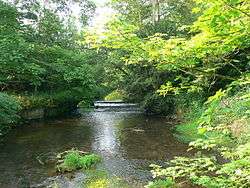
 The ford at the Old Forge, Longnor | |
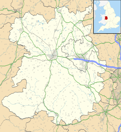 Longnor Location within Shropshire | |
| Population | 289 (2011)[1] |
| OS grid reference | SJ485005 |
| Civil parish |
|
| Unitary authority | |
| Ceremonial county | |
| Region | |
| Country | England |
| Sovereign state | United Kingdom |
| Post town | SHREWSBURY |
| Postcode district | SY5 |
| Dialling code | 01743 |
| Police | West Mercia |
| Fire | Shropshire |
| Ambulance | West Midlands |
| UK Parliament | |
Facilities
Education
Longnor CE Primary School is the village primary school, which has a pre-school attached.[2][3] In January 2011 it had 112 pupils aged between five and eleven. Its 2018 SAT results put it in the top 1 per cent of schools in England for the percentage of children reaching and exceeding expected standards in writing and mathematics. The pre-school section is called Little Owls.<[4] The nearest secondary school is in Church Stretton.[5]
Church
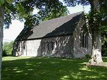
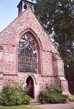
St. Mary's Church is a Grade 1 Listed Building in the medieval Early English style. It has been continually and carefully conserved down the centuries. Two new stained glass windows were installed in 2000, to mark the turn of the millennium.
Originally a chapel for Condover, it became a private chapel for the Corbett family of Longnor Hall, before taking on the function of a parish church.[6]
Longnor was the birthplace of Samuel Lee (1783–1853), a linguist, Cambridge academic and Anglican cleric, whose translations from the Bible and other religious works into Arabic and other languages helped to launch the missionary activities of the Evangelical movement in the first half of the 19th century.[7]
Food and drink
The nearest restaurant is 1.7 miles (2.7 km) away in Leebotwood, south-east of Longnor. It is called The Pound and serves British cuisine.[8] The nearest pub is the Fox Inn, which is 1.7 miles northwards in Little Ryton and also serves meals, including vegetarian.[9]
Local government
Leebotwood & Longnor PC
Longnor is part of a joint parish council with the village of Leebotwood. In 2008, the electorate in the parish was 343 members, who vote on matters such as improving the quality of life of the two communities and looking after the environment. It influences and works alongside the principal authority Shropshire Council, Police, Highways Agency, PCT.[10]
Longnor Hall
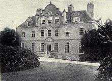
Longnor Hall features a park and formal gardens, the park originated in the 14th century. In the 17th century it was turned from being a park to having formal gardens laid out. It is now left with having the 18th-century park and modern gardens still surviving.[11] The current hall was built by Sir Richard Corbett in 1670 as successor for Roger Sprencheaux's fortified manor house from 1235.[12] The hall had some alterations done in 1838–1842 by the architect and builder Edward Haycock Sr.[13][14]
Corbet family
The Corbet family were the builders and original inhabitants of Longnor Hall. Sir Richard Corbett's hall, begun in 1670, was finished in 1693 for his son, Uvedale Corbett.[13] The name of Corbet arrived in Shropshire in the times of the Norman Conquest, when Hugh Corbet settled in the area. The branch of the Corbett family living in Longnor dates from the 1500s. The last in this line was Jane Corbett, who married Archdeacon Joseph Plymley. However, he took on the name Corbett and it has continued, although many Corbets or Corbetts had moved away from Shropshire by the 19th century.[15]
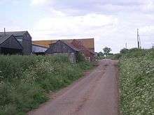
Farming
Longnor is home to numerous different farms, five of which are Micklewood Farm, Shrubbery Farm, Upper House Farm, The Farm, and Green Farm.[16] These are the main economic force in the area, most of the employment having been agricultural throughout history.[17] Green Farm specializes in the dairy industry. It installed a modern milking facility in 2010.[18]
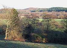
Natural features
Cound Brook
Cound Brook is a 25-mile-long (40 km) tributary of the River Severn running from the All Stretton area through Longnor and Condover and emptying into the Severn near Cound. Longnor lies in the middle section of Cound Brook. Having rainwater runoff from the Stretton Hills join it, the brook widens, passing to the east of Leebotwood and west of Longnor and the Medieval deer park there. Continuing east of Dorrington village, it changes direction to east at Stapleton. The flow can vary from slow and sluggish in a dry summer to a torrent in winter or spring.[19]
Climate and environment
The temperate climate in the area of Longnor is typical for this part of England. However, occasional extremes can occur. In April 2012, there were snow storms.[21][22]
History
In 1870–1872, John Marius Wilson's Imperial Gazetteer of England and Wales described Longnor like this:
Longnor, a village and a parish in Church-Stretton district, Salop. The village stands on the Cound Brook, near Watling-street, 1½ mile NNE of Leebotwood r. station, and 5 NNE of Church-Stretton; and is supposed to occupy the site of a Roman station. The parish comprises 1,200 acres; and its Post town is Leebotwood, under Shrewsbury. Real property, £3,656; of which £88 are in mines. Pop., 244. Houses, 48. The property is divided among a few. Longnor Hall is a chief residence. Coal is found, but is worked less now than formerly. The living is a vicarage annexed to the vicarage of Leebotwood, in the diocese of Lichfield. The church is ancient but good; and belonged formerly to Haughmond abbey. There are a national school, and charities £44. The Rev. Samuel Lee, late professor of Arabic at Cambridge, was a native.[23]
Shropshire ghost
The White Lady of Longnor is said to appear clothed in a long white wedding dress, on or near the road bridge near the village, where she is thought to have thrown herself into the water below, after being deserted at the altar.[24]
Transport
Road
| |
|---|---|
| Route information | |
| Length | 140 mi (230 km) |
| Road network | |
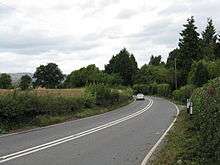
The A49, is the main road that passes by Longnor just to the West of the village. It heads from South to North traversing the Welsh Marches region from Hereford to Wigan. The road provides the main routes from Longnor into the surrounding towns and villages, especially into Shrewsbury and Church Stretton, with Church Stretton being where the nearest shops are to Longnor as it is the nearest town. The A49 is also the road which has the bus links for the people of Longnor, having the number 435 bus stopping just to the North of the village on the road.[25]
Cycling
Route 32/33 links the village with the National Cycle Network, which runs between Little Ryton and All Stretton as part of National Cycle Route 44.[26]
Trains
The nearest railway station to Longnor is 4.7 miles (7.6 km) away in Church Stretton on the Welsh Marches Line. The station is on the 435 bus route between Longnor and Shrewsbury. The nearest mainline station is in Shrewsbury, 7.7 miles (12.4 km) to the north.[27]
Buses
Longnor is served by bus routes numbered 435 and 540. Both start from Church Stretton, being the largest town nearby. The 435 takes in a number of different villages, including Longnor, on its way to Shrewsbury. The 540 runs to Radbrook Green, a suburb of Shrewsbury.[27]
References
- "Civil Parish population 2011". Retrieved 28 November 2015.
- Retrieved 29 April 2020.
- OFSTED
- School site. Retrieved 29 April 2020.
- http://www.achurchnearyou.com/longnor-st-mary/
- Nile Green: Terrains of Exchange. Religious Economies of Global Islam (London: C. Hurst & Co., 2014), pp. 59–64.
- Retrieved 29 April 2020.
- "Archived copy". Archived from the original on 2 October 2013. Retrieved 2012-05-02.CS1 maint: archived copy as title (link)
- http://www.melocki.org.uk/salop/Longnor.html
- "Archived copy". Archived from the original on 29 May 2012. Retrieved 1 May 2012.CS1 maint: archived copy as title (link)
- Archived 9 November 2013 at the Wayback Machine
- Archived 2 April 2015 at the Wayback Machine
- Rackham, Oliver (1976). Trees and Woodland in the British Landscape. Archaeology in the Field Series. London: J.M. Dent & Sons Ltd. p. 150. ISBN 0 460 04183 5.
- "Archived copy". Archived from the original on 26 September 2011. Retrieved 19 April 2012.CS1 maint: archived copy as title (link)
- Southall, H. "Longnor History". Vision of Britain.
- National Rail. "Longnor Buses". Archived from the original on 30 April 2011.
External links
| Wikimedia Commons has media related to Longnor, Shropshire. |
| Unitary authorities | |
|---|---|
| Major settlements | |
| Rivers | |
| Canals | |
| Topics | |