Lockwood Island
Lockwood Island (Danish: Lockwood Ø) is an island of the Lincoln Sea, Greenland.[1] Administratively it belongs to the Northeast Greenland National Park.
| Lockwood Ø | |
|---|---|
 Lockwood Island | |
| Geography | |
| Location | Weyprecht Fjord Lincoln Sea |
| Coordinates | 83°21′N 39°20′W |
| Length | 12 km (7.5 mi) |
| Width | 5 km (3.1 mi) |
| Highest elevation | 760 m (2,490 ft) |
| Administration | |
| Zone | Northeast Greenland National Park |
| Demographics | |
| Population | 0 |
Lockwood Island is the northernmost sizeable coastal island of Greenland. The waters around the island are frozen the year round.
History
This island was named after U.S. Arctic explorer James Booth Lockwood (1852-1884). Lockwood and Sgt. David Legge Brainard achieved a new "farthest north" record of 83°23'8" on the island at the time of Greely's Lady Franklin Bay Expedition.[2]
Geography
Lockwood Island is located at the mouth of Weyprecht Fjord, its western shore forming the eastern side of the area at the entrance of the fjord. On the eastern shore of the island 3 km (1.9 mi) broad Conger Sound separates it from Cape Kane in Roosevelt Land in the mainland whose northernmost point is Cape Washington to the east beyond Hunt Fjord.[1]
Cape Christiansen is the headland at the northern end and small Brainard Island lies 2.7 km (1.7 mi) west of Lockwood Island's western shore. The island rises to a height of 760 m (2,490 ft) and the waters around it are icebound most of the year.[3]
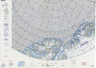 Map of part of Ellesmere Island and far Northern Greenland. |
References
- "Lockwood Ø". Mapcarta. Retrieved 29 May 2019.
- Geographical Items on North Greenland Encyclopedia Arctica 14: Greenland
- Prostar Sailing Directions 2005 Greenland and Iceland Enroute, p. 95
External links
- Ivar Haug, Gazetteer of Greenland, UBiT (Universitetsbiblioteket i Trondheim), ISBN 82-7113-114-1