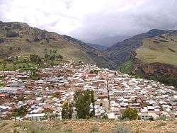
Llata District
Llata District is one of eleven districts of the Huamalíes Province in Peru.[1]
Llata | |
|---|---|
 Llata | |
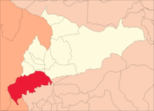 Location of Llata in the Huamalíes Province | |
| Country | |
| Region | Huánuco |
| Province | Huamalíes |
| Capital | Llata |
| Government | |
| • Mayor | Eduardo Grover Quino Herrera |
| Area | |
| • Total | 411.35 km2 (158.82 sq mi) |
| Elevation | 3,439 m (11,283 ft) |
| Population (2005 census) | |
| • Total | 14,660 |
| • Density | 36/km2 (92/sq mi) |
| Time zone | UTC-5 (PET) |
| UBIGEO | 100501 |
Geography
One of the highest peaks of the district is Millwa Pillu at approximately 4,600 m (15,100 ft). Other mountains are listed below:[2]
- Aqullan
- Artisa Ukru
- Hatun K’uchu
- Inti Punku
- Mama Hirka
- Marayniyuq
- Minas Puchka
- Minas Punta
- Pawqar
- Pilanku
- P'itiq Punta
- Tinyaq
- Usnu Rumi
- Waman Willka
- Warmi Wañusqa
- Yanama
Ethnic groups
The people in the district are mainly indigenous citizens of Quechua descent. Quechua is the language which the majority of the population (50.46%) learnt to speak in childhood, 49.12% of the residents started speaking using the Spanish language (2007 Peru Census).[3]
See also
References
- (in Spanish) Instituto Nacional de Estadística e Informática. Banco de Información Distrital Archived 2008-04-23 at the Wayback Machine. Retrieved April 11, 2008.
- escale.minedu.gob.pe/ UGEL map Huamalíes Province (Huánuco Region)
- inei.gob.pe Archived 2013-01-27 at the Wayback Machine INEI, Peru, Censos Nacionales 2007, Frequencias: Preguntas de Población: Idioma o lengua con el que aprendió hablar (in Spanish)
| |
|---|---|
| Ambo | |
| Dos de Mayo | |
| Huacaybamba | |
| Huamalíes | |
| Huánuco | |
| Lauricocha | |
| Leoncio Prado | |
| Marañón | |
| Pachitea | |
| Puerto Inca | |
| Yarowilca | |
This article is issued from Wikipedia. The text is licensed under Creative Commons - Attribution - Sharealike. Additional terms may apply for the media files.