Llantilio Pertholey
Llantilio Pertholey (Welsh: Llandeilo Bertholau) is a small village and community (parish) in Monmouthshire, south east Wales. It is located 1.5 miles (2.4 km) to the north-east of the market town of Abergavenny, which it is part of, just off the A465 road to Hereford. The parish covers a large area beneath the Skirrid, an outlier of the Black Mountains; much of the parish lies within the easternmost part of the Brecon Beacons National Park.
Llantilio Pertholey
| |
|---|---|
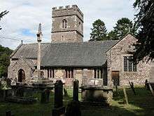 Church of St. Teilo, Llantilio Pertholey | |
 Llantilio Pertholey Location within Monmouthshire | |
| Population | 3,906 (2011)[1] |
| OS grid reference | SO312164 |
| Principal area | |
| Ceremonial county | |
| Country | Wales |
| Sovereign state | United Kingdom |
| Post town | ABERGAVENNY |
| Postcode district | NP7 |
| Dialling code | 01873 |
| Police | Gwent |
| Fire | South Wales |
| Ambulance | Welsh |
| UK Parliament | |
Governance
The village falls in the 'Mardy' electoral ward. This ward stretches to the east. The total population taken at the 2011 census was 1,469.[2]
History and amenities
The 13th century medieval Church of St Teilo is named after a 6th-century Bishop of Llandaff who was canonised for his good works. The church is a fine example of a rural Welsh church with three chantry chapels dating from about 1350.
The hamlet also had a primary school, which moved to the nearby Mardy district of Abergavenny in 1991. A popular pub, The Mitre, opposite the church closed some years ago.
References
- "Parish population 2011". Retrieved 4 April 2015.
- "Mardy ward 2011". Retrieved 4 April 2015.
External links
| Wikimedia Commons has media related to Llantilio Pertholey. |
- St. Teilo's Church website
- Llantilio Pertholey Primary School
- Old photo of the church
- Recent photo of the church
- Kelly's Directory of Monmouthshire 1901
- Map sources for Llantilio Pertholey