Little Mikwam River
The Little Mikwam River is a tributary of the Mikwam River (via Mikwam Lake), flowing into the Cochrane District, Northeastern Ontario, in Canada.
| Little Mikwam | |
|---|---|
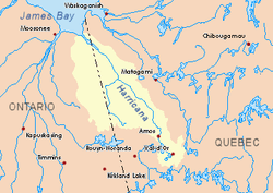 Harricana River basin in yellow | |
| Location | |
| Country | Canada |
| Province | Ontario |
| District | Cochrane |
| Physical characteristics | |
| Source | |
| ⁃ location | Cochrane District, Ontario |
| ⁃ coordinates | 49°29′41″N 80°06′26″W |
| ⁃ elevation | 309 m (1,014 ft) |
| Mouth | Mikwam River |
⁃ location | Cochrane District, Ontario |
⁃ coordinates | 49°31′01″N 79°09′25″W |
⁃ elevation | 293 m (961 ft) |
| Length | 11.3 km (7.0 mi)[1] |
Forestry is the main economic activity of the sector; recreational tourism activities, second. The west side of this slope is served by the Ontario Highway 652.
The surface of the river is usually frozen from early November to mid-May, but safe circulation on the ice generally occurs from mid-November to the end of April.
Geography
The neighboring hydrographic slopes of the" Little Mikwam River" are:
- North side: Mikwam River, Burntbush River;
- East side: Porphyry Creek, Mikwam River, Burntbush River;
- South side: Porphyry Creek, East Mikwam River;
- West side: Mikwam River, Tweed River, Floodwood River.
The "Little Mikwam River" originates at the mouth of a small forest lake (altitude: 309 metres (1,014 ft)). From its source, the "Little Mikwam river" flows on 11.3 kilometres (7.0 mi) according to the following segments:
- 5.6 kilometres (3.5 mi) in Blakelock Township to the south-east, then forks north-westerly to the south shore of "Little Lake Mikwam";
- 4.0 kilometres (2.5 mi) westward through the "Little Lake Mikwam" (length: 4.4 kilometres (2.7 mi); altitude: 298 metres (978 ft));
- 1.7 kilometres (1.1 mi) to South-West, up to the mouth.[2]
The confluence of the "Little Mikwam River" is located in Blakelock Township, at 46.2 kilometres (28.7 mi) west of the Ontario - Quebec border; 17.6 kilometres (10.9 mi) southwest of the mouth of the Mikwam River; 44.7 kilometres (27.8 mi) west of the mouth of the Burntbush River; 71 kilometres (44 mi) south of a bay south of Kesagami Lake and 9.1 kilometres (5.7 mi) to the southeast of the Ontario Highway 652.
Toponymy
The following names are of the same origin and are in the same area of the Cochrane District: Mikwam River, Little Wikwam River, East Mikwam River, Mikwam Lake, Mikwam Lake, Mikwam Lake superior.
See also
- Mikwam River, a river
- Burntbush River, a watercourse
- Turgeon River, a stream
- Harricana River, a watercourse
- James Bay
- Cochrane District (Ontario)
- Northeastern Ontario
- List of rivers of Ontario
References
- Atlas of Canada
- Distances measured from the Atlas of Canada (published on the Internet) of the Department of Natural Resources of Canada.