List of public art in Wolverhampton
This is a list of public art in Wolverhampton, in the West Midlands, England. This list applies only to works of public art accessible in an outdoor public space. For example, this does not include artwork visible inside a museum.
Wolverhampton
City Centre
Queen Square
| Image | Title / subject | Location and coordinates |
Date | Artist / designer | Type | Material | Dimensions | Designation | Owner / administrator | Wikidata | Notes |
|---|---|---|---|---|---|---|---|---|---|---|---|
.jpg) More images |
Equestrian statue of Prince Albert | Queen Square, Wolverhampton 52.585908°N 2.128333°W |
1866 | Thomas Thornycroft | Equestrian statue | Bronze | Grade II listed[1] | Wolverhampton City Council | Q26497548 | ||
%2C_Wolverhampton_-_geograph.org.uk_-_1181186.jpg) More images |
Allegorical Figures of Industry and Agriculture | NatWest Bank – Corner of Exchange Street – Queen Square, Wolverhampton 52.586035°N 2.128956°W |
1905 | Sculpture | Stone | 1m high x 2m wide approx. | NatWest Bank | [2] | |||
%2C_Wolverhampton_-_geograph.org.uk_-_1173333.jpg) More images |
Scenes of Mining, Agriculture and Industry | Lloyds Bank – Queen Square and Dudley Street, Wolverhampton 52.585767°N 2.127479°W |
1878 | J A Chatwin | Relief panels | Stone | 3 panels: 50cm high x 150cm wide approx | Grade II listed[3] | Lloyds Bank | [4] |
St Peter's Gardens
| Image | Title / subject | Location and coordinates |
Date | Artist / designer | Type | Material | Dimensions | Designation | Owner / administrator | Wikidata | Notes |
|---|---|---|---|---|---|---|---|---|---|---|---|
.jpg) More images |
Lady Wulfrun | St Peter's Collegiate Church, Wolverhampton 52.586807°N 2.128559°W |
1974 | Sir Charles Wheeler | Statue | Bronze | Wolverhampton City Council | Lady Wulfrun is regarded as the founder of Wolverhampton[5] | |||
.jpg) More images |
Douglas Morris Harris | St Peter's Gardens, Wolverhampton 52.586670°N 2.127679°W |
1919 | Robert Jackson Emerson | War memorial Bust | Bronze | Grade II listed[6] | Wolverhampton City Council | Q26638004 | A bust of Able Seaman Harris who continued to record messages on the ship Floandi before he was hit and killed in 1917[7] | |
.jpg) More images |
Saxon Cross Shaft | St Peter's Gardens, Wolverhampton 52.586716°N 2.128215°W |
c. 850AD | Cross | Stone | 4.2m high approx. | Wolverhampton City Council | Q16903638 | The cross shaft is the oldest man-made object in Wolverhampton[8] | ||
_-_geograph.org.uk_-_1077556.jpg) More images |
Allegories of the Arts, Sciences and Industry | Wolverhampton Art Gallery – Lichfield Street and St Peter's Walk, Wolverhampton 52.586833°N 2.127260°W |
1883 | J A Chatwin | Relief | Portland stone | Reliefs x 2: 2m x 8m. Reliefs x 2: 2m x 16m | Grade II* listed[9] | Wolverhampton City Council | [10] | |
.jpg) More images |
Allegorical Figures and Cartouche | University of Wolverhampton – Wulfruna Street, Wolverhampton 52.587440°N 2.127700°W |
1933 | Col G. C. Lowbridge | Sculpture | Sandstone | 1.8m high x 1.2m wide | University of Wolverhampton | [11] |
Wolverhampton Station
| Image | Title / subject | Location and coordinates |
Date | Artist / designer | Type | Material | Dimensions | Designation | Owner / administrator | Notes |
|---|---|---|---|---|---|---|---|---|---|---|
.jpg) More images |
Iron Horse | Between platform 2 and 3 at Wolverhampton station, Wolverhampton 52.587329°N 2.118978°W |
1987 | Kevin Atherton | Sculpture | Painted steel | 1.8m high x 2.4m long | Network Rail | One of a series of 12 between Wolverhampton station and Birmingham New Street station[12] | |
.jpg) More images |
Signal Man | Premier Inn Wolverhampton City Centre Hotel, Wolverhampton 52.588437°N 2.119900°W |
2007 | Giles Penny | Sculpture | Premier Inn | [13] | |||
 More images |
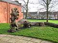
Railcar | Broad Gauge Way apartments – Wolverhampton 52.588556°N 2.118603°W |
2007 | Mick Thacker | Sculpture | 500cm x 500 cm | Celebrates the history of Wolverhampton Low Level station.[14] Also known as Locomotion 2.[15] |
Ring Road
| Image | Title / subject | Location and coordinates |
Date | Artist / designer | Type | Material | Dimensions | Designation | Owner / administrator | Notes |
|---|---|---|---|---|---|---|---|---|---|---|
.jpg) |
Echelon with Concrete Pillars | University of Wolverhampton – School of Art and Design – Ring Road St Peter's, Wolverhampton 52.589317°N 2.128333°W |
1972 | Hubert Dalwood | Sculpture | Concrete | University of Wolverhampton | [16] | ||
.jpg) |
Sculpture near the University of Wolverhampton School of Art | University of Wolverhampton – School of Art and Design – Ring Road St Peter's, Wolverhampton 52.589440°N 2.128677°W |
1970 | Sculpture | Concrete | University of Wolverhampton | ||||
.jpg) More images |
Gears sculpture | Small park between Ring Road St Patricks and Broad Street Basin, Wolverhampton 52.588867°N 2.123001°W |
2012 | Sculpture | Steel | Wolverhampton City Council | One is near Little's Lane and one is near Wednesfield Road (first appears on Google Street Map view in October 2012) | |||
.jpg) More images |
Sarcophagus sculpture | Small park between Ring Road St Patricks and Broad Street Basin, Wolverhampton 52.589134°N 2.123140°W |
Sculpture | Stone | Wolverhampton City Council | Kind of looks like a Sarcophagus | ||||
 |
Ionic Order | Wednesfield Road and Ring Road St Patricks, Wolverhampton 52.588343°N 2.123059°W |
1991 | Hugh Tessier | Sculpture | Brick pedestal & Steel column | 500cm high approx | Wolverhampton City Council | Used to be on Pipers Row near the old Wolverhampton bus station before it was moved to this location[17] |
Wolverhampton Wanderers FC
| Image | Title / subject | Location and coordinates |
Date | Artist / designer | Type | Material | Dimensions | Designation | Owner / administrator | Notes |
|---|---|---|---|---|---|---|---|---|---|---|
 More images |
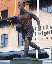
Billy Wright | The Molineux – Wolverhampton 52.590039°N 2.131878°W |
1996 | James Butler | Statue | Bronze | Wolverhampton Wanderers F.C. | [18] As of mid January 2017, the plaques below the statue have been damaged due to a car crash [19] | ||
 More images |
Stan Cullis | The Molineux – Wolverhampton 52.59111°N 2.1308°W |
2003 | James Butler | Statue | Bronze | Wolverhampton Wanderers F.C. | Former player and manager of Wolverhampton Wanderers from 1934 to 1964 [20] | ||
.jpg) More images |
Sir Jack Hayward | The Molineux – Wolverhampton 52.589441°N 2.131415°W |
2018 | James Butler | Statue | Bronze | Wolverhampton Wanderers F.C. | Was the owner of Wolves for 17 years until 2007.[21] |
Other city centre areas
| Image | Title / subject | Location and coordinates |
Date | Artist / designer | Type | Material | Dimensions | Designation | Owner / administrator | Notes |
|---|---|---|---|---|---|---|---|---|---|---|
.jpg) More images |
The Wheatsheaf | The Wheatsheaf – Tower Street, Wolverhampton 52.584689°N 2.125276°W |
Sculpture | |||||||
.jpg) More images |
City Gateway | Either side of Stafford Street, Wolverhampton 52.589004°N 2.126327°W |
2008 | Julia Rowley | Sculpture | Stainless steel, glass & acrylic | 5 metres | Gateway East near Thornley Street. Gateway West near a University of Wolverhampton building[22] | ||
 |
Sunbeam Car Panels | St. John's Retail Park, Wolverhampton 52.57963°N 2.12734°W (approx) |
1995 | Steve Field, John McKenna | Relief sculpture | Bronze | 3m by 2m | St John's Retail Park | [23] | |
 More images |
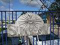
Historical Car and Motorcycle Company Logos | Railings of St John's Retail Park, Wolverhampton 52.579655°N 2.126114°W |
1995 | Steve Field, John McKenna | Sculpture | Steel, with applied surface, silver/grey | Fence panels: Slight variations but one is 36cm high x 62 cm wide, another is 50cm diameter. Large panel:100cm diameter approx | St John's Retail Park | Logos for Guy, The Sunbeam, Clyno etc[24] | |
 |
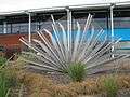
Out of the Darkness Cometh Light | Sainsbury's – St Mark's Street, Wolverhampton 52.583931°N 2.135516°W |
2014 | Planet Art (Julie Edwards & Ron Thompson) | Sculpture | Stainless steel | 8m | Sainsbury's | Stainless steel vase sculpture for the new Sainsbury's Raglan Street store[25] |
West Park
| Image | Title / subject | Location and coordinates |
Date | Artist / designer | Type | Material | Dimensions | Designation | Owner / administrator | Wikidata | Notes |
|---|---|---|---|---|---|---|---|---|---|---|---|
.jpg) More images |
Charles Pelham Villiers | West Park, Wolverhampton 52.58984°N 2.1408°W |
1878 | W.Theed the younger | Statue | Ashlar | Grade II listed[26] | Wolverhampton City Council | Q26497586 | MP for Wolverhampton for 63 years. The statue was moved from its original position in Snow Hill in 1931. | |
 More images |
Victorian Sewer | West Park, Wolverhampton 52.587238°N 2.138652°W |
1970s | Sculpture | Brick | Wolverhampton City Council | Built for a Wolverhampton Fiesta in the 1970s |
Blakenhall
| Image | Title / subject | Location and coordinates |
Date | Artist / designer | Type | Material | Dimensions | Designation | Owner / administrator | Notes |
|---|---|---|---|---|---|---|---|---|---|---|
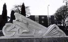 |
The Lone Rider | Penn Road, Blakenhall, Wolverhampton 52.575861°N 2.135798°W |
1996 | Steve Field | Sculpture | Hoptonwood limestone | Marks the site of the former AJS motorcycle factory. Carved by Robert Bowers, assisted by Michael Scheuermann.[23][27] |
Heath Town
| Image | Title / subject | Location and coordinates |
Date | Artist / designer | Type | Material | Dimensions | Designation | Owner / administrator | Notes |
|---|---|---|---|---|---|---|---|---|---|---|
 |
Reflective Metal Bridge | Wyrley and Essington Canal – Heath Town, Wolverhampton 52.593075°N 2.101318°W |
Sculpture | Steel | [28] |
New Cross Hospital
| Image | Title / subject | Location and coordinates |
Date | Artist / designer | Type | Material | Dimensions | Designation | Owner / administrator | Notes |
|---|---|---|---|---|---|---|---|---|---|---|
 |
Circle of Life | New Cross Hospital – Heath Town, Wolverhampton 52.596936°N 2.096624°W |
1998 | Katie Chambers | Sculpture | Concrete & pebbles | Plinth: 57cm high x 3.5m diameter. Outer ring: 3m diameter. Inner cylinder: 60cm diameter x 32cm deep. Bed: 6.3m diameter. | Wolverhampton City Council | [29] | |
 |
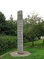
Lettered Column | New Cross Hospital – Wolverhampton Road, Heath Town, Wolverhampton 52.596965°N 2.094213°W |
2002 | Meic Watts | Sculpture | Granite blocks, steel | 5.2m high, with circumference of 2.8m at base | Wolverhampton City Council | [30] | |
 |
New Cross Column | New Cross Hospital – Wolverhampton Road, Heath Town, Wolverhampton 52.596714°N 2.094863°W |
2002 | Sculpture | Granite blocks | Wolverhampton City Council |
Bilston
Town Centre
| Image | Title / subject | Location and coordinates |
Date | Artist / designer | Type | Material | Dimensions | Designation | Owner / administrator | Notes |
|---|---|---|---|---|---|---|---|---|---|---|
 More images |
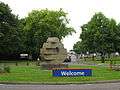
High Street entrance marker | Junction of Dudley Street and High Street, Bilston 52.564334°N 2.079195°W |
1999 | Kate Maddison of Chrysalis Arts | Sculpture | Steel, natural, gold and blue | 6.5m high | Wolverhampton City Council | The top of the spiral has two flying doves on it. [31][32] | |
 More images |
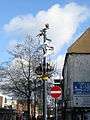
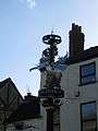
Church Street entrance marker | Junction of Lichfield Street and Church Street, Bilston 52.566198°N 2.074051°W |
2004 | Kate Maddison of Chrysalis Arts | Sculpture | Steel | 7.5-metre column | Wolverhampton City Council | Has a gilded rising sun and a stainless steel mantle[32] | |
.jpg) More images |
Women's Work | Outside the Horse and Jockey, Church Street, Bilston 52.565688°N 2.076406°W |
May 1998 | Rose Garrard | Sculpture | Bronze | Wolverhampton City Council | A female figure beside a pit-head gantry, commemorates the impoverished women working in the 19th century coal and iron industries of the Black Country. [33] Based on a 19th Century photograph of a pit bank wench or coal picker from Bilston [34] | ||
 |
Amber the Fire Breather | back garden of Bilston Craft Gallery and Museum – Mount Pleasant, Bilston 52.568003°N 2.071568°W |
1994 | Graham Jones | Sculpture | Oak and sweet chestnut | 12m long | Wolverhampton City Council | [35] | |
 More images |
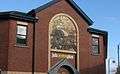
Industrial Images | Job Centre Plus – Junction of Smith Street and High Street, Bilston 52.564262°N 2.079809°W |
1995 | John McKenna | Relief | Brick, red and buff, partially painted | 3m x 2.75m | Job Centre Plus | [36] Brick relief panel was depicting former Bilston Industry[37] | |
 More images |
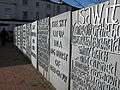
Witness | Church Street bridge, Bilston 52.566021°N 2.075504°W |
1997 | Bettina Furnee | Sculpture | Cast iron | Wolverhampton City Council | Text composed using tape recordings from an oral history project looking back at the local steel industry which came to an end in the 1980s. On 14 panels. [38] [39] |
Black Country Route
| Image | Title / subject | Location and coordinates |
Date | Artist / designer | Type | Material | Dimensions | Designation | Owner / administrator | Notes |
|---|---|---|---|---|---|---|---|---|---|---|
.jpg) More images |
Hovering kestrel | Citadel Logistics Building on the Black Country Route, Bilston 52.568519°N 2.055003°W |
2009 | John McKenna | Sculpture | Stainless steel | Wolverhampton City Council | [40] | ||
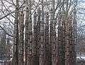 More images |
Steel Columns | next to footpath adjacent to Oxford Street Roundabout near Black Country Route, Bilston 52.565072°N 2.071207°W |
1996 | Robert Koenig | Sculpture | Sweet Chestnut trunks, painted black, red, and yellow | Front row: 450cm high x 38cm diameter, middle row: 505cm high x 40cm diameter, back row: 560cm high x 45cm diameter | Wolverhampton City Council | [41] | |
 More images |
Steel Monoliths | Roundabout between Millfields Road, High Street, Wolverhampton Street and Coseley Road near Black Country Route, Bilston 52.563571°N 2.083344°W |
1996 | Miles Davis | Sculpture | Core-ten steel | Approximately 10m high | Wolverhampton City Council | [42] Sculpture consisting of 3 steel monoliths about 10 meters high to reflect Bilston’s engineering past. [43] | |
 More images |
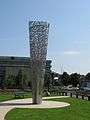
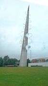
Tower of Light | Adjacent to Bilston Football Club – Vulcan Roundabout – Black Country Route, Bilston 52.565571°N 2.065191°W |
1998 | Ellis O'Connell | Sculpture | Stainless steel | 16.5m high x 2m diameter at base | Wolverhampton City Council | [44] A large outdoor sculpture in stainless steel, glass and fibre optics [45] | |
 More images |
Beth's Arch | Roundabout adjacent to Bilston firestation – Black Country Route, Bilston 52.562183°N 2.082981°W |
1996 | Sarah Tombs | Sculpture | Steel, painted black and brown | 8m | Wolverhampton City Council | named after Elizabeth one of the Blast Furnaces located at the Steelworks that once stood nearby [46][47] | |
 More images |
Black Country Route Special Features Project | Black Country Route, Bilston 52.563576°N 2.078437°W |
1993 | Richard Criddle | Sculpture | Fabricated steel, painted blue | Wolverhampton City Council | At least 7 sculptures along the route [48] [49] Wall relief (x4) in small gardens. [50] | ||
.jpg) More images |
Tower Panels | Morrisons, Black Country Route, Bilston 52.563921°N 2.076137°W |
1995 | Steve Field | Panels | sheet steel against a background of plate glass | Four metal panels 4m high x 3m wide | Morrisons | Three panels on four sides, depicting work in a rolling mill, mining and an imaginative panel | |
.jpg) |
Fire & Water | Bert Williams Leisure Centre, Nettlefolds Way, Bilston 52.563001°N 2.077436°W |
Circling the Square | Lighting sculpture | coloured LED's, cast glass, stainless steel & photographic panels. | WV Active | It lights up at night [51] |
Wednesfield
| Image | Title / subject | Location and coordinates |
Date | Artist / designer | Type | Material | Dimensions | Designation | Owner / administrator | Notes |
|---|---|---|---|---|---|---|---|---|---|---|
 |
Night Swimmer | Wolverhampton Swimming & Fitness Centre – Planetary Road, Wednesfield 52.593889°N 2.092409°W |
2008 | Mark Renn & Mick Thacker | Sculpture | Steel | 4000m x 7000m | Wolverhampton City Council | [14][52] | |
 |
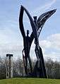
Phoenix Trees | Bowman's Island, at junction with Wednesfield Way – Planetary Road, Wednesfield 52.594524°N 2.092284°W |
2001 | Steve Geliot | Sculpture | Oaks & cast metal, bronze coloured | Poles: 5m high | Wolverhampton City Council | [53][54] | |
 More images |
Past Present Future | Sainsbury's – Kenmare Way, Wednesfield 52.597598°N 2.085724°W approx |
2013 | Planet Art (Julie Edwards & Ron Thompson) | Sculpture | Stainless steel | 2 screens – both 7m x 4m | Wolverhampton City Council | [25] | |
 |
Wednesfield Mural | Bealeys Fold, Wednesfield (off the High Street) 52.599938°N 2.081944°W approx |
1960s | Mosaic mural | tiles | Wolverhampton City Council | Mural by local school[55] |
References
| Wikimedia Commons has media related to Public art in Wolverhampton. |
- Historic England. "Prince Albert Statue (Grade II) (1201858)". National Heritage List for England. Retrieved 12 March 2015.
- "PMSA". pmsa.org.uk. Archived from the original on 2 April 2015.
- Historic England. "Lloyds Bank (Grade II) (1279604)". National Heritage List for England. Retrieved 25 March 2015.
- "PMSA". pmsa.org.uk. Archived from the original on 2 April 2015.
- "PMSA". pmsa.org.uk. Archived from the original on 2 April 2015.
- Historic England. "Harris Memorial (St Peter's Gardens) (Grade II) (1355124)". National Heritage List for England. Retrieved 12 March 2015.
- "PMSA". pmsa.org.uk. Archived from the original on 2 April 2015.
- "PMSA". pmsa.org.uk. Archived from the original on 2 April 2015.
- Historic England. "Art Gallery and Museum (Grade II*) (1201828)". National Heritage List for England. Retrieved 25 March 2015.
- "PMSA". pmsa.org.uk. Archived from the original on 24 September 2015.
- "PMSA". pmsa.org.uk. Archived from the original on 2 April 2015.
- "PMSA". pmsa.org.uk. Archived from the original on 2 April 2015.
- "Signal Man". Art Map Wolverhampton. Archived from the original on 2 April 2015.
- "Mick Thacker". axisweb.org.
- "Locomotion 2". Art Map Wolverhampton. Archived from the original on 2 April 2015. Retrieved 26 March 2015.
- "Echelon with Concrete Pillars". Art Map Wolverhampton. Archived from the original on 17 March 2015. Retrieved 12 March 2015.
- "PMSA". pmsa.org.uk. Archived from the original on 24 September 2015.
- "Billy Wright Statue". Art Map Wolverhampton. Archived from the original on 6 May 2012.
- "Wolves legend Billy Wright's statue smashed in car crash". bbc.co.uk/news. Retrieved 16 January 2017.
- "Stan Cullis". Offbeat Group. Retrieved 26 March 2019.
- "Wolves unveil statue of Sir Jack Hayward". bbc.co.uk/news. Retrieved 14 June 2018.
- "City Gateway". Julia Rowley Glass.
- Noszlopy, George Thomas; Waterhouse, Fiona (1 January 2005). Public Sculpture of Staffordshire and the Black Country. Liverpool University Press. ISBN 9780853239895.
- "PMSA". pmsa.org.uk. Archived from the original on 2 April 2015.
- "Planet Art CV" (PDF). Planet Art Sculpture. Archived from the original (PDF) on 2 April 2015. Retrieved 25 March 2015.
- Historic England. "Villiers Statue (Grade II) (1201900)". National Heritage List for England. Retrieved 27 March 2019.
- "The Lone Rider". The Lone Rider. Public Monuments and Sculpture Association. Archived from the original on 20 October 2013. Retrieved 19 October 2013.
- "Reflective Metal Bridge". Art Map Wolverhampton. Archived from the original on 16 March 2015. Retrieved 25 March 2015.
- "PMSA". pmsa.org.uk. Archived from the original on 2 April 2015. Retrieved 26 March 2015.
- "PMSA". pmsa.org.uk. Archived from the original on 2 April 2015.
- "PMSA". pmsa.org.uk. Archived from the original on 2 April 2015.
- "Banners Seats Markers – Bilston". Chrysalis Arts.
- ""Women's Work" 1996 - 1998". Rose Garrard. Retrieved 14 January 2018.
- "Womens Work". Art Map Wolverhampton. Archived from the original on 20 March 2015.
- "PMSA". pmsa.org.uk. Archived from the original on 2 April 2015.
- "PMSA". pmsa.org.uk. Archived from the original on 24 September 2015.
- "Bilston Job Centre facade". John McKenna A4A.
- "Witness, 1997". Bettina Furnee. Retrieved 13 January 2018.
- "Witness". Art Map Wolverhampton. Archived from the original on 17 March 2015.
- "Hovering Kestrel". John McKenna A4A.
- "PMSA". pmsa.org.uk. Archived from the original on 24 September 2015.
- "PMSA". pmsa.org.uk. Archived from the original on 2 April 2015.
- "Steel Monoliths". Art Map Wolverhampton. Archived from the original on 19 March 2015.
- "PMSA". pmsa.org.uk. Archived from the original on 2 April 2015.
- "Tower of Light". Art Map Wolverhampton. Archived from the original on 28 May 2014.
- "Beth's Arch". Art Map Wolverhampton. Archived from the original on 2 April 2015.
- "PMSA". pmsa.org.uk. Archived from the original on 2 April 2015.
- "PMSA". pmsa.org.uk. Archived from the original on 2 April 2015.
- "Black Country Route". Richard Criddle Sculpture. Retrieved 15 January 2018.
- "Special Feature Project". Art Map Wolverhampton. Archived from the original on 17 March 2015.
- "Lighting". Circling the Square. Retrieved 14 January 2018.
- "Night Swimmer". Art Map Wolverhampton. Archived from the original on 17 March 2015. Retrieved 25 March 2015.
- "5 Tree-lined Avenue". Art Map Wolverhampton. Archived from the original on 2 April 2015. Retrieved 26 March 2015.
- "PMSA". pmsa.org.uk. Archived from the original on 2 April 2015.
- "Wednesfield Mural – Bealeys Fold". geograph.org.uk.
Public art and memorials in the United Kingdom | ||||||
|---|---|---|---|---|---|---|
| England |
|  | ||||
| Northern Ireland | ||||||
| Scotland |
| |||||
| Wales | ||||||
| Lists by type | ||||||
| Organisations | ||||||
| Projects | ||||||
This article is issued from Wikipedia. The text is licensed under Creative Commons - Attribution - Sharealike. Additional terms may apply for the media files.