List of national parks of Finland

There are 40 national parks in Finland. They are all managed by the Metsähallitus. The national parks cover a total area of 9,892 square kilometres (3,819 sq mi) – 2.7% of Finland's total land area.

A total of 3.2 million people visited the parks in 2018.[1]

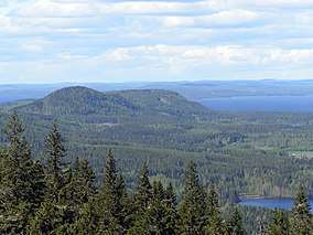
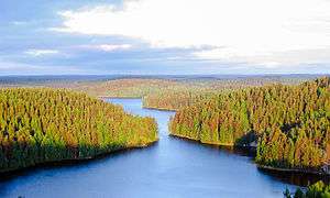
Lake Pielinen seen from a hill in Koli National Park.

List of national parks

National park Photo Region Land area (km²) Established Visitation (2009)[2] Coordinates
Archipelago Southwest Finland 500 1982 53,500 59°54′53″N 21°52′39″E
Bothnian Bay Lapland 2.5 1991 9,000 65°37′N 024°19′E
Teijo Southwest Finland 33.85 2015 79,700(2015) 60°13′26″N 022°57′37″E
Bothnian Sea Southwest Finland & Satakunta 913 2011 87,900 61°32′06″N 21°33′50″E
Eastern Gulf of Finland Kymenlaakso 6.7 1982 19,000 60°17′5″N 27°16′26″E
Ekenäs Archipelago Uusimaa 52 1989 44,500 59°49′22″N 23°27′15″E
Helvetinjärvi Pirkanmaa 49.8 1982 33,000 62°2′N 23°51′E
Hiidenportti Kainuu 45 1982 12,000 63°52′22″N 29°3′31″E
Hossa Kainuu 11 2017 58,000 65°29′23″N 29°19′25″E
Isojärvi Central Finland 19 1982 10,500 61°41′54″N 25°0′39″E
Kauhaneva-Pohjankangas Southern Ostrobothnia / Satakunta 57 1982 4,500 62°10′45″N 22°24′23″E
Koli North Karelia 30 1991 127,500 63°3′27″N 29°53′14″E
Kolovesi Southern Savonia 23 1990 7,500 62°15′27″N 28°49′0″E
Southern Konnevesi[3] Central Finland / Northern Savonia 15.44 2014 62°33′30″N 26°38′50″E
Kurjenrahka Southwest Finland 29 1998 28,500 60°43′14″N 22°23′1″E
Lauhanvuori Southern Ostrobothnia 53 1982 10,000 62°09′7″N 22°10′30″E
Leivonmäki Central Finland 29 2003 12,500 61°56′N 26°2′E
Lemmenjoki Lapland 2,850 1956 10,000 68°30′N 25°30′E
Liesjärvi Tavastia Proper 22 1956 30,500 60°40′50″N 23°51′30″E
Linnansaari Southern Savonia / Northern Savonia 38 1956 31,000 62°6′38″N 28°30′34″E
Nuuksio Uusimaa 45 1994 179,500 60°18′27″N 24°29′57″E
Oulanka Northern Ostrobothnia / Lapland 270 1956 165,500 66°22′32″N 29°20′19″E
Päijänne Päijänne Tavastia 14 1993 15,000 61°23′12″N 25°23′36″E
Pallas-Yllästunturi Lapland 1,020 2005 419,000 68°9′32″N 24°2′25″E
Patvinsuo North Karelia 105 1982 12,000 63°6′41″N 30°42′16″E
Petkeljärvi North Karelia 6 1956 19,500 62°35′N 31°11′E
Puurijärvi-Isosuo Pirkanmaa / Satakunta 27 1993 11,500 61°14′57″N 22°34′1″E
Pyhä-Häkki Central Finland 13 1956 17,000 62°50′44″N 25°28′21″E
Pyhä-Luosto Lapland 142 2005 128,000 67°3′59″N 26°58′25″E
Repovesi Kymenlaakso / Southern Savonia 15 2003 74,500 61°11′N 26°53′E
Riisitunturi Lapland 77 1982 15,000 66°14′N 28°30′E
Rokua Northern Ostrobothnia / Kainuu 4.3 1956 23,500 64°33′22″N 26°30′36″E
Salamajärvi Central Ostrobothnia / Central Finland 62 1982 10,500 63°16′N 24°45′E
Seitseminen Pirkanmaa 45.5 1982 45,500 61°56′N 23°26′E
Sipoonkorpi Uusimaa 18.6 2011 60°18′54″N 25°13′8″E
Syöte Northern Ostrobothnia / Lapland 299 2000 40,000 65°44′51″N 27°54′43″E
Tiilikkajärvi Northern Savonia / Kainuu 34 1982 7,500 63°40′N 28°18′E
Torronsuo Tavastia Proper 25.5 1990 20,500 60°44′N 23°37′E
Urho Kekkonen Lapland 2,550 1983 289,000 68°13′5″N 28°8′25″E
Valkmusa Kymenlaakso 17 1996 7,000 60°34′N 26°44′E

See also

Other references on Wikipedia:

References

  1. "The economic and health impacts of Finnish national parks increased in 2018 – positive development at risk without increase in funding". Metsähallitus. 2019-01-31. Retrieved January 31, 2019.
  2. "Käyntimäärät kansallispuistoittain 2009" (in Finnish). Metsähallitus. Retrieved September 29, 2010.
  3. Outdoors.fi. Retrieved 2015-04-26. (in English)
This article is issued from Wikipedia. The text is licensed under Creative Commons - Attribution - Sharealike. Additional terms may apply for the media files.