List of listed buildings in Troon, South Ayrshire
List
| Name | Location | Date Listed | Grid Ref. [note 1] | Geo-coordinates | Notes | LB Number [note 2] | Image |
|---|---|---|---|---|---|---|---|
| 116, 118 And 120 Welbeck Crescent Including Boundary Wall And Piers | 55°32′33″N 4°40′19″W | Category C(S) | 45264 |  | |||
| 9 And 11 Yorke Road Including Boundary Wall | 55°32′21″N 4°39′17″W | Category C(S) | 45265 | | |||
| 25A, 25B And 25C Bentinck Drive, Brandon House Including Boundary Wall | 55°32′29″N 4°39′24″W | Category C(S) | 45246 | | |||
| 137 Bentinck Drive, Rowallan, Including Boundary Wall And Gatepiers | 55°32′04″N 4°38′54″W | Category C(S) | 45247 | | |||
| 11 Crosbie Road, Mokoia, Including Terrace, Boundary Wall And Gatepiers | 55°31′48″N 4°38′48″W | Category C(S) | 45253 | | |||
| Bentinck Drive, St Ninian's Episcopal Church Including Lych Gate, Rear Boundary Wall And Piers | 55°32′17″N 4°39′10″W | Category B | 42109 | | |||
| 134 Bentinck Drive, Scotswood, Including Boundary Walls, Gatepiers And Gates | 55°32′04″N 4°38′59″W | Category C(S) | 42110 | | |||
| Dundonald Road, Lodge At Entrance To Marr College | 55°32′47″N 4°38′44″W | Category C(S) | 42117 | | |||
| Isle Of Pin Road, Fullarton Courtyard Including Sundial | 55°32′13″N 4°37′27″W | Category B | 42121 | | |||
| Monktonhill Road, Ruins Of Crosbie Church And Churchyard Including Boundary Wall, Gatepiers And Gates | 55°31′51″N 4°37′30″W | Category B | 42123 | | |||
| South Beach, Town Hall Including Lamp Standards | 55°32′33″N 4°39′46″W | Category B | 42136 | | |||
| 48, 48A And 50 South Beach Including Boundary Walls | 55°32′25″N 4°39′29″W | Category C(S) | 42144 | | |||
| 56 South Beach, Elmslie, Including Boundary Walls, Gatepiers, Former Gig-House And 2A Victoria Drive, Groom Cottage | 55°32′22″N 4°39′27″W | Category B | 42145 | | |||
| 79 South Beach, Cairnsaigh Including Boundary Wall And Gatepiers | 55°32′18″N 4°39′16″W | Category C(S) | 45261 | | |||
| 70 Bentinck Drive, St Ninian's Rectory Including Boundary Wall | 55°32′19″N 4°39′13″W | Category C(S) | 45249 | | |||
| 130 And 130A Bentinck Drive, Terrydale And Kirkland, Including Boundary Wall And Piers | 55°32′06″N 4°39′00″W | Category C(S) | 45250 | | |||
| 40 And 42 Bradan Road Including Outbuilding | 55°32′38″N 4°40′07″W | Category C(S) | 45251 | | |||
| 15 Crosbie Road, Including Sunken Garden Walls, Boundary Wall And Gatepiers | 55°31′46″N 4°38′46″W | Category C(S) | 45254 | | |||
| Fullarton Park, Gatepiers And Outer Piers (4 Pins) Original East Entrance To Fullarton House | 55°32′11″N 4°37′17″W | Category C(S) | 45256 | | |||
| 69 And 71 Portland Street, Mckays Public House | 55°32′43″N 4°39′42″W | Category C(S) | 45258 | | |||
| 2 Bentinck Drive, Advie Lodge And 12 St Meddans Street, Including Boundary Walls | 55°32′33″N 4°39′33″W | Category B | 42107 | | |||
| Isle Of Pin Road, Fullarton Park, Two Pedestals At Site Of Former Fullarton House | 55°32′14″N 4°37′27″W | Category B | 42122 | | |||
| 125 And 125A Portland Street Including Boundary Wall And Piers | 55°32′48″N 4°39′31″W | Category C(S) | 42124 | | |||
| 4 Cessnock Road, Roman Catholic Presbytery Adjoining Church Of Our Lady Of The Assumption And St Meddan, St Meddans Street | 55°32′41″N 4°39′12″W | Category B | 42130 | | |||
| 1 South Beach And 6 Academy Street | 55°32′34″N 4°39′44″W | Category C(S) | 42131 | | |||
| 117 South Beach, Including Boundary Wall, Entrance Arch And Gatepiers | 55°32′10″N 4°39′10″W | Category B | 42132 | | |||
| 135 And 137 South Beach Including Boundary Wall And Gatepiers | 55°32′05″N 4°39′07″W | Category C(S) | 42134 | | |||
| 30 And 30A South Beach, Craigronach And Fin Me Oot, Including Boundary Walls | 55°32′29″N 4°39′37″W | Category B | 42140 | | |||
| 68 And 68A South Beach, Loanhead, Including Boundary Walls | 55°32′19″N 4°39′22″W | Category B | 42147 | | |||
| 17 Crosbie Road, Cessford, Including Sunken Garden Walls, Boundary Wall And Gatepiers | 55°31′44″N 4°38′43″W | Category B | 42161 | | |||
| 3 Craigend Road, Belhaven Nursing Home Including Boundary Wall, Railings And Piers | 55°32′00″N 4°38′59″W | Category C(S) | 45252 | | |||
| 19 Crosbie Road, Real Tennis Court Adjoining Sun Court Nursing Home | 55°31′43″N 4°38′39″W | Category C(S) | 45255 | | |||
| Isle Of Pin Road, Stone Pillar (Within Boundary Of Monkland) | 55°32′09″N 4°37′51″W | Category C(S) | 45257 | | |||
| 15 Craigend Road, Piersland House Hotel (Formerly Piersland Lodge), Including Summer Houses, Terrace And Columns | 55°32′02″N 4°38′49″W | Category A | 42114 | | |||
| Crosbie Road, Puma Hotels Collection's The Marine Hotel Including Terrace Wall, Piers And Gate | 55°31′54″N 4°38′55″W | Category C(S) | 42115 | | |||
| Dundonald Road, Four Gatepiers At Entrance To Marr College | 55°32′43″N 4°38′44″W | Category C(S) | 42118 | | |||
| Dundonald Road, Former Janitor's House, Marr College | 55°32′54″N 4°38′41″W | Category C(S) | 42119 | | |||
| St Meddans Street, Catholic Church Of Our Lady Of The Assumption And St Meddan Including Passage And Boundary Wall | 55°32′42″N 4°39′13″W | Category A | 42129 | 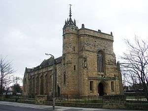 | |||
| 26 South Beach, Inchanga, Including Boundary Walls And Piers | 55°32′30″N 4°39′39″W | Category C(S) | 42138 | | |||
| 70 And 70A South Beach | 55°32′18″N 4°39′20″W | Category C(S) | 42148 | | |||
| 1 Wood Road, Former Miners' Institute Including Boundary Wall And Piers | 55°32′35″N 4°40′22″W | Category C(S) | 42159 | | |||
| 55 And 55A St Meddans Street Including Boundary Wall And Gatepiers | 55°32′42″N 4°39′20″W | Category C(S) | 45260 | | |||
| 10 Victoria Drive Including Boundary Walls | 55°32′25″N 4°39′21″W | Category C(S) | 45263 | | |||
| 10 And 12 Yorke Road Including Boundary Wall | 55°32′19″N 4°39′14″W | Category C(S) | 45266 | | |||
| 51-59 (Odd Nos) Ayr Street And 5 And 7 Academy Street, Including The Royal Bank Of Scotland | 55°32′35″N 4°39′45″W | Category B | 45242 | | |||
| Barassie Street, Troon Primary School Including No 39 Barassie Street (Janitors House), Outbuildings, Boundary Walls, Railings, Gatepiers And Gates | 55°32′43″N 4°39′30″W | Category C(S) | 45243 | | |||
| 58 Bentinck Drive, The Hermitage, Including Boundary Wall And Gatepiers | 55°32′21″N 4°39′15″W | Category C(S) | 45248 | | |||
| Ayr Street, Troon Old Parish Church (Church Of Scotland) Including Boundary Walls, Gatepiers And Gates | 55°32′34″N 4°39′48″W | Category B | 42102 | | |||
| 121 And 121A Bentinck Drive Including Boundary Wall, Entrance Gateway And Piers | 55°32′10″N 4°38′59″W | Category C(S) | 42104 | | |||
| 133 And 135 Bentinck Drive And 37 Bentinck Crescent Including Boundary Wall, Entrance Arches And Gates | 55°32′04″N 4°38′55″W | Category C(S) | 42105 | | |||
| 139-145 (Odd Nos) Bentinck Drive, Piersland Mews Including Boundary Wall And Piers | 55°32′03″N 4°38′54″W | Category C(S) | 42106 | | |||
| 82, 84 And 86 Portland Street | 55°32′43″N 4°39′38″W | Category C(S) | 42125 | | |||
| St Meddans Street, Portland Church (Church Of Scotland) And Church Halls Including Boundary Wall, Piers And Gates | 55°32′31″N 4°39′36″W | Category B | 42128 | | |||
| 58 Alton Lodge And 60 South Beach Including Boundary Walls And Piers | 55°32′22″N 4°39′25″W | Category C(S) | 42146 | | |||
| 93 And 95 Templehill | 55°32′39″N 4°40′03″W | Category B | 42152 | | |||
| West Portland Street, Seagate Evangelical Church, Former Bethany Chapel | 55°32′35″N 4°39′53″W | Category B | 42158 | | |||
| Troon Harbour Including North Pier, Harbour Walls, Graving Docks And Wet Dock | 55°32′52″N 4°40′50″W | Category B | 45262 | | |||
| Bentinck Crescent, Shandwick, Including Boundary Wall, Piers And Gates | 55°32′11″N 4°38′47″W | Category C(S) | 45245 | | |||
| 9 Craigend Road, Piersland Gatehouse, Former West Lodge To Piersland Lodge (Now Piersland House Hotel), Including Boundary Wall, Piers And Gatepiers | 55°32′00″N 4°38′54″W | Category B | 42113 | | |||
| St Meddans Street, St Meddans Parish Church (Church Of Scotland) And Church Hall Including Boundary Wall And Piers | 55°32′34″N 4°39′36″W | Category B | 42126 | | |||
| 28 South Beach, Dolphin Cottage, Including Boundary Walls | 55°32′30″N 4°39′38″W | Category C(S) | 42139 | | |||
| 149 Templehill, Anchorage Hotel | 55°32′39″N 4°40′10″W | Category C(S) | 42153 | | |||
| Harbour Road, Retail Premises And Dwellings, Former Harbour Office And Custom House, Including Rear Walls | 55°32′53″N 4°41′04″W | Category C(S) | 42156 | | |||
| Troon Railway Station | 55°32′34″N 4°39′19″W | Category B | 42157 | | |||
| 46 South Beach Including Boundary Walls And Piers | 55°32′25″N 4°39′30″W | Category B | 42143 | | |||
| Ayr Street, Former Parish Church, Now Old Parish Church Hall Including Boundary Wall | 55°32′35″N 4°39′49″W | Category B | 42101 | | |||
| 2 Craigend Road, Royal Troon Golf Club Including Boundary Walls And Gatepiers | 55°31′58″N 4°39′03″W | Category C(S) | 42112 | | |||
| Dundonald Road, Marr College (Main Block) Including Front Terrace Walls, Lamp Standards And Steps | 55°32′56″N 4°38′43″W | Category B | 42116 | | |||
| South Beach, Crosbie Tower Including Conservatory, Boundary Wall, Piers And Gates | 55°32′03″N 4°39′06″W | Category B | 42135 | | |||
| 36 South Beach Including Boundary Walls | 55°32′27″N 4°39′33″W | Category C(S) | 42141 | | |||
| 155 Templehill, Bank House Including Boundary Walls And Piers | 55°32′39″N 4°40′12″W | Category B | 42154 | | |||
| 41 Barassie Street, Former Tinnion Nursing Home, Including Boundary Wall, Gatepiers And Gates | 55°32′41″N 4°39′31″W | Category C(S) | 45244 | | |||
| 127, 129 And 131 Portland Street Including Boundary Wall And Piers | 55°32′49″N 4°39′30″W | Category C(S) | 45259 | | |||
| 64 Bentinck Drive, Welbeck House Including Boundary Walls And Piers | 55°32′20″N 4°39′13″W | Category B | 42108 | | |||
| Isle Of Pin Road, Fullarton Park, Grotto | 55°32′19″N 4°37′26″W | Category B | 42120 | | |||
| 85 St Meddans Street, Stanmore, Including Boundary Wall And Gate | 55°32′45″N 4°39′12″W | Category C(S) | 42127 | | |||
| South Beach Esplanade, War Memorial[1] | 55°32′31″N 4°39′45″W[2]) | Category B | 42137 | 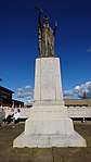 | |||
| 72 South Beach, Including Boundary Walls | 55°32′17″N 4°39′20″W | Category B | 42149 | | |||
| 74 South Beach, Arranview, Including Boundary Walls | 55°32′17″N 4°39′19″W | Category B | 42150 | | |||
| 76 And 76A South Beach, Including Boundary Walls | 55°32′16″N 4°39′18″W | Category B | 42151 | |
Key
The scheme for classifying buildings in Scotland is:
- Category A: "buildings of national or international importance, either architectural or historic; or fine, little-altered examples of some particular period, style or building type."[4]
- Category B: "buildings of regional or more than local importance; or major examples of some particular period, style or building type, which may have been altered."[4]
- Category C: "buildings of local importance; lesser examples of any period, style, or building type, as originally constructed or moderately altered; and simple traditional buildings which group well with other listed buildings."[4]
In March 2016 there were 47,288 listed buildings in Scotland. Of these, 8 per cent were Category A, and 50 per cent were Category B, with the rest listed at Category C.[5]
Notes
- Sometimes known as OSGB36, the grid reference (where provided) is based on the British national grid reference system used by the Ordnance Survey.
• "Guide to National Grid". Ordnance Survey. Retrieved 12 December 2007.
• "Get-a-map". Ordnance Survey. Retrieved 17 December 2007. - Historic Environment Scotland assign a unique alphanumeric identifier to each designated site in Scotland, for listed buildings this always begins with "LB", for example "LB12345".
References
- All entries, addresses and coordinates are based on data from Historic Scotland. This data falls under the Open Government Licence
- "Troon". Imperial War Museums.
- "Troon". Imperial War Museums.
- "Troon". Imperial War Museums.
- "What is Listing?". Historic Environment Scotland. Retrieved 29 May 2018.
- Scotland's Historic Environment Audit 2016 (PDF). Historic Environment Scotland and the Built Environment Forum Scotland. pp. 15–16. Retrieved 29 May 2018.
This article is issued from Wikipedia. The text is licensed under Creative Commons - Attribution - Sharealike. Additional terms may apply for the media files.