List of listed buildings in Northmavine, Shetland Islands
List
| Name | Location | Date Listed | Grid Ref. [note 1] | Geo-coordinates | Notes | LB Number [note 2] | Image |
|---|---|---|---|---|---|---|---|
| North Roe Post Office | 60°34′44″N 1°19′57″W | Category C(S) | 44560 | 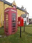 | |||
| Hillswick, Northmavine Kirk, Including Kirkyard Wall, Gate, And Gatepiers | 60°28′37″N 1°29′13″W | Category B | 19900 | 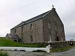 | |||
| Ollaberry, Ollaberry Kirkyard Monument | 60°30′25″N 1°20′02″W | Category B | 18687 |  | |||
| Hillswick, Hillswick House, Including Gatepiers, Outbuildings, Cottage, Garden And Boundary Walls | 60°28′34″N 1°29′19″W | Category B | 18688 | | |||
| Ollaberry, Ollaberry Bods, Including Retaining Wall And Steps | 60°30′25″N 1°20′08″W | Category C(S) | 44563 | | |||
| North Roe Methodist Church, Including Railings | 60°34′46″N 1°19′58″W | Category C(S) | 44558 | .jpg) | |||
| North Roe, Telephone Kiosk | 60°34′44″N 1°19′57″W | Category B | 44561 | | |||
| Ollaberry, Bardister Haa, With Outbuilding And Garden Walls | 60°28′45″N 1°20′51″W | Category B | 44562 | | |||
| Hamnavoe, Johnny 'Notion' Williamson's House, Including Outbuildings | 60°30′30″N 1°34′11″W | Category C(S) | 18692 | 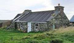 | |||
| North Roe, North Haa, Including Walls And Outbuildings | 60°35′09″N 1°19′55″W | Category C(S) | 44559 | | |||
| Hillswick, St Magnus Bay Hotel | 60°28′36″N 1°29′17″W | Category C(S) | 18689 | 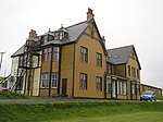 | |||
| Tangwick, Haa Of Tangwick, Including Walled Garden | 60°28′56″N 1°34′44″W | Category B | 18690 | 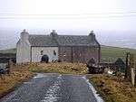 | |||
| Eshaness, Eshaness Lighthouse, Including Oil Tank, Sundial, And Gates | 60°29′21″N 1°37′38″W | Category B | 44556 | 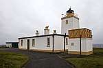 | |||
| North Roe, Lochend House, Including Outbuilding And Garden Wall | 60°32′25″N 1°19′49″W | Category C(S) | 44557 | | |||
| Stenness, Stenness Fishing Station Bod | 60°28′38″N 1°36′42″W | Category C(S) | 44565 | 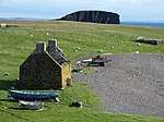 | |||
| Ollaberry, Ollaberry Pier, Including Derrick And Walls | 60°30′23″N 1°20′09″W | Category B | 44564 | 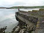 | |||
| Hillswick, Northmavine Manse, Including Garden And Boundary Walls And Outbuildings | 60°28′26″N 1°29′24″W | Category B | 18686 | 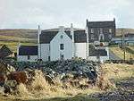 | |||
| Ollaberry, Ollaberry House (Haa Of Ollaberry), Including Outbuilding And Boundary Walls | 60°30′25″N 1°20′10″W | Category B | 18691 | |
Key
The scheme for classifying buildings in Scotland is:
- Category A: "buildings of national or international importance, either architectural or historic; or fine, little-altered examples of some particular period, style or building type."[1]
- Category B: "buildings of regional or more than local importance; or major examples of some particular period, style or building type, which may have been altered."[1]
- Category C: "buildings of local importance; lesser examples of any period, style, or building type, as originally constructed or moderately altered; and simple traditional buildings which group well with other listed buildings."[1]
In March 2016 there were 47,288 listed buildings in Scotland. Of these, 8 per cent were Category A, and 50 per cent were Category B, with the rest listed at Category C.[2]
Notes
- Sometimes known as OSGB36, the grid reference (where provided) is based on the British national grid reference system used by the Ordnance Survey.
• "Guide to National Grid". Ordnance Survey. Retrieved 12 December 2007.
• "Get-a-map". Ordnance Survey. Retrieved 17 December 2007. - Historic Environment Scotland assign a unique alphanumeric identifier to each designated site in Scotland, for listed buildings this always begins with "LB", for example "LB12345".
References
- All entries, addresses and coordinates are based on data from Historic Scotland. This data falls under the Open Government Licence
- "What is Listing?". Historic Environment Scotland. Retrieved 29 May 2018.
- Scotland's Historic Environment Audit 2016 (PDF). Historic Environment Scotland and the Built Environment Forum Scotland. pp. 15–16. Retrieved 29 May 2018.
This article is issued from Wikipedia. The text is licensed under Creative Commons - Attribution - Sharealike. Additional terms may apply for the media files.