List of drainage basins of Australia
A drainage basin is an extent of land where water from rain and melting snow or ice drains downhill into a body of water, such as a river, lake, reservoir, estuary, wetland, sea or ocean. The drainage basin includes both the streams and rivers that convey the water as well as the land surfaces from which water drains into those channels, and is separated from adjacent basins by a drainage divide.
Australia has thirteen distinguished drainage divisions[1] as defined by the Australian Water Resources Assessment 2012, a hydrological survey conducted by the Bureau of Meteorology.[2] Runoff from these divisions generally flows into the Pacific Ocean, the Indian Ocean, the Southern Ocean and Lake Eyre.
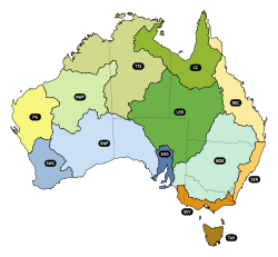
Australia's 13 drainage divisions
List of drainage basins
- A ^ New drainage basin codes assigned by the Bureau of Meteorology in 2010. Previous codes were labelled using Roman Numerals. See for details.
- B ^ Long term average from July 1911 to June 2010
- C ^ The obsolete Australia River Basins 1997 survey listed the Bulloo-Bancannia drainage basin as a separate division, but has now been combined with the Lake Eyre Basin.
- D ^ Known in Queensland as Gulf Basin[4]
See also
- List of reservoirs and dams in Australia
- List of rivers of Australia
- Geography of Australia
- Climate change in Australia
- Drought in Australia
- Great Artesian Basin
References
- "Australia's water resources". State of the Environment 2016. Australian Government, Department of the Environment and Energy. Retrieved 19 June 2019.
- "Australian Water Resources Assessment 2012" (PDF). Bureau of Meteorology. Retrieved 19 June 2019.
- "Water Storage". Bureau of Meteorology. Retrieved 19 June 2019.
- "Queensland Globe". State of Queensland. Retrieved 23 July 2019.
This article is issued from Wikipedia. The text is licensed under Creative Commons - Attribution - Sharealike. Additional terms may apply for the media files.