List of crossings of the North Saskatchewan River
This is a list of crossings of the North Saskatchewan River in the Canadian provinces of Saskatchewan and Alberta from the river's confluence with the South Saskatchewan River upstream to its source.
Tables
Saskatchewan
Alberta
| Crossing | Carries | Location | Notes | Completion Date | Coordinates |
|---|---|---|---|---|---|
| Highway bridge | SK Highway 17 AB Highway 17 |
south of Onion Lake | 1985 | 53.603°N 110.012°W | |
| Highway bridge | Highway 897 | north of Marwayne | 1957 | 53.660°N 110.336°W | |
| Highway bridge | Highway 893 | south of Heinsburg | 1961 | 53.771°N 110.533°W | |
| Highway bridge | Highway 41 | south of Elk Point | 1983 | 53.862°N 110.897°W | |
| Highway bridge | Highway 881 | south of St. Paul | 1970 | 53.755°N 111.222°W | |
| Highway bridge | Highway 36 | Brosseau to Duvernay | 53.790°N 111.689°W | ||
| Highway bridge | Highway 857 | north of Willingdon | 1962 | 53.975°N 112.150°W | |
| Highway bridge | Highway 855 | south of Smoky Lake | 1972 | 53.990°N 112.476°W | |
| Highway bridge | Highway 831 | south of Waskatenau | 1963 | 54.060°N 112.780°W | |
| Vinca Bridge | Highway 38 | southeast of Redwater | 1967 | 53.888°N 112.974°W | |
| Railway bridge | CN Railway | west of Scotford | 53.761°N 113.171°W | ||
| Highway bridge | Highway 15 | Fort Saskatchewan | 1957 | 53.706°N 113.235°W | |
| Highway bridge | Highway 216[lower-alpha 1] | Edmonton | two spans, 7 lanes |
2016 | 53.608°N 113.354°W |
| Clover Bar Railway Bridge | CN Railway | 1908 | 53.573°N 113.372°W | ||
| Clover Bar Bridge | Highway 16 | 3 lanes eastbound | 1953 | 53.572°N 113.372°W | |
| Beverly Bridge | 3 lanes westbound | 1972 | 53.571°N 113.373°W | ||
| Rundle Park Footbridge | Pedestrians and cyclists | 53.563°N 113.379°W | |||
| Ainsworth Dyer Footbridge | Pedestrians and cyclists | 53.554°N 113.398°W | |||
| Capilano Footbridge | Pedestrians and cyclists | 53.563°N 113.419°W | |||
| Capilano Bridge | Wayne Gretzky Drive | 6 lanes | 1969 | 53.556°N 113.439°W | |
| Dawson Bridge | Rowland Road | 2 lanes | 1912 | 53.549°N 113.467°W | |
| Tawatinâ Bridge | Edmonton LRT | Edmonton LRT (Valley Line) | Planned 2020 | 53.5401°N 113.4772°W | |
| Low Level Bridge | Rossdale Road to Connors Road & Scona Road | twin spans, 4 lanes | 1900 | 53.538°N 113.487°W | |
| James MacDonald Bridge | 97 Avenue to 98 Avenue | 4 lanes | 1971 | 53.536°N 113.488°W | |
| Walterdale Bridge (formerly 105 Street Bridge) |
105 Street | 2 lanes northbound | 1914 | 53.529°N 113.502°W | |
| High Level Bridge | 109 Street, High Level Bridge Streetcar | 2 lanes southbound | 1913 | 53.531°N 113.511°W | |
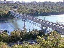
| Dudley B. Menzies Bridge | Edmonton LRT | 2 tracks | 1989 | 53.531°N 113.512°W | |
| Groat Bridge | Groat Road | 4 lanes | 1955 | 53.537°N 113.539°W | |
| Buena Vista / Hawrelak Park Footbridge | Pedestrians and cyclists | 53.523°N 113.547°W | |||
| Quesnell Bridge | Whitemud Drive (Highway 2) |
8 lanes | 1968 | 53.507°N 113.567°W | |
| Fort Edmonton Footbridge | Pedestrians and cyclists | 2010 | 53.495°N 113.590°W | ||
| Terwillegar Park Footbridge | Pedestrians and cyclists | 2016 | 53.481°N 113.598°W | ||
| Highway bridge | Highway 216[lower-alpha 1] | twin spans, 4 lanes | 2005 | 53.460°N 113.615°W | |
| Devon Bridge | Highway 60 | Devon | twin spans, 4 lanes | 1986 | 53.370°N 113.752°W |
| Highway bridge | Highway 770 | northeast of Genesee | 1966 | 53.377°N 114.279°W | |
| Highway bridge | Highway 759 | south of Tomahawk | 1981 | 53.315°N 114.758°W | |
| Highway bridge | Highway 22 | east of Drayton Valley | 1957 | 53.206°N 114.929°W | |
| Highway bridge | Highway 11 | Rocky Mountain House | 1971 | 52.410°N 114.954°W | |
| Highway bridge | Highway 11A | 2005 | 52.376°N 114.937°W | ||
| Railway bridge | CN Railway | 52.375°N 114.941°W | |||
| Highway bridge | Highway 734 | southwest of Nordegg | 1926 | 52.396°N 116.075°W | |
| Bighorn Dam | Range Road 171A or Jackpine Road | southwest of Nordegg, northern Abraham Lake | Two crossings of two arms, one being seasonal. Hydroelectric dam that creates Abraham lake. |
1972 | 52°19′36″N 116°19′56″W and 52°18′32″N 116°19′47″W |
| Highway bridge | Highway 93 | Saskatchewan River Crossing | 51.970°N 116.721°W |
Notes
- The southbound bridge at both crossings of Highway 216 also carries a pedestrian/bicycle path underneath the highway lanes.
References
- "Transportation Infrastructure Management System - Existing Structures in the Provincial Highway Corridor" (PDF). Alberta Transportation. September 28, 2012. Retrieved November 22, 2016.
- Google (November 17, 2016). "North Saskatchewan River in Western Canada" (Map). Google Maps. Google. Retrieved November 17, 2016.
This article is issued from Wikipedia. The text is licensed under Creative Commons - Attribution - Sharealike. Additional terms may apply for the media files.