List of canal aqueducts in the United Kingdom
This list of canal aqueducts in the United Kingdom covers aqueducts that have articles in Wikipedia. The actual number of canal aqueducts is much greater.
| Aqueduct | Canal | Designer | Coordinates | Notes | Image |
|---|---|---|---|---|---|
| Almond Aqueduct | Union Canal | 55.9212°N 3.4337°W | Aqueduct over the River Almond | 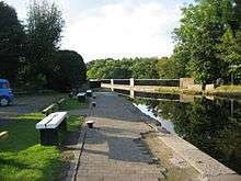 Almond Aqueduct, Scotland | |
| Ariel Aqueduct | Worcester and Birmingham Canal | 52.4470°N 1.9378°W | Aqueduct over the Aston Webb Boulevard (Selly Oak Bypass) in Selly Oak, Birmingham, opened in 2011. | .jpg) Ariel Aqueduct | |
| Avon Aqueduct | Union Canal | 55.9701°N 3.6496°W | Scotland's longest and tallest aqueduct, crosses the River Avon (Falkirk) |
 Avon Aqueduct, Scotland | |
| Avoncliff Aqueduct | Kennet and Avon Canal | John Rennie | 51.33935°N 2.28275°W | Crosses the River Avon (Bristol) | 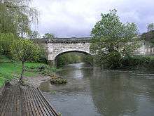 Avoncliff Aqueduct |
| Barton Swing Aqueduct | Bridgewater Canal | Sir Edward Leader Williams | 53.474813°N 2.350334°W | Crosses the Manchester Ship Canal. Swings to let large vessels pass below. | 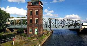 Barton Swing Aqueduct |
| Beam Aqueduct | Rolle Canal | James Green | 50.9672°N 4.1754°W | Formerly carried the Rolle Canal across the River Torridge | 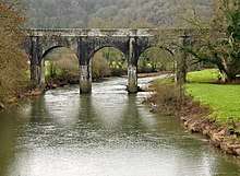 Beam Aqueduct |
| Bonnington Aqueduct | Union Canal | 55.9244°N 3.4144°W | Crosses the B7030 Cliftonhall Road | 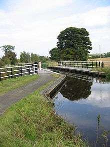 Bonnington Aqueduct near the M8 | |
| Bullbridge Aqueduct | Cromford Canal | 53.06404°N 1.46424°W | Demolished 1968. Originally crossed the Ambergate to Nottingham road. | 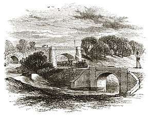 Old engraving of the demolished Bull Bridge Aqueduct | |
| Chirk Aqueduct | Llangollen Canal | 52.9287°N 3.0616°W | Crosses the Ceiriog Valley | 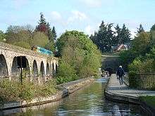 Chirk Aqueduct | |
| Clifton Aqueduct | Manchester, Bolton and Bury Canal | 53.527344°N 2.316814°W | Grade II listed building, crosses the River Irwell | 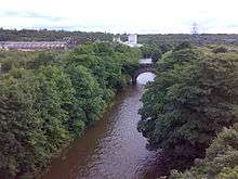 Clifton Aqueduct from Clifton Viaduct | |
| Cosgrove Aqueduct | Grand Union Canal | Benjamin Bevan | 52.068798°N 0.833641°W | Crosses the River Great Ouse. Built to replace an earlier aqueduct which collapsed. | 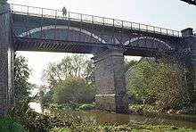 Cosgrove Aqueduct |
| Dowley Gap Aqueduct | Leeds and Liverpool Canal | James Brindley | 53.840295°N 1.815765°W | Crosses the River Aire. Also known as the Seven Arches Aqueduct. | 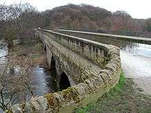 Dowley Gap Aqueduct |
| Dundas Aqueduct | Kennet and Avon Canal | John Rennie | 51°21′40″N 02°18′36″W | Crosses the River Avon (Bristol) and the Wessex Main Line railway. Designed in a classical style, this is now a Scheduled Monument | 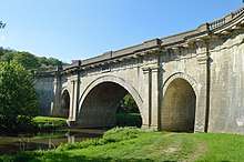 Dundas Aqueduct |
| Edstone Aqueduct | Stratford-upon-Avon Canal | 52.2464°N 1.7641°W | The longest aqueduct in England, crosses a minor road, the Birmingham and North Warwickshire railway, and also the trackbed of the former Alcester Railway. | 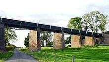 Edstone Aqueduct | |
| Engine Arm Aqueduct | Birmingham Canal Navigations | 52.4979°N 1.9665°W | Cast by Horseley Ironworks. Carries the Engine Arm over the BCN Main Line |  The Engine Arm Aqueduct | |
| Ewood Aqueduct | Leeds and Liverpool Canal | 53.7335°N 2.4926°W | Grade II listed building, crosses the River Darwen & B6447 |  Ewood Aqueduct | |
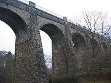
| Glen Loy Aqueduct | Caledonian Canal | 56.8903°N 5.0398°W | Carries the Caledonian Canal over the River Loy | .jpg) Glen Loy Viaduct | |
| Holliday Street Aqueduct | Worcester and Birmingham Canal | 52.4762°N 1.9079°W | A Grade II listed building adjacent to Gas Street Basin. | 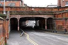 In the form of an extended tunnel which includes the original Bridge Street approach to old Worcester Wharf | |
| Kelvin Aqueduct | Forth and Clyde Canal | Robert Whitworth | 55.8923°N 4.3017°W | Carries Forth and Clyde Canal over the River Kelvin | 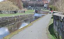 Kelvin Aqueduct |
| Lichfield Canal Aqueduct | Lichfield Canal | 52.655164°N 1.901584°W | A modern construction for a canal under restoration; not yet in water. Crosses the M6 Toll. | 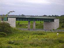 View of the open ended aqueduct over the M6 Toll | |
| Luggie Aqueduct | Forth and Clyde Canal | John Smeaton | 55.939655°N 4.151065°W | Category A listed building, crosses the Luggie Water (now culverted) | 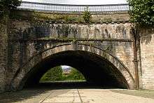 Luggie Aqueduct |
| Lune Aqueduct | Lancaster Canal | John Rennie | 54°4′5.94″N 2°47′21.07″W | Grade II listed building, crosses the River Lune | 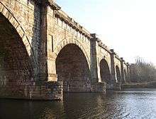 Lune Aqueduct |
| Marple Aqueduct | Peak Forest Canal | Benjamin Outram and Thomas Brown | 53.4073°N 2.0691°W | A Scheduled Monument, crosses the River Goyt. Grade II listed. |  |
| Murtry Aqueduct | Dorset and Somerset Canal | 51.247°N 2.342°W | Never used. Spans the Mells River near Frome, Somerset | .jpg) | |
| Nantwich Aqueduct | Shropshire Union Canal | Thomas Telford | 53.069231°N 2.535698°W | Cast-iron aqueduct dated around 1826; grade II* listed; crosses the A534 just outside Nantwich. | 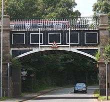 Nantwich Aqueduct |
| New Semington Aqueduct | Kennet and Avon Canal | 51.34709°N 2.14497°W | Modern aqueduct opened in 2004, crosses the A350 road. |  New Semington Aqueduct | |
| North Circular Road Aqueduct | Grand Union Canal (Paddington Branch) | 51°32'17"N 0°16'54"W | Original aqueduct opened 1933, replacement opened 1993 to span widened North Circular Road A406 | ||
| Pontcysyllte Aqueduct | Llangollen Canal | Thomas Telford | 52.970534°N 3.087834°W | A cast iron trough 1,007 feet long supported 126 feet above the river by 19 masonry piers. Crosses the River Dee. Unesco World Heritage site. |  Pontcysyllte Aqueduct, Wales |
| Prestolee Aqueduct | Manchester, Bolton and Bury Canal | 53.5525°N 2.3764°W | Grade II listed building, crosses the River Irwell. | 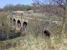 Prestolee Aqueduct | |
| Rea Aqueduct | Leominster Canal | 52.33°N 2.51°W | Crosses the River Rea | 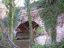 Rea Aqueduct | |
| River Cart Aqueduct (Blackhall Bridge) |
Former Glasgow, Paisley and Johnstone Canal | John Rennie and Thomas Telford | 55.839986°N 4.406396°E | Carried former Glasgow, Paisley and Johnstone Canal across White Cart Water. Now converted to railway viaduct. | 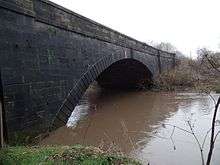 River Cart Aqueduct |
| Scott Russell Aqueduct | Union Canal | 55.9218°N 3.3070°W | Passes over the A720 Edinburgh Bypass | 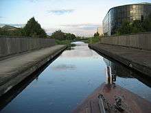 Scott Russell Aqueduct, Scotland | |
| Semington Aqueduct | Kennet and Avon Canal | 51.34709°N 2.14497°W | Crosses Semington Brook | 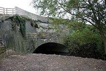 Semington Aqueduct | |
| Slateford Aqueduct | Union Canal | 55.9175°N 3.2499°W | Crosses Inglis Green Road and the Water of Leith | 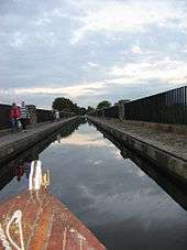 Slateford Aqueduct, Scotland | |
| Stockingfield Aqueduct | Forth and Clyde Canal | Robert Whitworth | 55.8927°N 4.2863°W | Crosses Lochburn Road Road in the Lambhill district of Glasgow |  Stockingfield Aqueduct, Scotland |
| Stanley Ferry Aqueduct | Aire and Calder Navigation | George Leather | 53.702417°N 1.462394°W | One of the earliest through arch bridges in the world, crosses the River Calder, West Yorkshire. | 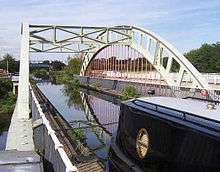 Stanley Ferry Aqueduct |
| Stewart Aqueduct | BCN Main Line | Thomas Telford | 52.5059°N 1.9974°W | The M5 motorway (1970) crosses the West Coast Main Line (1852) crosses the BCN Old Main Line Canal (1770) crosses the BCN New Main Line Canal (1828) | 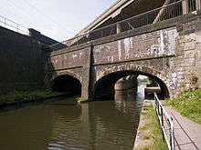 Stewart Aqueduct from the New Main Line |
| Store Street Aqueduct | Ashton Canal | Benjamin Outram | 53°28′46.39″N 2°13′38.45″W | Built on a skew of 45 degrees across the highway, and believed to be the first of its kind in Great Britain. Crosses Store Street, Manchester. | 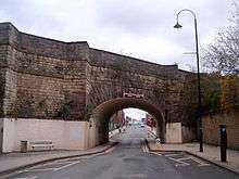 Store Street Aqueduct |
| Stretton Aqueduct | Shropshire Union Canal | Thomas Telford | 52.694267°N 2.189412°W | One of Telford's last aqueducts and grade II listed since 1985. Crosses the A5 road. |  Stretton Aqueduct carrying the Shropshire Union Canal over the A5. The inscription in the centre panel reads: "Birmingham and Liverpool Canal Thos. Telford F.R.S.I.& E. Engineer 1832" |
| Three Bridges, London | Grand Junction Canal | Isambard Kingdom Brunel | 51.5044182°N 0.3554333°W | Brunel's last major project, and a scheduled monument, a unique arrangement carrying rail, road, and canal routes across each other. | 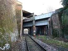 View of canal and road bridges crossing the railway line looking east |
| Wootton Wawen Aqueduct | Stratford-upon-Avon Canal | W Whitmore | 52.264039°N 1.769911°W | Crosses the A3400 road. | 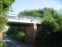 Wootton Wawen Aqueduct spans the A3400 |
| Yarningale Aqueduct | Stratford-upon-Avon Canal | 52.2952°N 1.7316°W | Crosses Kingswood Brook. | 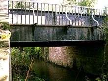 Yarningale aqueduct spans Kingswood Brook |
See also
References
This article is issued from Wikipedia. The text is licensed under Creative Commons - Attribution - Sharealike. Additional terms may apply for the media files.