List of bridges in Hamburg
This list of bridges in Hamburg has no claim to be complete, but rather just give an overview of their history and scope. For this article, the bridges are listed by Hamburg's three major rivers (Alster, Bille and Elbe) and the respectively crossed body of water (river, creek, canal, fleet, harbor basin or else). The Elbe is by far the largest of the three. Unlike Alster and Bille, the Elbe is also within the North Sea's tidal influence, and Elbe bridges differ substantially from the ones on Alster and Bille. All three rivers are fed by a number of smaller rivers and also feature a number of branches or sidearms.
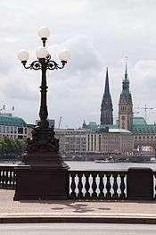


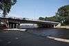
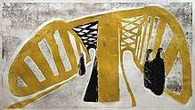
From left to right: (1) Lombardsbrücke with the urban ensemble of the Binnenalster, (2) Alte Harburger Elbbrücke, one of many riveted truss bridges dating from the Industrial Age, (3) Köhlbrandbrücke, part of today's modern transport infrastructure.
Hamburg has the most bridges of any city in Europe. Besides the Hanseatic city's mercantile and maritime history, the many rivers, canals and bridges constitute to Hamburg's association as the "Venice of the North". A 2004 report by the Department for Roads, Bridges and Waterways (LSBG) states a total number of 2,496 bridges in Hamburg,[1][2] many more than cities like Venice, Amsterdam or Saint Petersburg. Given the city's waterborne geography and the port's heavy duty requirements, bridges in Hamburg also cover a great variety of architectural styles and innovative structural systems.[3] Function-wise the total number of bridges break down to 1,172 road bridges, 987 railroad bridges (of which 407 Hochbahn bridges) and 470 footbridges (of which 290 within public parks and green spaces).[1][3] 383 bridges are under management of the Hamburg Port Authority.[3]
The most notable bridges in Hamburg include the historic inner-city bridges passing the Lower Alster (plus canals), the bridges across Speicherstadt canals, and the grand bridges spanning the Elbe's Norderelbe and Süderelbe anabranches, most commonly known as Elbbrücken.
Bridges in the Alster river system


For centuries, the only bridges in Hamburg were across the Lower Alster and its canals in the Altstadt (old town). Repeated redirecting of the Alster canals resulted in ever new bridges to go with them. Ultimately, most of the pre-17th century bridges were destroyed in the Great Fire of 1842; the oldest remaining bridges in Hamburg are Zollenbrücke (1633) and Ellerntorsbrücke (1668).
Most of today's bridges in the inner city date from the 1840s reconstruction, during which over two dozen, mainly Renaissance Revival stone arch bridges were erected under then building director Johann Hermann Maack (1809–1868). Maack's bridges tied into a general urban redevelopment of the inner city[3] which was similarly seen in a number of European cities of the mid 19th century, and still characterizes many of the Neustadt's canals.
Most of the bridges across the Upper Alster and adjoining canals were first built in conjunction with the area's extensive residential developments from the 1860s onwards. Some of them were gradually replaced during the 1920s, with Fritz Schumacher in particular establishing a brick-arch-prototype for many bridges.
Alster
Bridges across the Alster (Alsterbrücken) in Hamburg; some 31 km (19 mi) of the Alster's total of 56 km (35 mi) lie within Hamburg.
Upper Alster
A great number of the city's Alster bridges are located in the residential districts along the Upper Alster and its tributaries and accompanying side canals.
| Image | Name | Built | Length | Location | Notes | |||
|---|---|---|---|---|---|---|---|---|
| ↓ Alster (Hamburg state border) | ||||||||
 | Ratsmühlendammbrücke | 1991 | Fuhlsbüttel, Ohlsdorf | |||||
 | Hasenbergbrücke | 1913 | Ohlsdorf | |||||
 | Sengelmannbrücke | 1919 (2001) | 36 m (118 ft) | Alsterdorf | ||||
 | Hindenburgbrücke | 1920 | Alsterdorf | |||||
 | Dammbrücke | 1918 | Alsterdorf | |||||
 | Metzgerbrücke | Alsterdorf | ||||||
 | Deelbögebrücke | Alsterdorf | ||||||
| Bahnbrücke | 1941 | Alsterdorf | carries the Hamburg freight rail bypass | |||||
 | Meenkbrücke | Eppendorf, Winterhude | ||||||
 | Fährhausbrücke | Eppendorf, Winterhude | ||||||
| ↓ Eppendorfer Mühlenteich | ||||||||
 | Hudtwalckerbrücke | 1921 | 72 m (236 ft) | Eppendorf, Winterhude | carries Hudtwalckerstraße, part of Bundesstraße 5 | |||
 | U1 Hochbahn Viaduct | 1912 | Eppendorf, Winterhude | carries Hamburg U-Bahn line U 1 | ||||
 | U3 Hochbahn Viaduct | 1912 | Eppendorf, Winterhude | carries Hamburg U-Bahn line U 3 (Circle line) | ||||
 | Goernebrücke | 1909 | 72 m (236 ft) | Eppendorf, Winterhude | ||||
 | Streekbrücke 53°35′1″N 9°59′43″E | 1913[4] (1927) | 40 m (130 ft) | Harvestehude, Winterhude | ||||
 | Krugkoppelbrücke 53°34′48″N 9°59′58″E | 1890[4] (1928) | 72 m (236 ft) | Harvestehude, Winterhude | designed by Fritz Schumacher | |||
| ↓ Außenalster | ||||||||
- For bridges from the Außenalster downstream, see section for Lower Alster bridges.

.3.22022.ajb.jpg)
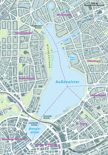
Rivers and canals joining from the left are: Osterbekkanal at Langer Zug, and Mundsburger Kanal at the Außenalster's greatest width.
The Alster is joined by the Tarpenbek at Eppendorfer Mühlenteich on its right side; a little further downstream, the Leinpfadkanal branches off the Alster's left side and creates a water link with a number of canals, including the Goldbekkanal, which in turn feeds into the Alster's system at Außenalster. Again on the right ride, the Isebekkanal joins the Alster's water shortly before reaching the Außenalster.
Bridges across Tarpenbek; the Tarpenbek empties into the Alster at Eppendorfer Mühlenteich.
|
Bridges across Leinpfadkanal; the Leinpfadkanal runs parallel to the Alster.
|
Bridges across Isebek and Isebekkanal
|
Bridges across Barmbeker Stichkanal, Goldbekkanal, Mühlenkampkanal and Rondelkanal
|
Lower Alster

Bridges across the Lower Alster (from the Außenalster downstream); this section lists most bridges in the inner city districts Altstadt and Neustadt.
| Image | Name | Built | Length | Location | Notes | |||
|---|---|---|---|---|---|---|---|---|
| ↓ Außenalster | ||||||||
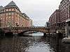
 | Kennedybrücke 53°33′28″N 9°59′53″E | 1953 | 126 m (413 ft) | Rotherbaum, St. Georg | designed by Bernhard Hermkes; originally named Neue Lombardsbrücke (until 1963) | |||
 | Lombardsbrücke 53°33′25″N 9°59′50″E | 1651 (1868)[4] | 69 m (226 ft) | Neustadt, Altstadt | designed by Johann Hermann Maack; part of the Wallring, also carries the Hamburg-Altona link line | |||
| ↓ Binnenalster | ||||||||
 | Reesendammbrücke 53°33′7″N 9°59′39″E | 1844[4] | 47 m (154 ft) | Neustadt, Altstadt | designed by Johann Hermann Maack, carries the Jungfernstieg | |||
| ↓ Kleine Alster | ||||||||
 | Schleusenbrücke | 1870 | Neustadt, Altstadt | |||||
| ↓ Alster continues as Alsterfleet | ||||||||
 | Adolphsbrücke | 1845 | 36 m (118 ft) | Neustadt, Altstadt | designed by Johann Hermann Maack, replaced the Scheelengangsbrücke | |||
 | Heiligengeistbrücke | 1885 | 51 m (167 ft) | Neustadt, Altstadt | ||||
 | Slamatjenbrücke | 1959 | Neustadt, Altstadt | |||||
| Binnenhafenbrücke | Neustadt, Altstadt | |||||||
.ajb.jpg) | Otto-Sill-Brücke | Neustadt, Altstadt | ||||||
| ↓ Norderelbe at Binnenhafen | ||||||||
- For bridges across Binnenhafen, see section for Oberhafen, Zollkanal and Binnenhafen bridges.
Bridges across Bleichenfleet and Herrengrabenfleet in Neustadt
|
Bridges across Mönkedammfleet and Nikolaifleet in Altstadt
| ||||||||||||||||||||||||||||||||||||||||||||||||||||||||||||||||||||||||||||||||||||||||
.ajb.jpg)
.ajb.jpg)


.ajb.jpg)

.ajb.jpg)
.ajb.jpg)


.S%C3%BCdseite.ajb.jpg)
.ajb.jpg)
.ajb.jpg)
- For bridges across Zollkanal, see section for Oberhafen, Zollkanal and Binnenhafen bridges.
Osterbek
Bridges across Osterbek and Osterbekkanal
.Blick_von_Westen.2.22314.ajb.jpg)
.1.21977.22329.23210.23211.24448.ajb.jpg)
- Bramfelder Brücke (1900)
- U3 Osterbekkanal Hochbahn Viaduct (1912)
- Hufnerstraßenbrücke
- Käthnerortbrücke
- Schleidenbrücke
- Großheidesteg
- Heinz-Gärtner-Brücke
- Mühlenkampbrücke (1900)
- Langenzugbrücke (1864, 1909)
- For bridges from the Außenalster downstream, see section for Lower Alster bridges.
Uhlenhorster Kanal
Bridges across Hofwegkanal and Uhlenhorster Kanal
- Grillparzerbrücke
- Fährbrücke
- Hofwegbrücke (1894)
- Herbert-Weichmann-Brücke (1893)
- Feenteichbrücke (1884)
- For bridges from the Außenalster downstream, see section for Lower Alster bridges.
Wandse
Bridges across Wandse, Eilbek, Eilbekkanal and Mundsburger Kanal
| Image | Name | Built | Length | Location | Notes | |
|---|---|---|---|---|---|---|
| ↓ Wandse (Hamburg state border) | ||||||
| Wandsbeker Königstraßenbrücke | Wandsbek | |||||
| ↓ Mühlenteich | ||||||
| Mühlenstraßenbrücke | Wandsbek | |||||
| Bahnbrücke | Eilbek, Barmbek-Süd | carries the Hamburg freight rail bypass | ||||
| ↓ Wandse continues as Eilbek | ||||||
| Eilbecker Brücke | Eilbek, Barmbek-Süd | |||||
| Friedrichsberger Brücke | Eilbek, Barmbek-Süd | |||||
| Maxstraßenbrücke | 1908 | Eilbek, Barmbek-Süd | ||||
| ↓ Wandse continues as Eilbekkanal | ||||||
 | Von-Essen-Straßenbrücke | Eilbek, Barmbek-Süd | ||||
| Wagnerstraßenbrücke | Eilbek, Barmbek-Süd | |||||
 | Richardstraßenbrücke | 1899[4] | Eilbek, Barmbek-Süd | |||
 | Wartenaubrücke | 1908[4] | Hohenfelde, Uhlenhorst | carries Wartenau, part of Bundesstraße 5 | ||
| ↓ Kuhmühlenteich | ||||||
 | Kuhmühlenteichbrücke | 1912 | 65 m (213 ft)[4] | Hohenfelde, Uhlenhorst | carries Hamburg U-Bahn line U 3 (Circle line) | |
| ↓ Wandse continues as Mundsburger Kanal | ||||||
 | Kuhmühlenbrücke | 1870[4] (1967) | Hohenfelde, Uhlenhorst | |||
 | Mundsburger Brücke | 1870[4] | 59.3 m (195 ft) | Hohenfelde, Uhlenhorst | designed by Christian Wilhelm Plath and William Lindley | |
 | Schwanenwikbrücke 53°33′56″N 10°1′1″E | 1878[4] | 55 m (180 ft) | Hohenfelde, Uhlenhorst | designed by Franz Andreas Meyer | |
| ↓ Außenalster | ||||||
- For bridges from the Außenalster downstream, see section for Lower Alster bridges.
Bridges in the Bille river system
Bille
Bridges across the Bille in Hamburg; 23 km (14 mi) of the Bille's total of 65 km (40 mi) lie within Hamburg.
| Image | Name | Built | Length | Location | Notes | |
|---|---|---|---|---|---|---|
| ↓ Bille (Hamburg state border) | ||||||
| Ernst-Mantius-Brücke | Bergedorf | |||||
| ↓ Schlossteich | ||||||
| Sehrrahnbrücke | Bergedorf | |||||
| ↓ Sehrrahn | ||||||
| Bergedorfer Brücke | Bergedorf | carries Bergedorfer Straße, part of Bundesstraße 5 | ||||
| Ladenbeker-Furtweg-Brücke | Bergedorf | |||||
.ajb.jpg) | Bojewiesenbrücke | Bergedorf | ||||
.ajb.jpg) | Rote Brücke | Billbrook | ||||
| Gelbe Brücke | Billstedt, Billbrook | |||||
| Blaue Brücke | Horn, Billbrook | |||||
| Braune Brücke | Hamm, Rothenburgsort | |||||
| Grüne Brücke | 1911[4] | Hammerbrook, Rothenburgsort | ||||
| Schwarze Brücke | 1909[4] | Hammerbrook, Rothenburgsort | carries Heidenkampsweg, part of Bundesstraße 75 | |||
| Zweite Amsinckbrücke | Hammerbrook, Rothenburgsort | carries Amsinckstraße, part of Bundesstraße 4 | ||||
| ↓ Norderelbe at Oberhafen | ||||||
- For bridges across Oberhafen, see section for Oberhafen, Zollkanal and Binnenhafen bridges.
Hammerbrook canals
Bridges across Hammerbrook and Rothenburgsort canals

|
|
Bridges in the Elbe river system

Up until the 19th century, the Unterelbe had no fixed crossing. Travel time between Hamburg and Harburg took over two hours, and included two ferry trips across the Norder- and Süderelbe and a weary trip across the dikes of Wilhelmsburg. During Napoleon's brief annexion of Hamburg, a 4 kilometers (2.5 miles) long pile bridge was built across the islands of Wilhelmsburg, however it also required cable ferries across the Elbe's two anabranches. In 1817 the poorly maintained structure was washed away.
By the 1840s, with industrialization rapidly growing and trade through the Port of Hamburg skyrocketing, the need for a fixed crossing became apparent. At the time, the German states were a loose confederation of sovereign states, with the Free and Hanseatic City of Hamburg only controlling the northern Elbe shore, while the town of Harburg and the southern Elbe shore were part of the Kingdom of Hanover. Both sides built their railway lines: Hamburg–Bergedorf railway in 1842 (extended to Berlin in 1846), and Celle–Harburg railway in 1847 (connected to Hanover since 1845) – but no link across the Elbe. One of the biggest obstacles was Hanover's rivalry to Hamburg and her attempts to promote overseas trade through the Port of Harburg.

Twenty years on, the missing link became a void in the European rail network. Progress was finally possible after Prussia's annexation of Hanover in 1866; within a few years the Cologne-Minden Railway Company (CME) completed the Venlo–Hamburg railway as North German section of a Paris–Hamburg railway line, and thereby linking Hamburg with the industrial centers of the Rhineland and the Low Countries. The first railway bridges across Norder- and Süderelbe were built between 1869 and 1872, nowadays part of the Elbbrücken. Also starting in 1866, the port's infrastructure was substantially re-organized, in order to cope with the increased quantity of processed goods and to meet requirements of then commonly employed steam-powered vessels. This included an expansion of the port onto the islands of Steinwerder, Veddel and Wilhelmsburg, and set-up of an extensive rail network for the newly established Hamburg port railway (Hafenbahn). In 1887, the Neue Elbbrücke with its three lenticular trusses (each 102 meters long) became a Hamburg landmark and the first road bridge to cross the Norderelbe, serving many of the port's businesses. By 1899, the Alte Harburger Elbbrücke provided a road link across the Süderelbe.
New bridges across the Elbe anabranches and the Elbe islands' canals were and are continued to be built to this day. Over the years, some of them have set new standards or records in engineering.[3] With the Elbe bridges being perceived as a symbol of the many changes associated with the Industrial Age, they were continuously subject to artistic and intellectual reception, among others by artists of the Hamburg Secession (Sezession) during the interwar period, or latest by the Internationale Bauausstellung during the 2000s. In 2015, the Speicherstadt was acknowledged as a World Heritage Site.
Elbe
Bridges across the Elbe (Elbbrücken) in Hamburg; some 40 km (25 mi) of the Elbe's total of 1,094 km (680 mi) lie within Hamburg. Up-stream, the next bridge (outside the Hamburg state borders) is located at Geesthacht; down-stream there are no more bridges.
Norderelbe
Bridges across the Norderelbe

Neue Freihafenbrücke and Köhlbrandbrücke are the last bridges on the respective riverarm, and also the Elbe's last bridges before reaching the North Sea. Only subsequent river crossings are the Old Elbe Tunnel in St. Pauli and the Bundesautobahn 7's New Elbe Tunnel west of Altona.
| Image | Name | Built | Length | Location | Notes | |
|---|---|---|---|---|---|---|
| ↓ Elbe (Hamburg state border) | ||||||
 | Moorfleeter Brücke 53°31′0″N 10°4′0″E | 1962 | 411 m (1,348 ft) | Moorfleet, Wilhelmsburg | designed by Hellmut Homberg, carries Bundesautobahn 1 | |
 | Neue Elbbrücke 53°32′0″N 10°2′0″E | 1887 (1959) | 304.7 m (1,000 ft) | Veddel, Rothenburgsort, Hammerbrook | designed by Hermann Lohse, carries Bundesstraße 4 and 75 | |
 | Eisenbahnbrücke 53°31′58″N 10°1′23″E | 1872 | Veddel, Rothenburgsort, Hammerbrook | designed by Heinrich Strack; carries the Hanover–Hamburg and Wanne-Eickel–Hamburg railway lines | ||
 | Neue Freihafenelbbrücke | 1917 | 340 m (1,120 ft) | Veddel, Rothenburgsort, Hammerbrook | carries the Hamburg port railway | |
| ↓ confluence with Süderelbe to become Niederelbe (Lower Elbe) | ||||||

Oberhafen, Zollkanal and BinnenhafenBridges across Oberhafen, Zollkanal and Binnenhafen between Hammerbrook, Altstadt and HafenCity
|
Speicherstadt and HafenCity canalsBridges across Speicherstadt and HafenCity canals within HafenCity (sorted alphabetically by name of waterbody)
|
Süderelbe
Bridges across the Süderelbe
| Image | Name | Built | Length | Location | Notes | |
|---|---|---|---|---|---|---|
| ↓ Elbe (Hamburg state border) | ||||||
 | Moorwerder Brücke 53°28′0″N 10°1′0″E | 970 m (3,180 ft) | Moorwerder, Wilhelmsburg | carries Bundesautobahn 1 | ||
 | Eisenbahnbrücke 53°28′25″N 9°59′44″E | 1872 (1979) | 340 m (1,120 ft) | Harburg, Wilhelmsburg | carries the Hanover–Hamburg and Wanne-Eickel–Hamburg railway lines | |
 | Europabrücke 53°31′58″N 10°1′23″E | 1983 | 471 m (1,545 ft) | Harburg, Wilhelmsburg | carries Bundesautobahn 253 | |
| Brücke des 17. Juni | 1937 (1949) | 472 m (1,549 ft) | Harburg, Wilhelmsburg | originally named Wilhelmsburger Brücke, renamed after the 1953 uprising in East Germany | ||
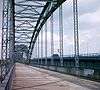 | Alte Harburger Elbbrücke 53°28′0″N 10°0′0″E | 1899 | 474 m (1,555 ft) | Harburg, Wilhelmsburg | designed by Hubert Stier | |
 | Kattwykbrücke 53°29′40″N 9°57′6″E | 1973 | 290 m (950 ft) | Moorburg, Wilhelmsburg | the world's tallest lift bridge, with a liftable height of 46 m (151 ft) | |
| ↓ Süderelbe continues as Köhlbrand | ||||||
 | Köhlbrandbrücke 53°31′18″N 9°56′18″E | 1974 | 3,940 m (12,930 ft) | Waltershof, Steinwerder | designed by Paul Boué, Egon Jux and Hans Wittfoht; was the world's longest cable-stayed bridge from 1974 to 1991 | |
| ↓ confluence with Norderelbe to become Niederelbe (Lower Elbe) | ||||||
Este
Bridges across the Este in Hamburg; only 2 km (1.2 mi) of the Este's total of 62 km (39 mi) lie within the state borders of Hamburg.
- Cranzer Rollbrücke
- Estesperrwerkbrücke
Harburg canals
Bridges across harbor basins and canals in Harburg; the port of Harburg is indirectly fed through the Seeve.
|
|
Wilhelmsburg canals
Bridges across Elbe anabranches and canals on the island of Wilhelmsburg (including the islands of Steinwerder, Kleiner Grasbrook and Veddel)


|
|
Bridges elsewhere
Please note, this section only lists bridges and viaducts in Hamburg, not listed above (i.e. only bridges and viaducts not crossing a body of water).
Railway bridges and viaducts
|
|
Road bridges and viaducts
- Hochstraße Elbmarsch (1973, 4,258 m)
- Kersten-Miles-Brücke (1897, 47 m)
- Simon-von-Utrecht-Brücke
Foot bridges
- Cremonbrücke (1982)
- Johan-van-Valckenburgh-Brücke
See also
- St. Pauli Landing Bridges (Landungsbrücken)
- List of rivers of Hamburg
- List of bridges
Literature
- Sven Bardua: Brückenmetropole Hamburg, Dölling und Galitz, Hamburg, 2009
- Horst Beckershaus: Die Hamburger Brücken: ihre Namen, woher sie kommen und was sie bedeuten, Convent, Hamburg, 2007, ISBN 3866330073
- Ralf Lange: Architekturführer Hamburg/Architectural Guide to Hamburg, Edition Axel Menges, Fellbach, 1995, ISBN 3930698587
References
- Landesbetrieb Straßen, Brücken und Gewässer (LSBG) Hamburg, 2004
- private bridges excluded (e.g. factory premises or Hagenbeck's Tierpark)
- Friedhelm Grundmann, Michael Zapf: Hamburg - Stadt der Brücken, Schubert; Leipzig, 2003, ISBN 3929229897
- Hamburg und seine Bauten 1914, unter Berücksichtigung der Nachbarstädte Altona und Wandsbek (in German). Bd. 2. Hamburg: Architekten- und Ingenieurverein zu Hamburg. 1914. pp. 165 ff.
External links
![]()
- Landesbetrieb Straßen, Brücken und Gewässer (LSBG) – Department for Roads, Bridges and Waterways (in German)
- Bridges in Hamburg at brueckenweb.de (in German and English)
Freie und Hansestadt Hamburg | |
| Government and Symbols | |
| History and Culture |
|
| Economy and Transport | |