List of baseball parks in Philadelphia
This is a list of venues used for professional baseball in Philadelphia. The information is a synthesis of the information contained in the references listed.
Citizens Bank Park
Veterans Stadium

Shibe Park a.k.a. Connie Mack Stadium
Columbia Park

Baker Bowl
- "Athletic(s) grounds" or "the grounds at 15th and Columbia"
- Occupant: Athletic 1860s–1870 (amateur/professional)
- Site of several celebrated matches between the Athletics and the Atlantics of Brooklyn, on Oct 31, 1865; and on Oct 1 and 22, 1866
- Location: Columbia Avenue (now Cecil B. Moore Avenue); 15th Street; other boundaries unknown
- Currently: part of the Temple University campus
- Jefferson Street Grounds a.k.a. Jefferson Park a.k.a. Athletics Park
- Occupants:
- Amateur clubs, including Olympic, beginning 1864
- Athletic – NA (1871–1875), NL (1876)
- Philadelphia White Stockings – NA (1873–1875)
- Athletic – AA (1883–1890?)
- Location: Jefferson Street (north); 25th Street (east); Master Street (south); 27th Street (west)
- 1860s-1870s orientation: 25th (first base); Master (third base); Jefferson (right field)
- 1880s-1890s orientation: 27th (first base); Jefferson (third base); 26th (left field)
- Currently: Residential / commercial / elementary School / Athletic Recreation Center
- Recreation Park / Centennial Park
- Occupants:
- Philadelphia Centennials – NA (1875)
- Philadelphia Phillies – NL (1883–1886)
- Location: Columbia Avenue (now Cecil B. Moore Avenue) (south); 25th Street (west); Montgomery Street (north); Ridge Avenue a.k.a. Ridge Pike (northeast); 24th or 23rd Street (east) – a few blocks east of the future Columbia Park site
- Currently: Residential
- Oakdale Park
- Occupants:
- Amateur clubs beginning about 1866
- Athletic – AA (1882)
- Location: West Kensington – Huntingdon Street (north); 11th Street (east); Cumberland Street (south); 12th Street (west) – a couple of blocks east of the future Baker Bowl site
- Currently: Residential / commercial
- Keystone Park
- Occupant: Keystone – UA (1884)
- Location: Broad Street; Wharton Street; 11th Street; Moore[?] Street
- Currently: Residential / commercial
- Baker Bowl (formally National League Park, originally Philadelphia Base Ball Park)
- Occupant: Philadelphia Phillies – NL (1887 – mid-1938)
- Location: Lehigh Avenue (north, left field); Broad Street (east, right field); Huntingdon Street (south, first base); 15th Street (west, third base)
- Currently: Commercial
- University Grounds
- Occupant: Philadelphia Phillies – NL (1894 for 6 games)
- Location: "37th and Spruce" – Spruce Street (north), 38th Street (east), Pine Street (south), Woodland Avenue and 37th Street T-intersection (northwest) – normally the home of University of Pennsylvania teams, prior to the opening of Franklin Field a few blocks east
- Currently: campus buildings and park
- Forepaugh Park
- Occupant: Athletic – PL (1890), AA (1891)
- Location: Broad Street; Dauphin Street – a few blocks south of the Baker Bowl and Oakdale Park sites
- Currently: Residential / commercial
- Columbia Park or Columbia Avenue Grounds
- Occupant: Philadelphia Athletics – AL (1901–1908)
- Location: Columbia Avenue (now Cecil B. Moore Avenue) (north, left field); North 29th Street (east, right field); Oxford Street (south, first base); North 30th Street (west, third base); Glenwood Avenue (northwest, left field corner), beyond Columbia-30th intersection
- Currently: Residential
- Shibe Park / Connie Mack Stadium
- Occupants:
- Philadelphia Athletics – AL (1909–1954)
- Philadelphia Phillies – NL (mid-1938 – 1970)
- Location: Lehigh Avenue (south, first base); 21st Street (west, third base); Somerset Street (north, left field); 20th Street (east, right field) – a few blocks west of Baker Bowl
- Currently: Deliverance Evangelistic Church
- Hilldale Park
- Occupant: Hilldale – Negro Leagues (ca. 1910–1932)
- Location: Darby, Pennsylvania – Chester Avenue; Cedar Avenue
- Currently: Residential / commercial / athletic fields
- 44th and Parkside Ballpark
- Occupant: Philadelphia Stars (ca. 1935–1950)
- Location: Belmont Avenue and Parkside Avenue
- Currently: Discovery Charter School and Philadelphia Stars Negro League Memorial Park
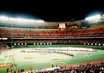
- Veterans Stadium
- Occupant: Philadelphia Phillies – NL (1971–2003)
- Location: 3501 South Broad Street – Broad Street (west, third base); South 10th Street (north, left field); Pattison Avenue (south, first base);
- Currently: Parking lot just west of Citizens Bank Park
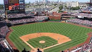
- Citizens Bank Park
- Occupant: Philadelphia Phillies – NL (2004–present)
- Location: 1 Citizens Bank Way – Pattison Avenue (south, home base); South 11th Street (west, third base / left field); South 10th Street (north, center field); South Darian Street (east, first base / right field)
See also
Sources
- Peter Filichia, Professional Baseball Franchises, Facts on File, 1993.
- Phil Lowry, Green Cathedrals, several editions.
- Michael Benson, Ballparks of North America, McFarland, 1989.
- Rich Westcott, Philadelphia's Old Ballparks, Temple University Press, 1996.
- Baseball Memories, by Marc Okkonen, Sterling Publishing, 1992.
This article is issued from Wikipedia. The text is licensed under Creative Commons - Attribution - Sharealike. Additional terms may apply for the media files.