List of Indiana state historical markers in Floyd County
This is a list of the Indiana state historical markers in Floyd County.
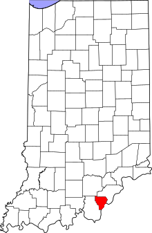
Location of Floyd County in Indiana
This is intended to be a complete list of the official state historical markers placed in Floyd County, Indiana, United States by the Indiana Historical Bureau. The locations of the historical markers and their latitude and longitude coordinates are included below when available, along with their names, years of placement, and topics as recorded by the Historical Bureau. There are 18 historical markers located in Floyd County.[1]
Historical markers
| Marker title | Image | Year placed | Location | Topics |
|---|---|---|---|---|
| Site of Camp Whitcomb[2] | 1966 | Southeastern corner of the junction of Beharrell Avenue and E. Spring Street in New Albany 38°17′57″N 85°47′40″W |
Military | |
| New Albany[3] | 1991 | W. Spring Street at the southbound offramp from Interstate 64 in New Albany 38°17′0″N 85°49′49″W |
Historic District, Neighborhoods, and Towns, Early Settlement and Exploration | |
| Michael C. Kerr Home[4] | 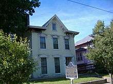 |
1992 | 1109 E. Main Street in New Albany 38°17′14.4″N 85°48′41″W |
Politics, Buildings and Architecture |
| New Albany[5] | 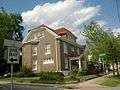 |
1992 | Junction of E. Spring Street and Woodrow Avenue in New Albany 38°17′55″N 85°47′44.7″W |
Historic District, Neighborhoods, and Towns, Early Settlement and Exploration |
| Clark's Grant[6] | 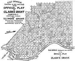 |
1992 | Indiana University Southeast, 4201 Grant Line Road/State Road 111, New Albany just north of Interstate 265 38°20′45″N 85°49′0″W |
Early Settlement and Exploration, Military |
| State Bank of Indiana[7] | 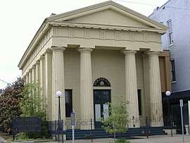 |
1996 | 203 E. Main Street in New Albany 38°17′4″N 85°49′15″W |
Buildings and Architecture, Government Institutions, Business, Industry, and Labor |
| Culbertson Mansion[8] | 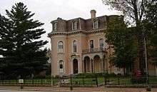 |
1996 | 914 E. Main Street in New Albany 38°17′11″N 85°48′47″W |
Buildings and Architecture, Business, Industry, and Labor |
| Scribner High School[9] | 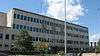 |
1998 | Southwestern corner of the junction of 1st and Spring Streets at the City-County Building in New Albany 38°17′6″N 85°49′31″W |
Education, African American |
| Buffalo Trace Route[10] | 1999 | 2212 State Street in New Albany 38°18′20.6″N 85°50′24.6″W |
Nature and Natural Disasters, Transportation | |
| Culbertson Widows' Home[11] | 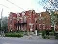 |
2003 | 704 E. Main Street in New Albany 38°17′9″N 85°48′54″W |
Women, Buildings and Architecture |
| A Gateway to Freedom[12] | 2004 | Southeastern corner of the junction of Main and Third Streets in New Albany 38°17′4″N 85°49′11″W |
Underground Railroad, African American | |
| New Albany Downtown Historic District[13] | 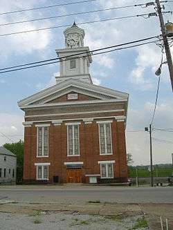 |
2004 | Northeastern corner of the junction of Pearl and Market Streets in New Albany 38°17′6″N 85°49′21″W |
Historic District, Neighborhoods, and Towns, Buildings and Architecture |
| Division Street School[14] | 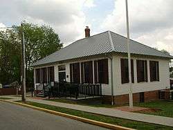 |
2005 | 1803 Conservative Street in New Albany 38°17′35″N 85°48′18″W |
African American, Education, Buildings and Architecture |
| Fairview Cemetery[15] | 2005 | Junction of Culbertson Avenue and E. Sixth Street in New Albany 38°17′27″N 85°49′11″W |
Cemetery, Politics | |
| New Albany's Carnegie Library[16] |  |
2005 | 201 E. Spring Street in New Albany 38°17′12″N 85°49′19″W |
Carnegie Library, Buildings and Architecture |
| New Albany Tornado, 1917[17] | 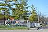 |
2007 | New Albany Children's Academy at 1111 Pearl Street in New Albany 38°17′40″N 85°49′37″W |
Nature and Natural Disasters |
| New Albany and Salem Railroad (The Monon)[18] | 2007 | Junction of Bank Street and Culbertson Avenue in New Albany 38°17′22.6″N 85°49′25″W |
Transportation, Underground Railroad | |
| Cardinal Joseph E. Ritter[19] | 2007 | Southwestern corner of the junction of E. 13th and E. Oak Streets in New Albany 38°17′32″N 85°48′46″W |
Religion, Education |
See also
References
- "Indiana Historical Markers by County". State of Indiana. Retrieved 2012-03-15.
- Site of Camp Whitcomb, Indiana Historical Bureau, n.d. Accessed 2012-03-14.
- New Albany, Indiana Historical Bureau, n.d. Accessed 2012-03-14.
- Michael C. Kerr Home, Indiana Historical Bureau, n.d. Accessed 2012-03-14.
- New Albany, Indiana Historical Bureau, n.d. Accessed 2012-03-14.
- Clark's Grant, Indiana Historical Bureau, n.d. Accessed 2012-03-14.
- State Bank of Indiana, Indiana Historical Bureau, n.d. Accessed 2012-03-14.
- Culbertson Mansion, Indiana Historical Bureau, n.d. Accessed 2012-03-14.
- Scribner High School, Indiana Historical Bureau, n.d. Accessed 2012-03-14.
- Buffalo Trace Route, Indiana Historical Bureau, n.d. Accessed 2012-03-14.
- Culbertson Widows' Home, Indiana Historical Bureau, n.d. Accessed 2012-03-14.
- A Gateway to Freedom, Indiana Historical Bureau, n.d. Accessed 2012-03-14.
- New Albany Downtown Historic District, Indiana Historical Bureau, n.d. Accessed 2012-03-14.
- Division Street School, Indiana Historical Bureau, n.d. Accessed 2012-03-14.
- Fairview Cemetery, Indiana Historical Bureau, n.d. Accessed 2012-03-14.
- New Albany's Carnegie Library, Indiana Historical Bureau, n.d. Accessed 2012-03-14.
- New Albany Tornado, 1917, Indiana Historical Bureau, n.d. Accessed 2012-03-14.
- New Albany and Salem Railroad (The Monon), Indiana Historical Bureau, n.d. Accessed 2012-03-14.
- Cardinal Joseph E. Ritter, Indiana Historical Bureau, n.d. Accessed 2012-03-14.
External links
Municipalities and communities of Floyd County, Indiana, United States | ||
|---|---|---|
| City | Map of Indiana highlighting Floyd County | |
| Towns | ||
| Townships | ||
| CDP | ||
| Other unincorporated communities | ||
This article is issued from Wikipedia. The text is licensed under Creative Commons - Attribution - Sharealike. Additional terms may apply for the media files.