Indiana State Road 111
State Road 111 (SR 111) in the U.S. State of Indiana is a rural two lane highway which passes between New Boston and New Albany in the far southern portion of the state. It has existed since 1935. Some of the highway was decommissioned in October 2012 and more was decommissioned in January 2013.
| ||||
|---|---|---|---|---|
 | ||||
| Route information | ||||
| Maintained by INDOT | ||||
| Length | 24.778 mi[1] (39.876 km) | |||
| Existed | 1935–present | |||
| Major junctions | ||||
| South end | Dead end at the Ohio River near New Boston | |||
| North end | Main Street in New Albany | |||
| Location | ||||
| Counties | Harrison, Floyd, Clark | |||
| Highway system | ||||
| ||||

Route description
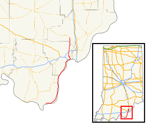
The southern terminus of State Road 111 is at a dead end on the shores of the Ohio River, near the small community of New Boston. From here, it runs to the north and east, closely following the course of the river for about 13 miles (21 km), at which point it intersects with the east–west State Road 211. It continues to follow the river toward Bridgeport. It continues north, entering downtown New Albany. From there, it turns to meet at its current northern terminus at the intersection between Main Street and State Street.[2]
History
Before 1935, SR 111 was known as SR 133. When U.S. Route 33 (US 33) commissioned in Indiana, SR 33 was decommissioned. SR 133 followed the same route as SR 111.[3][4] In October 2012, the portion of SR 111 in Clark County was turned over to the county, with the Floyd County portion turned over to the county in January 2013.[5][6]
Major intersections
| County | Location | mi[1] | km | Destinations | Notes |
|---|---|---|---|---|---|
| Harrison | Taylor Township | 0.000 | 0.000 | Dead end at the Ohio River | Southern terminus of SR 111 |
| Posey Township | 12.559 | 20.212 | Eastern terminus of SR 211 | ||
| Floyd | New Albany | 24.778 | 39.876 | Main Street State Street | Northern terminus of SR 111 |
| 1.000 mi = 1.609 km; 1.000 km = 0.621 mi | |||||
See also
References
- Indiana Department of Transportation (July 2016). Reference Post Book (PDF). Indianapolis: Indiana Department of Transportation. SR 111. Retrieved November 3, 2018.
- Google (November 3, 2018). "overview map of SR 111" (Map). Google Maps. Google. Retrieved November 3, 2018.
- Indiana Highway Ends: State Road 111 Archived 2012-03-24 at the Wayback Machine
- Indiana Highway Ends: State Road 133 Archived 2012-10-21 at the Wayback Machine
- Chris McGill. "Clark County Takes Over Former State Roads". Archived from the original on January 24, 2013. Retrieved January 24, 2012.
- "Floyd County Takes Over Two State Roads". Louisville, KY: WHAS. January 28, 2013. Archived from the original on September 25, 2008. Retrieved January 28, 2013.