Lions Peak
Lions Peak is a prominent hill in the eastern foothills of the Santa Cruz Mountains in southwest Santa Clara County, California. The landmark lies west of San Martin, and is adjacent to the resort village of CordeValle.[3] The headwaters of Lions Creek originate on the eastern flank of the hill, and flow southward before merging with Llagas Creek in Gilroy. The hill and surrounding area is located on approximately 1,400 acres (570 ha) of privately owned lands, and is viewable along U.S. Route 101 and California State Route 152 in South Santa Clara Valley.
| Lions Peak | |
|---|---|
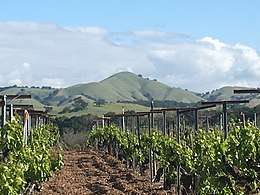 View of Lions Peak along Hecker Pass Highway | |
| Highest point | |
| Elevation | 1,117 ft (340 m) NGVD 29[1] |
| Prominence | 257 ft (78 m) NGVD 29[1] |
| Coordinates | 37°03′24″N 121°37′56″W [2] |
| Geography | |
 Lions Peak Location in California  Lions Peak Lions Peak (the United States) | |
| Location | Santa Clara County, California, U.S. |
| Parent range | Santa Cruz Mountains |
| Topo map | USGS Mount Madonna |
History
The land surrounding the peak, once part of the historic Rancho San Francisco de las Llagas, was purchased by Messrs Lion and Buckley in the late 19th century.[4]
In the summer of 2008, dry lightning ignited fires northwest of the hill, burning nearly 800 acres (320 ha) nearby.[5][6]
References
- "Lions Peak". ListsOfJohn.com. Retrieved 2014-03-10.
- "Lions Peak". Geographic Names Information System. United States Geological Survey. Retrieved 2014-03-10.
- Rosewood Resorts. "CordeValle". Retrieved 2017-08-13.
- Library of Congress. "1889 Map of the County of Santa Clara, California". San Jose, CA : Herrmann Bros., 1890.
- CalFire. "Hummingbird Fire, June 2008". Retrieved 2017-08-13.
- Morgan Hill Weather. "Video of Hummingbird Fire". Retrieved 2017-08-13.