Lika (river)
The Lika is a river in Croatia which gives its name to the Lika region. It is 77 kilometres (48 mi) long and it has a basin with an area of 1,014 square kilometres (392 sq mi). Its average discharge at the measurement station in Bilaj (covering 225 km2 of the basin) is 7.33 m3/s, and it can go completely dry.[1]
| Lika | |
|---|---|
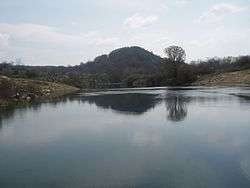 Lika River, near Kosinj | |
| Location | |
| Country | Croatia |
| Physical characteristics | |
| Source | |
| ⁃ location | Velebit Mountains |
| ⁃ elevation | 600 m (2,000 ft) |
| Mouth | |
⁃ location | ponor |
⁃ coordinates | 44°46′N 15°10′E |
⁃ elevation | 480 m (1,570 ft) |
| Length | 77 km (48 mi) |
| Basin size | 1,014 km2 (392 sq mi) |
| Discharge | |
| ⁃ average | 7.33 m3/s (259 cu ft/s) |
It is known as a sinking river because at the end of its course, it flows into a series of ponors or swallow-holes and disappears from the surface. The Lika River rises near the village of Kukljić at the foot of the Velebit Mountains, flows in a northwesterly direction past the town of Gospić, enters and leaves Lake Krušćica, and continues to the northwest until it sinks into the karst topography at ponors near Lipovo Polje.
References
| Wikimedia Commons has media related to Lika (river). |
- "Karakteristike značajnijih vodotoka". Vodnogospodarska osnova Hrvatske - Strategija upravljanja vodama (in Croatian). Croatian Parliament. Archived from the original on 2013-10-29. Retrieved 2011-12-18.
Hydrography of Croatia | ||
|---|---|---|
| Rivers |  | |
| Lakes | ||
| Valleys, estuaries, canyons, wetlands | ||
| Waterfalls | ||
| Canals |
| |
This article is issued from Wikipedia. The text is licensed under Creative Commons - Attribution - Sharealike. Additional terms may apply for the media files.