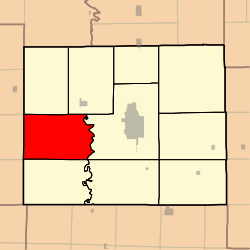
Liberty Township, Adair County, Missouri
Liberty Township is one of ten townships in Adair County, Missouri, United States. As of the 2010 census, its population was 324.[3] Liberty Township was probably named from the patriotic concept of liberty.[4]
Liberty Township, Missouri | |
|---|---|
 | |
| Coordinates: 40°09′50″N 092°46′13″W | |
| Country | United States |
| State | Missouri |
| County | Adair |
| Area | |
| • Total | 52.95 sq mi (137.15 km2) |
| • Land | 52.95 sq mi (137.15 km2) |
| • Water | 0.0 sq mi (0.0 km2) 0.0% |
| Elevation | 955 ft (291 m) |
| Population (2010) | |
| • Total | 324 |
| • Density | 6/sq mi (2.4/km2) |
| FIPS code | 29-41924[2] |
| GNIS feature ID | 0766212 |
Geography
Liberty Township covers an area of 52.94 square miles (137.1 km2). Its eastern boundary is formed by the Chariton River, and its western edge is that of the county. The township contains no incorporated settlements, though there are named places such as Midland (once known as Tipperary") and Youngstown, both of which served the coal mines once worked in the area. It contains seven cemeteries: Baden Springs, Lutz, Mount Moriah, Parcell Salisbury, Pinkerton, Pratt and Ringo Point.
References
- "US Board on Geographic Names". United States Geological Survey. 2007-10-25. Retrieved 2008-01-31.
- "U.S. Census website". United States Census Bureau. Retrieved 2008-01-31.
- "Geographic Identifiers: 2010 Demographic Profile Data (G001): Liberty township, Adair County, Missouri". U.S. Census Bureau, American Factfinder. Archived from the original on February 12, 2020. Retrieved June 20, 2013.
- Violette, E. M. (1911). History of Adair County. The Denslow History Company. pp. 39.
External links
Municipalities and communities of Adair County, Missouri, United States | ||
|---|---|---|
| Cities | 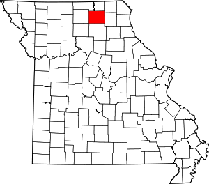 Map of Missouri highlighting Adair County | |
| Villages | ||
| Townships | ||
| Unincorporated communities | ||
| Ghost towns | ||
| Footnotes | ‡This populated place also has portions in an adjacent county or counties | |
This article is issued from Wikipedia. The text is licensed under Creative Commons - Attribution - Sharealike. Additional terms may apply for the media files.