Lewis Chapel, Tennessee
Lewis Chapel is an unincorporated community in Sequatchie County, Tennessee, United States.[1] It is located in the eastern part of the county atop the Cumberland Plateau. Tennessee State Route 111 connects the community to Dunlap in the Sequatchie Valley to the west and Soddy-Daisy and the outskirts of Chattanooga in the Tennessee Valley to the east.
Lewis Chapel, Tennessee | |
|---|---|
Unincorporated community | |
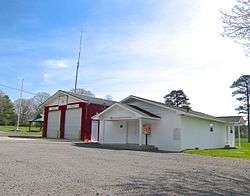 Lewis Chapel Volunteer Fire Department (left) and Lewis Chapel Community Center | |
 Lewis Chapel, Tennessee  Lewis Chapel, Tennessee | |
| Coordinates: 35°20′27″N 85°18′27″W | |
| Country | United States |
| State | Tennessee |
| County | Sequatchie |
| Elevation | 1,818 ft (554 m) |
| Time zone | UTC-6 (Central (CST)) |
| • Summer (DST) | UTC-5 (CDT) |
| ZIP codes | 37327, 37338 |
| Area code(s) | 423 |
| GNIS feature ID | 1291078[1] |
Lewis Chapel was probably named for the Reverend Edgar R. Lewis, an early minister in the area.[2]
References
- U.S. Geological Survey Geographic Names Information System: Lewis Chapel, Tennessee
- Larry Miller, Tennessee Place Names (Indiana University Press, 2001), p. 122.
Municipalities and communities of Sequatchie County, Tennessee, United States | ||
|---|---|---|
| City | Sequatchie County map | |
| CDP | ||
| Unincorporated community | ||
This article is issued from Wikipedia. The text is licensed under Creative Commons - Attribution - Sharealike. Additional terms may apply for the media files.