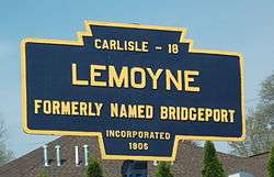
Lemoyne, Pennsylvania
Lemoyne is a borough in Cumberland County, Pennsylvania, United States. Lemoyne was incorporated as a borough on May 23, 1905. As of the 2010 census, the borough population was 4,553.[3] It was formerly named "Bridgeport". Lemoyne lies across the Susquehanna River from Harrisburg, Pennsylvania's capital. It is part of the Harrisburg–Carlisle Metropolitan Statistical Area.
Lemoyne, Pennsylvania Bridgeport | |
|---|---|
Borough | |
| Motto(s): "The little town that has it all!" | |
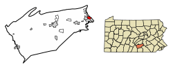 Location of Lemoyne in Cumberland County, Pennsylvania. | |
 Lemoyne Location in Pennsylvania and the United States  Lemoyne Lemoyne (the United States) | |
| Coordinates: 40°14′36″N 76°53′48″W | |
| Country | United States |
| State | Pennsylvania |
| County | Cumberland |
| Incorporated | 1905 |
| Government | |
| • Type | Borough Council |
| • Mayor | Gale Gallo |
| Area | |
| • Total | 1.61 sq mi (4.18 km2) |
| • Land | 1.61 sq mi (4.18 km2) |
| • Water | 0.00 sq mi (0.00 km2) |
| Elevation | 384 ft (117 m) |
| Population (2010) | |
| • Total | 4,553 |
| • Estimate (2018)[2] | 4,647 |
| • Density | 2,885.24/sq mi (1,113.92/km2) |
| Time zone | UTC-5 (Eastern (EST)) |
| • Summer (DST) | UTC-4 (EDT) |
| ZIP code | 17043 |
| Area code(s) | 717 |
| FIPS code | 42-42648 |
| Website | lemoynepa |
Lemoyne is served by Interstate 83 and U.S. Routes 11/15. Lemoyne is served by the West Shore School District.
Geography
Lemoyne is located on the eastern edge of Cumberland County at 40°14′36″N 76°53′48″W (40.243389, -76.896532),[4] on the west bank of the Susquehanna River, directly across from Harrisburg. It is bordered to the north by Wormleysburg, to the west by Camp Hill, and to the south by the borough of New Cumberland and Lower Allen Township.
According to the United States Census Bureau, the borough has a total area of 1.61 square miles (4.17 km2), all of it land.[3]
Demographics
| Historical population | |||
|---|---|---|---|
| Census | Pop. | %± | |
| 1910 | 1,393 | — | |
| 1920 | 1,939 | 39.2% | |
| 1930 | 4,171 | 115.1% | |
| 1940 | 4,358 | 4.5% | |
| 1950 | 4,605 | 5.7% | |
| 1960 | 4,662 | 1.2% | |
| 1970 | 4,625 | −0.8% | |
| 1980 | 4,178 | −9.7% | |
| 1990 | 3,959 | −5.2% | |
| 2000 | 3,995 | 0.9% | |
| 2010 | 4,553 | 14.0% | |
| Est. 2019 | 4,747 | [2] | 4.3% |
| Sources:[5][6][7] | |||
As of the census[6] of 2000, there were 3,995 people, 1,926 households, and 999 families residing in the borough. The population density was 2,565.8 people per square mile (988.8/km²). There were 2,027 housing units at an average density of 1,301.9 per square mile (501.7/km²). The racial makeup of the borough was 96.52% White, 0.58% African American, 0.08% Native American, 1.30% Asian, 0.55% from other races, and 0.98% from two or more races. 1.08% of the population were Hispanic or Latino of any race.
There were 1,926 households, out of which 23.2% had children under the age of 18 living with them, 39.7% were married couples living together, 9.4% had a female householder with no husband present, and 48.1% were non-families. 40.7% of all households were made up of individuals, and 11.1% had someone living alone who was 65 years of age or older. The average household size was 2.07 and the average family size was 2.84.
In the borough the population was spread out, with 20.6% under the age of 18, 8.1% from 18 to 24, 33.5% from 25 to 44, 23.1% from 45 to 64, and 14.6% who were 65 years of age or older. The median age was 37 years. For every 100 females, there were 90.1 males. For every 100 females age 18 and over, there were 88.3 males.
The median income for a household in the borough was $39,803, and the median income for a family was $47,438. Males had a median income of $32,284 versus $26,719 for females. The per capita income for the borough was $28,705. 5.7% of the population and 4.4% of families were below the poverty line. Out of the total population, 4.0% of those under the age of 18 and 7.9% of those 65 and older were living below the poverty line.
Notable people
- Bob Adams, baseball pitcher
- Edson Hendricks, computer scientist
- Stan Jones, football player
- Paul Minner, baseball pitcher
- Bob Moorhead, baseball pitcher
- Andy Musser, sports announcer
- Dean T. Stevenson, Episcopal bishop
- Helen Waddell, baseball player
- Erik V. Fasick, Writer
References
- "2017 U.S. Gazetteer Files". United States Census Bureau. Retrieved Mar 24, 2019.
- "Population and Housing Unit Estimates". Retrieved October 1, 2019.
- "Geographic Identifiers: 2010 Census Summary File 1 (G001): Lemoyne borough, Pennsylvania". U.S. Census Bureau, American Factfinder. Archived from the original on February 13, 2020. Retrieved June 18, 2015.
- "US Gazetteer files: 2010, 2000, and 1990". United States Census Bureau. 2011-02-12. Retrieved 2011-04-23.
- "Census of Population and Housing". U.S. Census Bureau. Retrieved 11 December 2013.
- "U.S. Census website". United States Census Bureau. Retrieved 2008-01-31.
- "Incorporated Places and Minor Civil Divisions Datasets: Subcounty Resident Population Estimates: April 1, 2010 to July 1, 2012". Population Estimates. U.S. Census Bureau. Archived from the original on 11 June 2013. Retrieved 11 December 2013.
Municipalities and communities of Cumberland County, Pennsylvania, United States | ||
|---|---|---|
| Boroughs | 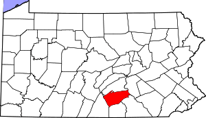 | |
| Townships | ||
| CDPs | ||
| Unincorporated communities | ||
| Footnotes | ‡This populated place also has portions in an adjacent county or counties | |
| Authority control |
|
|---|