Le Roy Township, Coffey County, Kansas
Le Roy Township is a township in Coffey County, Kansas, United States. As of the 2000 census, its population was 669.
Le Roy Township | |
|---|---|
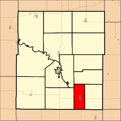 Location in Coffey County | |
| Coordinates: 38°05′23″N 095°38′15″W | |
| Country | United States |
| State | Kansas |
| County | Coffey |
| Area | |
| • Total | 21.08 sq mi (54.59 km2) |
| • Land | 20.99 sq mi (54.38 km2) |
| • Water | 0.08 sq mi (0.21 km2) 0.38% |
| Elevation | 1,007 ft (307 m) |
| Population (2000) | |
| • Total | 669 |
| • Density | 31.9/sq mi (12.3/km2) |
| GNIS feature ID | 0478092 |
Geography
Le Roy Township covers an area of 21.08 square miles (54.6 km2) and contains one incorporated settlement, Le Roy. According to the USGS, it contains one cemetery, Le Roy.
The streams of Crooked Creek and Duck Creek run through this township.
Transportation
Le Roy Township contains one airport or landing strip, Leroy Airport.
External links
Municipalities and communities of Coffey County, Kansas, United States | ||
|---|---|---|
| Cities | 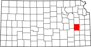 Map of Kansas highlighting Coffey County | |
| Unincorporated communities |
| |
| Townships | ||
This article is issued from Wikipedia. The text is licensed under Creative Commons - Attribution - Sharealike. Additional terms may apply for the media files.