Lavaudieu
Lavaudieu is a commune in the Haute-Loire department in south-central France.
Lavaudieu | |
|---|---|
Commune | |
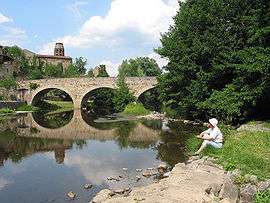 Bridge on the Senouire River and St. André abbey. | |
 Coat of arms | |
Location of Lavaudieu 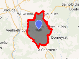
| |
 Lavaudieu  Lavaudieu | |
| Coordinates: 45°15′49″N 3°27′17″E | |
| Country | France |
| Region | Auvergne-Rhône-Alpes |
| Department | Haute-Loire |
| Arrondissement | Brioude |
| Canton | Brioude |
| Government | |
| • Mayor (2014–2020) | Pascal Piroux |
| Area 1 | 17.54 km2 (6.77 sq mi) |
| Population (2017-01-01)[1] | 243 |
| • Density | 14/km2 (36/sq mi) |
| Time zone | UTC+01:00 (CET) |
| • Summer (DST) | UTC+02:00 (CEST) |
| INSEE/Postal code | 43117 /43100 |
| Elevation | 438–727 m (1,437–2,385 ft) (avg. 550 m or 1,800 ft) |
| 1 French Land Register data, which excludes lakes, ponds, glaciers > 1 km2 (0.386 sq mi or 247 acres) and river estuaries. | |
Geography
The village lies on the right bank of the Senouire, which flows west through the commune.
Population
| Historical population | ||
|---|---|---|
| Year | Pop. | ±% |
| 1793 | 764 | — |
| 1806 | 705 | −7.7% |
| 1821 | 671 | −4.8% |
| 1831 | 771 | +14.9% |
| 1841 | 856 | +11.0% |
| 1851 | 833 | −2.7% |
| 1861 | 801 | −3.8% |
| 1872 | 764 | −4.6% |
| 1881 | 762 | −0.3% |
| 1891 | 658 | −13.6% |
| 1901 | 620 | −5.8% |
| 1911 | 521 | −16.0% |
| 1921 | 440 | −15.5% |
| 1931 | 415 | −5.7% |
| 1946 | 342 | −17.6% |
| 1954 | 299 | −12.6% |
| 1962 | 258 | −13.7% |
| 1968 | 242 | −6.2% |
| 1975 | 229 | −5.4% |
| 1982 | 237 | +3.5% |
| 1990 | 238 | +0.4% |
| 1999 | 225 | −5.5% |
| 2008 | 228 | +1.3% |
| 2017 | 243 | +6.6% |
Sights
- Romanesque Lavaudieu Abbey, otherwise Lavaudieu Priory (Abbaye Saint-André de Lavaudieu), built by St Robert, the first abbot of La Chaise-Dieu, in the 11th century,[2] which was at first a Benedictine priory, and later a house of secular canonesses from the Auvergnat nobility. It was raised to the status of abbey in 1719.
References
- "Populations légales 2017". INSEE. Retrieved 6 January 2020.
- Michelin Guide review
See also
| Wikimedia Commons has media related to Lavaudieu. |
| Authority control |
|
|---|
This article is issued from Wikipedia. The text is licensed under Creative Commons - Attribution - Sharealike. Additional terms may apply for the media files.