Lauterach (Württemberg)
Lauterach is a town in the district of Alb-Donau in Baden-Württemberg in Germany. It is located at the edge of the Swabian Jura, where the Great Lauter flows into the Danube, about 35 km southwest of Ulm.
Lauterach | |
|---|---|
_Wappen.png) Coat of arms | |
Location of Lauterach within Alb-Donau-Kreis district   | |
 Lauterach  Lauterach | |
| Coordinates: 48°15′20″N 9°34′54″E | |
| Country | Germany |
| State | Baden-Württemberg |
| Admin. region | Tübingen |
| District | Alb-Donau-Kreis |
| Government | |
| • Mayor | Bernhard Ritzler |
| Area | |
| • Total | 13.77 km2 (5.32 sq mi) |
| Elevation | 518 m (1,699 ft) |
| Population (2018-12-31)[1] | |
| • Total | 569 |
| • Density | 41/km2 (110/sq mi) |
| Time zone | CET/CEST (UTC+1/+2) |
| Postal codes | 89584 |
| Dialling codes | 07375 |
| Vehicle registration | UL |
| Website | www.gemeinde-lauterach.de |
The municipality borders in the north and east on Ehingen, in the south on Untermarchtal and Obermarchtal, as well as in the west on Rechtenstein and Emeringen. In addition to Lauterach, the community also includes the districts of Neuburg, Talheim and Reichenstein.
History
Lauterach, whose name is derived from the river name Lauter, was first mentioned in 1229. After various changing dominions, the area finally reached Württemberg in 1803 (except for Talheim, which followed in 1806). With the establishment of the Oberamt Zwiefalten in 1809, the present day community area was assigned to it, but by 1810 it had already been transferred to the Oberamt Ehingen. Since the communal reorganization in 1938, Lauterach belonged to the administrative district of Ehingen, which merged into the Alb-Danube district on 1 January 1973. In 1973, the municipality joined the Munderkingen administrative community and was thus able to maintain its independence.
Main sights
- Burg Reichenstein (Reichenstein castle ruins)
- Mühlenweiler Laufenmühle, in the Lauter valley with a small open-air museum. The preserved tuff stone sawing machine reminds of the limestone sinter mining in the Lauter valley.
Gallery
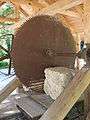 Stone sawmill
 Lauterfall
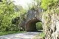 Lauter valley near Lauterach
References
- "Bevölkerung nach Nationalität und Geschlecht am 31. Dezember 2018". Statistisches Landesamt Baden-Württemberg (in German). July 2019.
| Authority control |
|
|---|