Lalbagh Thana
Lalbagh (Bengali: লালবাগ) is a neighbourhood of Dhaka District in the division of Dhaka, Bangladesh.[1]
Lalbagh লালবাগ | |
|---|---|
Thana | |
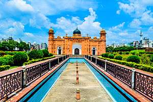 Skyline of Lalbagh, Bangladesh | |
 Lalbagh Location in Bangladesh | |
| Coordinates: 23°43′N 90°23.8′E | |
| Country | |
| Division | Dhaka Division |
| District | Dhaka District |
| Area | |
| • Total | 9.14 km2 (3.53 sq mi) |
| Population (1991) | |
| • Total | 401,387 |
| • Density | 43,915/km2 (113,740/sq mi) |
| Time zone | UTC+6 (BST) |
| Website | bangladesh |
Geography
Lalbagh is located at 23° 42' N, 90° 22' E. It was formerly larger, with a total area of 9.14 square kilometres (3.53 sq mi). The district has since split, with a population density of 168,151 people per square km, 369,933 inhabitants in its 2.2 square kilometres (0.85 sq mi) area per 2011 census making it most densely populated administrative subdivision of world.
Banks
Almost every bank operating in the country has an outlet in Lalbagh. Foreign banks such as Citi, and Standard Chartered also have branches there.
Markets
1.Chowk Bazaar 2.Moulvibazar Branch[2]
Lalbagh Police Station is located at Road No.: 17, Shahid Nagar, Dhaka, Bangladesh.
References
- Syed Shabbir Ahmed (2012). "Lalbagh Thana". In Sirajul Islam and Ahmed A. Jamal (ed.). Banglapedia: National Encyclopedia of Bangladesh (Second ed.). Asiatic Society of Bangladesh.
- "Bangladesh: Administrative Division". Archived from the original on 2015-06-20. Retrieved 2014-07-16.
This article is issued from Wikipedia. The text is licensed under Creative Commons - Attribution - Sharealike. Additional terms may apply for the media files.