Laksefjorden
Laksefjorden (English: Lakse Fjord;[1][2][3] Northern Sami: Lágesvuotna) is a fjord located entirely in Lebesby Municipality in Troms og Finnmark county, Norway. At 72 kilometres (45 mi) long, it is the third-longest fjord in Finnmark county after the Porsangerfjorden and Varangerfjorden. The fjord is situated in a sparsely populated area, with only few and small settlements along the fjord, including Lebesby, Kunes, Ifjord, and Veidnes. The fjord is surrounded by the Sværholt Peninsula to the west and the Nordkinn Peninsula to the east, and it empties to the north into the Barents Sea. Norwegian County Road 888 follows the southern and eastern shoreline of the fjord.[4]
| Laksefjorden | |
|---|---|
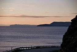 View of the fjord | |
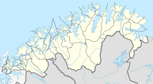 Laksefjorden Location of the fjord  Laksefjorden Laksefjorden (Norway) | |
| Location | Troms og Finnmark county, Norway |
| Coordinates | 70.7158°N 26.9013°E |
| Type | Fjord |
| Native name | Lágesvuotna (Northern Sami) |
| Basin countries | Norway |
| Max. length | 72 kilometres (45 mi) |
| Max. width | 30 kilometres (19 mi) |
See also
References
- Amundsen, Colin (2014). "Coupled Fishing and Natural Systems: A New Perspective on Early Fishing and Fishing Cultures of Northern Norway". In Harrison, Ramona; Maher, Ruth A. (eds.). Human Ecodynamics in the North Atlantic: A Collaborative Model of Humans and Nature through Space and Time. Lanham, MD: Lexington Books. pp. 55–78.
- Corona, Laurel (2000). Norway. San Diego, CA: Lucent Books. p. 16.
- Sackett, Elisabeth; Jones, Hannah Kate (2004). Children's World Atlas. New York: Barnes & Noble. p. 164.
- Store norske leksikon. "Laksefjorden" (in Norwegian). Retrieved 2013-02-18.
| Authority control |
|
|---|
This article is issued from Wikipedia. The text is licensed under Creative Commons - Attribution - Sharealike. Additional terms may apply for the media files.