Lake Vyrnwy
Lake Vyrnwy (Welsh: Llyn Efyrnwy, pronounced [ɛˈvərnʊɨ] or Llyn Llanwddyn) is a reservoir in Powys, Wales, built in the 1880s for Liverpool Corporation Waterworks to supply Liverpool with fresh water. It flooded the head of the Vyrnwy (Welsh: Afon Efyrnwy) valley and submerged the village of Llanwddyn.
| Lake Vyrnwy | |
|---|---|
| Welsh: Llyn Efyrnwy | |
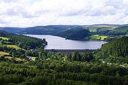 View overlooking Lake Vyrnwy showing the full extent of the lake | |
| Location | Wales |
| Coordinates | 52.78°N 3.50°W |
| Lake type | Reservoir |
| Primary inflows | River Vyrnwy and other small streams |
| Primary outflows | River Vyrnwy |
| Managing agency | Severn Trent Water |
| Built | 1881–88 |
| Max. length | 7.64 kilometres (4.75 mi) |
| Max. width | 0.80 kilometres (0.5 mi) |
| Surface area | 4.54 square kilometres (1,121 acres) |
| Max. depth | 26 metres (84 ft) |
| Water volume | 59.7 gigalitres (13.125×10⁹ imp gal) |
| Shore length1 | 19 kilometres (12 mi) |
| 1 Shore length is not a well-defined measure. | |
The Lake Vyrnwy Nature Reserve and Estate that surrounds the lake is jointly managed by the Royal Society for the Protection of Birds (RSPB) and Severn Trent Water and is a popular destination for ornithologists, cyclists and hikers. The reserve is designated as a national nature reserve, a Site of Special Scientific Interest, a Special Protection Area, and a Special Area of Conservation.
Geography
Lake Vyrnwy is a reservoir in Powys, Wales, created in 1888, by flooding the head of the river Vyrnwy (Welsh: Afon Efyrnwy) valley. It submerged the old village of Llanwddyn. The river flows from the dam into Shropshire where it converges with the River Severn near the village of Melverley on the Welsh border and ouflows into the Bristol Channel.
When the reservoir is full, it is 26 metres (84 ft) deep, contains 59.7 gigalitres (13.125×10⁹ imp gal), and covers an area of 4.54 square kilometres (1,121 acres),[1] the equivalent of around 600 football pitches. The lake has a perimeter of 19 kilometres (12 mi) with a road that goes all the way around it. Its length is 7.64 kilometres (4.75 mi). On a clear day the lake, along with many others in North Wales, can be seen from space.
311 brooks, waterfalls and rivers flow into the lake and are named after the mountains or hillsides they flow from. The main ones, clockwise from the west side of the dam, are named Afon Hirddu, Eunant, Afon Eiddew, Afon Naedroedd, Afon Cedig and Afon Y Dolau Gwynionew.
On the northern edge of the lake is a small hamlet called Rhiwargor where the rivers Afon Eiddew and Afon Naedroedd meet. Up the valley of Afon Eiddew is a waterfall known locally as Pistyll Rhyd-y-meincau, commonly known as Rhiwargor waterfall.
Construction


In 1879, George Deacon was instructed to prepare the parliamentary plans for the Vyrnwy Dam. The valley was chosen because of its size, favourable geology and its source, the River Vyrnwy, having a large water catchment area.
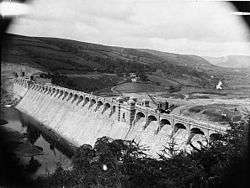
Thomas Hawksley was appointed as engineer-in-chief and prepared the design for a stone dam.[2] Dam construction with great blocks of Welsh slate started in 1881 and was completed in 1888. Hawksley resigned in 1885 because of a conflict with George Deacon who was appointed as joint engineer. The dam was the first large stone-built dam in the United Kingdom and cost £620,000 (equivalent to £70 million in 2016[3]). Earlier dams in Britain had been built using great earth embankments to hold back the water. In 1889, shortly after completion, the lake was stocked with 400,000 Loch Leven trout.
Between 1881-92 the aqueducts carrying water to Liverpool were constructed.
Description
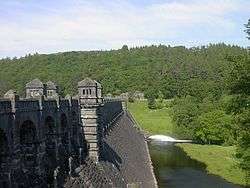
The Vyrnwy dam is 45 metres (146 ft) high from the bottom of the valley, and 37 metres (120 ft) thick at the base; it is 355 metres (1,165 ft) long and has a road bridge running along the top. It is decorated with over 25 arches and two small towers each with four corner turrets rising 4.3 metres (14 ft) above the road surface.
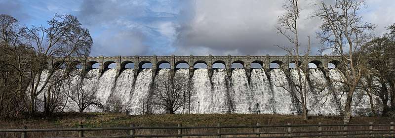
The dam was the first to carry water over its crest instead of in a channel at the side. At the bottom of the dam is a body of water known as a stilling basin necessary to absorb the energy when the water flows over the crest and into the valley, and to stop the water eroding the foundations of the dam.
A power house located under the west tower contains an electrical generator driven by water leaving the reservoir. Before mains electricity arrived in the 1960s this was the area's only source of power.
About 1,200 metres (0.75 mi) from the dam is the reservoir's straining tower. Standing only 30 metres (98 ft) from the shore, its purpose is to filter or strain out material in the water with a fine metal mesh, before the water flows along the aqueduct to Liverpool. Its architecture represents Gothic revival, built at the same time as the dam. The tower as a whole is 47 metres (154 ft) tall, 32 metres (104 ft) of which is above top water level, and is topped with a pointed copper-clad roof, coloured light green.
The west and east towers release compensation water by huge valves, which flows into for the River Vyrnwy, which would otherwise dry out unless in flood. Depending on the water levels downstream the reservoir can release anything from 25 to 45 megalitres (5,500,000 to 9,900,000 imp gal) of compensation water per day. The flow is measured by the Environment Agency at a weir a few hundred metres downstream.
Water supply


19th century
The water from Lake Vyrnwy is carried 109 kilometres (68 mi) in the Vyrnwy Large Diameter Trunk Main (LDTM) aqueduct which originally consisted of two pipelines, made largely of cast iron. To help maintenance work on the 2.7 metres (9 ft) diameter cast-iron tunnel which took the aqueduct under the Mersey, riveted steel piping was also used, which was to become the norm for trunk water-main piping.
The aqueducts cross the valley floor near Penybontfawr and then runs north of Llanrhaeadr-ym-Mochnant and Efail-rhyd on the north-east of the Tanat Valley. The aqueducts are largely underground although there are some visible surface features including air valves, the Cileos valve house, the Parc-uchaf balancing reservoirs, and a deep cutting to the west of Llanrhaeadr-ym-Mochnant.
Brick and concrete-lined tunnels carried pipes at Hirnant, Cynynion and Llanforda, and a fourth later added at Aber, so that the Hirnant tunnel could be made accessible for maintenance.
20th century
From 1926-38 the first section of a third pipeline was laid using bituminous-coated steel.[4] in 1946, a fourth pipeline was added south of Oswestry to increase capacity to 227 million litres per day.[4]
In 1978-81, the pipe crossings beneath the Mersey and the Manchester Ship Canal were reorganised. After privatisation of the water companies, responsibility for the Vyrnwy Dam and associated structures fell to Severn Trent Water. The rights to the water abstraction are with United Utilities for drinking water supply to Liverpool.
21st century
In 2013, United Utilities commenced a major refurbishment of the entire 240 km of the LDTM aqueduct, which was scheduled for completion in 2020.[5] As of 2014 water provision relied on three parallel, 80 km long gravity pipelines, 1.1 metres (42 in) in diameter delivering up to 230,000 cubic metres (50×106 imp gal) per day into reservoirs at Prescot, east of Liverpool, which supplied 900,00 customers in Cheshire and Merseyside.[6]
Nature reserve and conservation
Lake Vyrnwy is a designated Nature Reserve. The RSPB has several bird hides around the lake, where a number of rare species of birds are known to be breeding, including the peregrine falcon, the pied flycatcher, the redstart, the siskin and the wood warbler. Every spring they host a dawn chorus tour.
Around 90 species of bird have been recorded as breeding on the reserve, and six species of bat, including the pipistrelle and brown long-eared bat. Butterfly species include purple hairstreaks, commas and peacocks. Dragonflies include golden ringed, common hawker and four spotted chaser.
Managing the moorland helps improve the habitat for red grouse and the short-eared owl. Heather moorland which grows on the mountains around the lake is now being restored. In the past, heather was burnt, cut and the seeds collected to be sowed where the heather has gone. Burning at the Lake Vyrnwy moorland is no longer carried out, as the burning can have negative consequences for water management, namely water colouration.
Sheep, cattle and ponies also graze on the heather, managed by tenant farmers who farm the moorland in accordance with organic agriculture.
Broadleaf trees are being planted to replace coniferous trees, and man-made features such as hedgerows and dry-stone walls are also being restored, and wildflower areas are being restored to help insects, birds and other wildlife.
Tourism
Wood sculpture
Llanwddyn has had since 1995 a sculpture park in the valley below the dam, containing many wooden carved works. There are large wooden picnic benches in the shape of leaves and trees on the west side of the lake at Llechwedd Ddu. Near the old village on the beach is a sculpture of dolphins which, when the lake rises in a flood, appear to be jumping out of the water. Several totems are carved into standing trees and re-erected fallen trunks.[7]
Recreation
Activities in the area include sailing, hiking on Glyndŵr's Way, rock climbing, cycling, walking and horse riding.[8] The Lake Vyrnwy Half Marathon is conducted annually. The RSPB have laid out seven waymarked trails ranging from 2 to 9 kilometres (1 to 5.5 mi) in a range of habitats.
Tallest tree
The site was once home to the tallest tree in the UK, a Douglas Fir 63.79 metres (209 ft) high. This was damaged in stormy weather and had to be felled. A nearby Douglas Fir is now, at 60.62 metres (199 ft), the tallest tree in Wales.[9]
References
- "Lake Vyrnwy". The Practical Engineer. Technical Publishing Company. V. 1891. Retrieved 11 June 2014.
- Beare, T H. "Thomas Hawksley (1809-1893)". Oxford Dictionary of National Biography. Oxford University Press. Retrieved 7 November 2017.
- United Kingdom Gross Domestic Product deflator figures follow the Measuring Worth "consistent series" supplied in Thomas, Ryland; Williamson, Samuel H. (2018). "What Was the U.K. GDP Then?". MeasuringWorth. Retrieved 2 February 2020.
- "Engineering Timelines - Vyrnwy Aqueduct (1892)". engineering-timelines.com. nd. Retrieved 3 November 2019.
- "Vyrnwy water pipe works". United Utilities. Archived from the original on 18 August 2014. Retrieved 3 July 2013.
- Kevin Harvey (2014). "Vyrnwy Aqueduct Refurbishment" (PDF). WaterProjectsOnline.com.
- "The Sculpture Park at Vyrnwy". Glyn-yr-Aur. Archived from the original on 22 February 2014. Retrieved 3 July 2013.
- "Lake Vyrnwy". positivelynorthwales.com. 29 March 2016.
- "Neighbour inherits 'tallest tree' title". Archived from the original on 6 January 2014. Retrieved 15 March 2014.
External links
- Lake Vyrnwy Nature Reserve
- Lake Vyrnwy on the Powys Digital History Project
- Abandoned communities: Llanwddyn
- Lake Vyrnwy Cycle Route
- "Vyrnwy Waterworks". Graces Guide.
| Authority control |
|
|---|