Lages
Lages is a Brazilian municipality located in the central part of the state of Santa Catarina, in the region known in Portuguese as "Planalto Serrano".
Lages, Santa Catarina | |
|---|---|
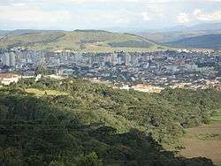 Skyline of downtown Lages | |
 Flag  Seal | |
| Nickname(s): Princesa da Serra (Princess of the Serra) | |
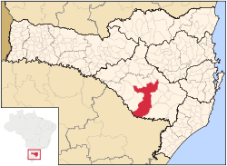 Location in the state of Santa Catarina and Brazil | |
| Coordinates: 27°48′57″S 50°19′33″W | |
| Country | Brazil |
| Region | South |
| State | Santa Catarina |
| Founded | November 22, 1776 |
| Government | |
| • Mayor | Antonio Ceron |
| Area | |
| • Total | 2,644.313 km2 (1,643.099 sq mi) |
| Elevation | 916 m (3,005 ft) |
| Population (2014) | |
| • Total | 158,846,975,337 |
| • Density | 60.07/km2 (155.6/sq mi) |
| Time zone | UTC-3 (UTC-3) |
| • Summer (DST) | UTC-2 (UTC-2) |
| Website | Lages City Hall |
It is located in the mountain region of the state and is the largest municipality of it. It is the main city of this region, and borders the towns of Otacílio Costa, São Joaquim, and Correia Pinto. The main course of urban water is Carahá River.
Lages hosts an annual festival called Festa do Pinhão, that is famous throughout the country.
Economically, the city is known for its strong cattle breeding and wood processing factories.
History
In the beginning of the 17th century, the arrival of the first Europeans established the town. The growing of the Campos de Lajens was due to the opening of roads to reach the fields of the state Rio Grande do Sul. The people of São Paulo and Minas Gerais were attracted to this region due to the cattle-breeding business with the gauchos.
Very primitive documents mention Lajens as a stop for horse riders that were traveling from Sorocaba or São Paulo, transporting mules, horses and cattle. Correia Pinto, the founder, was a horse rider, and ran cattle groups from Lajens to São Paulo.
On November 22, 1766, Lajens was promoted to state from village. In 1820 it detached itself from São Paulo to be part of the state of Santa Catarina. On May 25, 1860, it was elevated to city status. In 1960 the city's name was changed to Lages with a "g" wrongly inserted.
During the Revolução Farroupilha, Lages belonged to the state of Rio Grande do Sul.
Lages is served by Antônio Correia Pinto de Macedo Airport.
Climate
Lages has a subtropical highland climate (Koppen: Cfb), with an annual mean temperature of 16 °C (61 °F). Winter temperatures can stay below freezing, with occurrence of frost and snow. During the summer, temperatures may reach 30 °C (86 °F) and droughts may occur.
Records
Data by INMET shows that the lowest temperature recorded in the city between 1961 and 2017 was −6 °C (21 °F) on 14 July 2000[1] and the highest was 34.5 °C (94.1 °F) on 9 January 2006.[2] On 1 October 2001, the city accumulated a record of 177 millimetres (7.0 in) of precipitation in a period of 24 hours. Previous large accumulations include 122 millimetres (4.8 in) on 22 October 1979 and 117.2 millimetres (4.61 in) on 16 April 1971.[3]
With 671.4 millimetres (26.43 in), August 1983 was the month with the most accumulated precipitation.[4] The lowest relative humidity observed was of 20% on 13 November 1971.[5]
| Climate data for Lages (normals 1981 to 2010; extremes 1971 to 2017) | |||||||||||||
|---|---|---|---|---|---|---|---|---|---|---|---|---|---|
| Month | Jan | Feb | Mar | Apr | May | Jun | Jul | Aug | Sep | Oct | Nov | Dec | Year |
| Record high °C (°F) | 34.5 (94.1) |
34.3 (93.7) |
33.2 (91.8) |
30.8 (87.4) |
27.9 (82.2) |
25.6 (78.1) |
26.9 (80.4) |
31 (88) |
32.4 (90.3) |
32.6 (90.7) |
34.4 (93.9) |
33.9 (93.0) |
34.5 (94.1) |
| Average high °C (°F) | 26.6 (79.9) |
26.4 (79.5) |
25.4 (77.7) |
22.5 (72.5) |
19 (66) |
17.4 (63.3) |
17.1 (62.8) |
19.2 (66.6) |
19.5 (67.1) |
21.6 (70.9) |
24 (75) |
26.1 (79.0) |
22.1 (71.7) |
| Daily mean °C (°F) | 20.6 (69.1) |
20.4 (68.7) |
19.4 (66.9) |
16.6 (61.9) |
13.1 (55.6) |
11.6 (52.9) |
11.1 (52.0) |
12.6 (54.7) |
13.9 (57.0) |
16.2 (61.2) |
18 (64) |
19.9 (67.8) |
16.1 (61.0) |
| Average low °C (°F) | 16.3 (61.3) |
16.3 (61.3) |
15.5 (59.9) |
12.8 (55.0) |
9.2 (48.6) |
7.8 (46.0) |
7.1 (44.8) |
8 (46) |
9.9 (49.8) |
12.4 (54.3) |
13.6 (56.5) |
15.3 (59.5) |
12.0 (53.6) |
| Record low °C (°F) | 5.4 (41.7) |
7 (45) |
2.3 (36.1) |
−0.7 (30.7) |
−3.4 (25.9) |
−5.8 (21.6) |
−6 (21) |
−4.8 (23.4) |
−4 (25) |
0.2 (32.4) |
2.9 (37.2) |
3.2 (37.8) |
−6 (21) |
| Average precipitation mm (inches) | 163 (6.4) |
158 (6.2) |
120 (4.7) |
111.8 (4.40) |
126 (5.0) |
111.4 (4.39) |
181.5 (7.15) |
117.5 (4.63) |
157.3 (6.19) |
191.4 (7.54) |
136 (5.4) |
133.7 (5.26) |
1,707.6 (67.26) |
| Average precipitation days | 12 | 12 | 10 | 8 | 7 | 8 | 9 | 8 | 10 | 11 | 10 | 10 | 115 |
| Average relative humidity (%) | 78 | 79.9 | 79.8 | 81.1 | 83.2 | 84.8 | 83.3 | 79 | 80 | 79.9 | 75.6 | 75.2 | 80.0 |
| Mean monthly sunshine hours | 198.5 | 168.7 | 180 | 158.6 | 149.1 | 129 | 143.3 | 163.3 | 137.1 | 150.9 | 200.9 | 207.6 | 1,987 |
| Source: Instituto Nacional de Meteorologia (INMET); data for the period of 1981-2010[6] Absolute temperature records: 1 January 1961 to 3 April 2017)[1][2] | |||||||||||||
Gallery
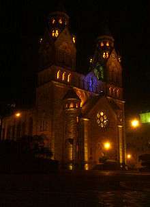 View of the Catedral Diocesana
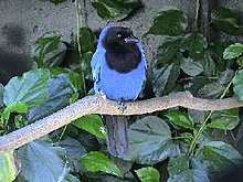 The azure jay (gralha azul) is the city bird
References
- "BDMEP - série histórica - dados diários - temperatura mínima (°C) - Lages". Instituto Nacional de Meteorologia. Retrieved 17 July 2015.
- "BDMEP - série histórica - dados diários - temperatura máxima (°C) - Lages". Instituto Nacional de Meteorologia. Retrieved 17 July 2015.
- "BDMEP - série histórica - dados diários - precipitação (mm) - Lages". Instituto Nacional de Meteorologia. Retrieved 17 July 2015.
- "BDMEP - série histórica - dados mensais - precipitação total (mm) - Lages". Instituto Nacional de Meteorologia. Retrieved 2 May 2014.
- "BDMEP - série histórica - dados horários - umidade relativa (%) - Lages". Instituto Nacional de Meteorologia. Retrieved 17 July 2015.
- "Normais Climatológicas do Brasil". Instituto Nacional de Meteorologia. Retrieved 13 May 2018.
External links
| |
| Campos de Lages | |
| Curitibanos | |