LaBarque Creek, Missouri
LaBarque Creek is an unincorporated community and census-designated place (CDP) in Jefferson County, Missouri, United States. Its population was 1,558 as of the 2010 census.[1]
LaBarque Creek, Missouri | |
|---|---|
 LaBarque Creek  LaBarque Creek | |
| Coordinates: 38°24′58″N 90°40′40″W | |
| Country | United States |
| State | Missouri |
| County | Jefferson |
| Area | |
| • Total | 17.632 sq mi (45.67 km2) |
| • Land | 17.561 sq mi (45.48 km2) |
| • Water | 0.071 sq mi (0.18 km2) |
| Elevation | 630 ft (190 m) |
| Population | |
| • Total | 1,558 |
| • Density | 89/sq mi (34.3/km2) |
| Time zone | UTC-6 (Central (CST)) |
| • Summer (DST) | UTC-5 (CDT) |
| ZIP Code | 63069 |
| Area code(s) | 636 |
| GNIS feature ID | 2583783[2] |
Geography
The community is in northwestern Jefferson County and is named for LaBarque Creek, a tributary of the Meramec River. It is located on Missouri Route F, approximately 3 miles (5 km) northwest of Byrnesville on Big River,[3] 5 miles (8 km) southwest of Eureka on Interstate 44, and 33 miles (53 km) southwest of downtown St. Louis. According to the U.S. Census Bureau, the CDP has an area of 17.632 square miles (45.67 km2); 17.561 square miles (45.48 km2) of its area is land, and 0.071 square miles (0.18 km2) is water.[1]
References
- "2010 Census Gazetteer Files - Places: Missouri". U.S. Census Bureau. Retrieved January 19, 2017.
- "LaBarque Creek Census Designated Place". Geographic Names Information System. United States Geological Survey.
- Pacific, Missouri, 7.5 Minute Topographic Quadrangle, USGS, 1954 (1984 rev.)
Municipalities and communities of Jefferson County, Missouri, United States | ||
|---|---|---|
| Cities | 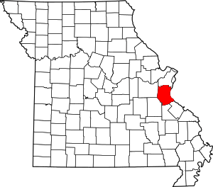 Map of Missouri highlighting Jefferson County | |
| Villages | ||
| Townships | ||
| CDPs | ||
| Unincorporated communities | ||
This article is issued from Wikipedia. The text is licensed under Creative Commons - Attribution - Sharealike. Additional terms may apply for the media files.