Kyōtanabe, Kyoto
Kyōtanabe (京田辺市, Kyōtanabe-shi) is a city located in the southern part of Kyoto Prefecture, Japan.
Kyōtanabe 京田辺市 | |
|---|---|
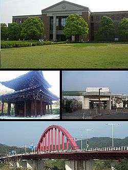 Top:A campus of Doshisha University, Middle left:Shuonan Temple, Middle right:Matsui Yamate Station, Bottom:Yamashiro Bridge | |
 Flag  Emblem | |
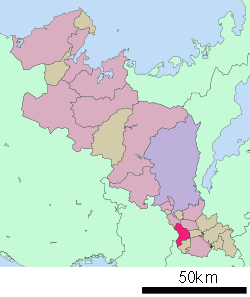 Location of Kyōtanabe in Kyoto Prefecture | |
 Kyōtanabe Location in Japan | |
| Coordinates: 34°49′N 135°46′E | |
| Country | Japan |
| Region | Kansai |
| Prefecture | Kyoto Prefecture |
| Government | |
| • Mayor | Akezo Ishii (since April 2007) |
| Area | |
| • Total | 42.92 km2 (16.57 sq mi) |
| Population (October 1, 2017) | |
| • Total | 72,493 |
| • Density | 1,700/km2 (4,400/sq mi) |
| Symbols | |
| • Tree | Triadica sebifera |
| • Flower | Rhododendron pulchrum |
| Time zone | UTC+9 (JST) |
| City hall address | Tanabe 80, Kyo-tanabe City, Kyoto Prefecture (京都府京田辺市田辺80番地) 610-0393 |
| Website | www |
As of October 1, 2017, the city has an estimated population of 72,493, with 30,901 households and a population density of 1,700 persons per km². The total area is 42.92 km².
History
Kyōtanabe was briefly the capital of Japan during the reign of Emperor Keitai. The life of the Imperial court was centered at Tsutsuki Palace where the emperor lived in 511–518.[1]
The modern city was founded on April 1, 1997, after the town of Tanabe was reorganized into the city of Kyōtanabe. The Kyō- was added to distinguish it from the city of Tanabe, Wakayama.
Geography
References
External links

- Kyotanabe City official website (in Japanese)
- Kyotanabe City official website (in English)
Kyoto (capital) | ||
| Wards of Kyoto | ||
| Cities |
| |
| Districts | ||
| Authority control |
|
|---|
This article is issued from Wikipedia. The text is licensed under Creative Commons - Attribution - Sharealike. Additional terms may apply for the media files.