Kuraginsky District
Kuraginsky District (Russian: Кура́гинский райо́н) is an administrative[1] and municipal[6] district (raion), one of the forty-three in Krasnoyarsk Krai, Russia. It is located in the southeast of the krai and borders with Balakhtinsky, Mansky, Partizansky, and Sayansky Districts in the north, Irkutsk Oblast in the northeast, the Tuva Republic in the southeast, Karatuzsky District in the south, Minusinsky District in the southwest, Krasnoturansky District in the west, and with Idrinsky Districts in the northwest. The area of the district is 24,073 square kilometers (9,295 sq mi).[2] Its administrative center is the urban locality (an urban-type settlement) of Kuragino.[1] Population: 47,690 (2010 Census);[3] 51,873 (2002 Census);[8] 54,337 (1989 Census).[9] The population of Kuragino accounts for 28.8% of the district's total population.[3]
Kuraginsky District Курагинский район | |
|---|---|
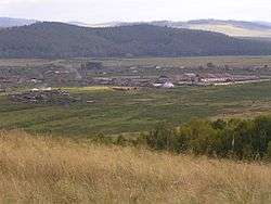 Landscape in Kuraginsky District | |
.png) Flag .png) Coat of arms | |
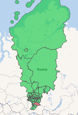
Location of Kuraginsky District in Krasnoyarsk Krai | |
| Coordinates: 53°53′51″N 92°40′21″E | |
| Country | Russia |
| Federal subject | Krasnoyarsk Krai[1] |
| Established | April 4, 1924[2] |
| Administrative center | Kuragino[1] |
| Government | |
| • Type | Local government |
| • Body | Kuraginsky District Council of Deputies[2] |
| • Head[2] | Yevgeny D. Dmitriyev[2] |
| Area | |
| • Total | 24,073 km2 (9,295 sq mi) |
| Population | |
| • Total | 47,690 |
| • Estimate (2018)[4] | 44,977 (-5.7%) |
| • Density | 2.0/km2 (5.1/sq mi) |
| • Urban | 60.3% |
| • Rural | 39.7% |
| Administrative structure | |
| • Administrative divisions | 1 District towns, 4 Urban-type settlements, 17 Selsoviets |
| • Inhabited localities[1] | 1 Cities/towns, 4 Urban-type settlements[5], 63 Rural localities |
| Municipal structure | |
| • Municipally incorporated as | Kuraginsky Municipal District[6] |
| • Municipal divisions[6] | 5 Urban settlements, 17 Rural settlements |
| Time zone | UTC+7 (MSK+4 |
| OKTMO ID | 04630000 |
| Website | http://www.kuragino-krsn.ru/ |
Geography
Kuraginsky District is the largest in terms of area in the south of Krasnoyarsk Krai. It stretches for 400 kilometers (250 mi) from west to east.
Climate in the district is strongly continental.[10] Tourist attractions include the Kinzelyuk Waterfall, one of the highest in Russia.
History
The district was founded on April 4, 1924.[2]
Government
As of 2013, the Head of the district and the Chairman of the District Council is Yevgeny D. Dmitriyev.[2]
Economy
The district is a raw-material base for the metallurgical, food-processing, and timber industries.[10]
Culture
There are thirty-nine clubs, two museums, thirty-six public libraries (with the total book stock numbering ~367,000 volumes), and three music schools.[10]
Education
Thirty-six educational facilities are located in the district.[10]
Public health services
There is one hospitals, as well as four clinics. There are on average 1.23 medical workers per 1,000 people.[10]
References
Notes
- Law #10-4765
- Official website of Krasnoyarsk Krai. Information about Kuraginsky District (in Russian)
- Russian Federal State Statistics Service (2011). "Всероссийская перепись населения 2010 года. Том 1" [2010 All-Russian Population Census, vol. 1]. Всероссийская перепись населения 2010 года [2010 All-Russia Population Census] (in Russian). Federal State Statistics Service.
- "26. Численность постоянного населения Российской Федерации по муниципальным образованиям на 1 января 2018 года". Federal State Statistics Service. Retrieved January 23, 2019.
- The count of urban-type settlements may include the work settlements, the resort settlements, the suburban (dacha) settlements, as well as urban-type settlements proper.
- Law #13-3009
- "Об исчислении времени". Официальный интернет-портал правовой информации (in Russian). June 3, 2011. Retrieved January 19, 2019.
- Russian Federal State Statistics Service (May 21, 2004). "Численность населения России, субъектов Российской Федерации в составе федеральных округов, районов, городских поселений, сельских населённых пунктов – районных центров и сельских населённых пунктов с населением 3 тысячи и более человек" [Population of Russia, Its Federal Districts, Federal Subjects, Districts, Urban Localities, Rural Localities—Administrative Centers, and Rural Localities with Population of Over 3,000] (XLS). Всероссийская перепись населения 2002 года [All-Russia Population Census of 2002] (in Russian).
- "Всесоюзная перепись населения 1989 г. Численность наличного населения союзных и автономных республик, автономных областей и округов, краёв, областей, районов, городских поселений и сёл-райцентров" [All Union Population Census of 1989: Present Population of Union and Autonomous Republics, Autonomous Oblasts and Okrugs, Krais, Oblasts, Districts, Urban Settlements, and Villages Serving as District Administrative Centers]. Всесоюзная перепись населения 1989 года [All-Union Population Census of 1989] (in Russian). Институт демографии Национального исследовательского университета: Высшая школа экономики [Institute of Demography at the National Research University: Higher School of Economics]. 1989 – via Demoscope Weekly.
- Агенство труда и занятости населения Красноярского края. Проект переселения «Курагинский район». Общая характеристика территории вселения «Курагинский район» Archived August 22, 2009, at the Wayback Machine (in Russian)
Sources
- Законодательное собрание Красноярского края. Закон №10-4765 от 10 июня 2010 г. «О перечне административно-территориальных единиц и территориальных единиц Красноярского края», в ред. Закона №7-3007 от 16 декабря 2014 г. «Об изменении административно-территориального устройства Большеулуйского района и о внесении изменений в Закон края "О перечне административно-территориальных единиц и территориальных единиц Красноярского края"». Вступил в силу 1 июля 2010 г. Опубликован: "Ведомости высших органов государственной власти Красноярского края", №33(404), 5 июля 2010 г. (Legislative Assembly of Krasnoyarsk Krai. Law #10-4765 of June 10, 2010 On the Registry of the Administrative-Territorial Units and the Territorial Units of Krasnoyarsk Krai, as amended by the Law #7-3007 of December 16, 2014 On Changing the Administrative-Territorial Structure of Bolsheuluysky District and on Amending the Krai Law "On the Registry of the Administrative-Territorial Units and the Territorial Units of Krasnoyarsk Krai". Effective as of July 1, 2010.).
- Законодательное собрание Красноярского края. Закон №13-3009 от 18 февраля 2005 г. «Об установлении границ и наделении соответствующим статусом муниципального образования Курагинский район и находящихся в его границах иных муниципальных образований», в ред. Закона №5-1826 от 21 ноября 2013 г. «О внесении изменений в Законы края об установлении границ и наделении соответствующим статусом муниципальных образований Красноярского края». Вступил в силу через десять дней после официального опубликования. Опубликован: "Ведомости высших органов государственной власти Красноярского края", №9, 4 марта 2005 г. (Legislative Assembly of Krasnoyarsk Krai. Law #13-3009 of February 18, 2005 On Establishing the Borders and Granting an Appropriate Status to the Municipal Formation of Kuraginsky District and to Other Municipal Formations Within Its Borders, as amended by the Law #5-1826 of November 21, 2013 On Amending the Krai Laws on Establishing the Borders and Granting an Appropriate Status to the Municipal Formations of Krasnoyarsk Krai. Effective as of ten days after the official publication.).