Kundapur
Kundapur, also spelt as Kundaapra, Kundapura& Coondapoor is a coastal town in the South Canara area of the Indian state of Karnataka. It is administered by the Kundapur Town Municipal Council and serves as the headquarters of the Kundapura Taluk of Udupi district.
Kundapura | |
|---|---|
Town | |
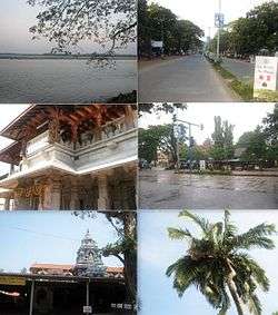 | |
 Kundapura Kundapura Town  Kundapura Kundapura (Karnataka) | |
| Coordinates: 13°37′42″N 74°41′20″E | |
| india | India |
| State | Karnataka |
| Region | Tulu Nadu |
| District | Udupi |
| Municipality | Kundapura Town Municipal Council |
| Settled | 1912 |
| Government | |
| • Type | Municipal corporation |
| Area | |
| • Total | 23.06 km2 (8.90 sq mi) |
| Elevation | 80 m (260 ft) |
| Population (2011[1]) | |
| • Total | 30,444 |
| • Density | 2,415.11/km2 (6,255.1/sq mi) |
| Languages | |
| • Official | Kannada |
| Time zone | UTC+5:30 (IST) |
| PIN | 576 201 |
| Telephone code | 91-(0)8254 |
| ISO 3166 code | IN-KA |
| Vehicle registration | KA-20 |
| Sex ratio | 1.09 ♂/♀ |
| Legislature type | Bicameral |
| Lok Sabha constituency | Udupi Loksabha Constituency (15th) |
| Vidhan Sabha constituency | Kundapur Vidhansabha Kshethra (124th) |
| Website | www |
Kundapura railway station, along the Konkan railway, is very useful for Kerala pilgrims who visit Kolluru Mookambika Temple as best transport connection to Kollur along with facilities like lodges, and many more tourist attraction such as beaches, temples, and resorts are very near to the station.
History
The name Kundapura can be traced to the Kundeshwar temple built by Kundavarma in the vicinity of the Panchagangavalli river. The name of the town may be derived from Kundavarma who ruled the area. Kunda means 'pillar' in kannada,[2] which refers to the traditional method of constructing houses. Pura means town.In additional the word "Kunda" also refers to the flower Jasmine.Where the Majority people of Kundapura grow flower Jasmine in this region which came to be called as kundapura(Land of Jasmine). Kundapura is surrounded by water from three sides. To the north lies the Panchagangavali river. To the east lies the Kalaghar river. To the west lie the Kodi backwaters and the Arabian Sea, leaving the south side as the main connecting land mass. All connecting roads to Kundapura enter the city from the southern direction. North side of the town is vast backwaters of Panchagangavali river and a bridge has been constructed across it.
Language
The town mainly consists of speakers of Kundagannada dialect of Kannada. Also, there are few Konkani and Tulu speakers. Hindus belonging to Saraswat Brahmin, Mestha, Kharvi, and goldsmith castes, and Mangalorean Catholics speak Konkani.
Demographics
As of the 2001 India census,[3]
- Kundapur has a population of 30,450.
- Males constitute 49% of the population and females 51%.
- Literacy rate of 92%, higher than the national average of 59.5%: male literacy is 94%, and female literacy is 88%.
- 9% of the population are under 6 years of age.
Transport
Kundapur is well connected to other parts of the country by NH66. SH52 is the main State Highway that connects to Shimoga District. This Highway connects cities and towns of different states. Kundapur is also connected to the Konkan Railway, which runs from Mumbai to Mangalore. The railway station is about 4 kilometres (2.5 mi) from the town. The nearest airport is Mangalore International Airport, situated at Bajpe around 87 kilometres (54 mi) from Kundapur.
Kundapur is located at a distance of 38 km (24 mi) from Udupi, 40 km (25 mi) from Manipal, 54 km (34 mi) from Bhatkal, 91 km (57 mi) from Mangalore and 181 km (112 mi) from Karwar, which are the other major cities/towns in Coastal Karnataka.
The major part of transportation around the town are private local buses and some out of the town is serviced by government owned. A High frequency of buses can be found for Udupi and Mangalore, and there are multiple bus stands in the town. The main bus stand where all the buses to Udupi and Mangalore are available is called "New bus stand", and is located near the police station. Another frequently used mode of transportation is auto rikshaw.
References
| Wikivoyage has a travel guide for Kundapur. |
| Wikimedia Commons has media related to Kundapura. |
- "Villages & Towns in Kundapura Taluka of Udupi, Karnataka". www.census2011.co.in. Retrieved 12 November 2016.
- Kittel, Ferdinand (1999). A Kannada-English dictionary. Asian Educational Services. p. 441. ISBN 81-206-0049-5.
- "Census of India 2001: Data from the 2001 Census, including cities, villages and towns (Provisional)". Census Commission of India. Archived from the original on 16 June 2004. Retrieved 1 November 2008.
| Taluks |
|
|---|---|
| Places |
|
| Temples |
|
| Udupi cuisines | |
| Society | |
| Beaches |
|