Kotla, Bagh
Kotla (Urdu: کوٹلہ) is a village and tourist resort in Bagh District, Azad Kashmir, Pakistan. Kotla is 6,560 feet (2,000 m) above sea level. Kotla contains pine trees that are hundreds of years old. It takes approximately 1 hour to drive from Bagh to Kotla.
Kotla | |
|---|---|
Village | |
 Kotla | |
| Coordinates: 34.0255°N 73.8291°E | |
| Country | |
| State | Azad Kashmir |
| District | Bagh |
| Elevation | 2,000 m (6,500 ft) |
| Languages | |
| • Official | Urdu |
| Time zone | PST |
Forests
Kotla is also home to some of the rarest forests in the region containing Pine trees that are hundreds of years old. Due to lack of knowledge/interest, these forests are now endangered to become extinct as locals continue deforestation by cutting down trees yet local/state governments seem to have no interest in saving them.

Geography
The village is situated on the confluence of two mini nullahs, Jaber Nala and Manjimar, which flow all the year round. Kotla is 18 km from the city of Bagh and is located in a valley surrounded by large mountains on three sides. On the south of the valley lies Kanthi Forest. The northern area of Kotla borders Muzaffarabad District. Kotla is the central point of the Sharqi area.
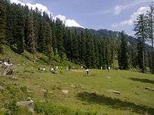
Tourism

Kotla is famous for its hiking trails that lead to Pir Kanthi 10,930 feet (3,330 m), Danna meadows, Panjal Mastan and Ganga Choti, a mountain peak at about 9,989 feet (3,045 m) and one of the most famous tourist attractions in AJK, Pakistan.
Kotla Waterfalls
Kotla Watterfalls is located in Kotla village. It is a very large waterfall. It is located at a height of 5798 feet above sea level. The waterfall drops about 150 metres (492 ft) from a hanging valley that ends in overhanging cliffs above the Kotla River. The Valley of the Bagh is located at a height of 5798 feet above sea level.
The stream, on reaching the verge of the rocky walls of the valley, forms a cascade so high that it is almost lost in spray before it reaches the level of the valley. After rain, and early in the season when fed by the melting snows, Kotla Falls is very striking. The force of the stream above the fall at such times is sufficient to carry the water clear of the precipice, and the whole mass descends in a condition of liquid dust, between spray and cloud, that sways to and fro with the gentlest breeze. In a dry summer, when the supply of water is much reduced, the effect is comparatively insignificant. The height of the cascade is between 300 and 400 ft, one of the highest in Kashmir formed of a single unbroken fall.
Danna
Danna is a hilltop area situated in Tehsil Bagh in the Bagh District of Azad Kashmir. Its approximate height is about 9,400 feet (2,900 m) above sea level. RWkot, MZD, Kazinag Glacier (15,000 ft) and Jhulem River can be viewed from Danna. Danna is the highest mountainous location in the northeastern area of Bagh, and near Kotla. it is the point of origin of three different mountain ridges. There are some remains of an old mazar on the highest hilltop. Danna is most accessible during the summer months; the weather is generally pleasant but becomes colder from October through March.
Danni Sar (Lake)
Danni Sar is a high-altitude lake (2,612 metres 8,571 ft) located near Kotla Bagh, Azad Kashmir.
Pir Kanthi
Pīr Kanthi is a peak and is located in near Kotla village. The elevation above sea level is 3321 metres.
Ganga Choti
Ganga Peak, more commonly known as Ganga Choti among locals, is located in the Bagh district of Azad Kashmir. It is also visible from Bagh city and is often called "the Crown of Bagh". Ganga Choti is approachable from Sudhan Gali and Kotla, Dist Bagh, it is four hours trek and it is strenuous trek since you have to gain height at every step as there is very scant flat ground on this trek. Ganga Choti is a peak village Bani Minhasan and Kotla in Bagh District, Azad Kashmir, Pakistan. It is 9989 feet (3045 meters) high. It is an attraction for tourists in that area. It is situated in the Pir Panjal Range.
The hike for Ganga peak starts from the town of Sudhan Gali and Kotla which is at a height of 2200 meters above sea level. From there, the peak can be reached through a 3–4 hours easy hike. People in Chanari climb Ganga from that side.
The hike to Ganga offers views of the valley and meadows. From the peak, there is a 360-degree panoramic view of the whole area. The nearest peak higher from Ganga Peak is called Pir Kanthi, which is at an aerial distance of about 10 km from it.
Peaks
There are seven peaks around in the Kotla village.
| Serial no | Peak | Height in ft | Height in mt |
|---|---|---|---|
| 01 | Pir Kanthi | 10930 | 3331 |
| 02 | Ganga Choti | 9989 | 3044 |
| 03 | Kobra | 9875 | 3009 |
| 04 | Naza Gali | 9858 | 2791 |
| 05 | Nanga Pir Peak | 8576 | 2611 |
| 06 | Danna | 9450 | 2880 |
| 07 | Sank | 10825 | 3300 |
Culture
Kotla has a population of about 7,00 Maldiyal Mughal are the dominant tribe of Kotla with a good number of Maldyal.
The majority of the Maldyal Mughals speak Pahari and Potohari. Their culture is mirror of typical Pahari culture. Their population is a majority of Muslim with a sizable (Shia) minority.
Maldiyal Mughal
The Maldiyal is a Mughal clan, living in Azad Kashmir and Rawalpindi division of Punjab, Pakistan and Jammu and Kashmir division, and Punjab regions of India. It is a major land-holding tribe in Bagh District and Tehsil Abbaspur of the Poonch District and Tehsil Mendhar of District Poonch of Indian Jammu and Kashmir. The main village of Maldiyal is birpani, Kotla, Topi Kothian & Narr Sher Ali Khan, moere than 95% population of these areas is Maldiyal The word "Maldyal" is derived from the name of Mirza Moloud Baig, Father of Maldyals and a great warrior of Poonch State.
- Shajra of Mirza Moloud Baig
A short introduction from Ameer Taimoor Gorgani Barlasi. The great Mughal Emperor to Mirza Moloud Baig.
Ameer Taimoor Gorgania Barlasi, the great Mughal Emperor
- Ameerzada Umer Sheikh Gorgani
- Mirza Baiqra
- Ghiaath-Ud-Din Mansoor Mirza
- Ghazi Hussain Mirza
- Badih-Uz-Zaman Mirza
- Muhammad Yaadgar Mirza
- Mirza Tahir Baig
- Mirza Mouloud Baig
The tribe has a history of bravery and martiality. The tribe is descended from Prince Mirza Tahir Baig, who immigrated from Herat in Afghanistan, which was the largest province of Taimoorid Sultanate, and settled in Srinagar. Later, the Maldyal Tribe settled in Poonch.
Climate
Kotla features a subtropical highland climate (Cwa) under the Köppen climate classification due to high altitude. Kotla has mild to warm temperatures during the spring and autumn, humid temperatures during summer and cold to snowy during the winter. The temperature can rise as high as 38 °C (100 °F) during the mid-summer months and drop below −10 °C (14 °F) during the winter months. Snowfall can occur in December and January, while most rainfall occurs during the monsoon season stretching from July to September.[1]
| Climate data for Kotla, Azad Kashmir | |||||||||||||
|---|---|---|---|---|---|---|---|---|---|---|---|---|---|
| Month | Jan | Feb | Mar | Apr | May | Jun | Jul | Aug | Sep | Oct | Nov | Dec | Year |
| Record high °C (°F) | 19.6 (67.3) |
20.9 (69.6) |
30.4 (86.7) |
41 (106) |
45 (113) |
40.6 (105.1) |
43.2 (109.8) |
40 (104) |
36.4 (97.5) |
35.9 (96.6) |
33.3 (91.9) |
25.9 (78.6) |
45 (113) |
| Average high °C (°F) | 17.3 (63.1) |
19.8 (67.6) |
24.7 (76.5) |
30.6 (87.1) |
36.3 (97.3) |
38.1 (100.6) |
34.8 (94.6) |
33.5 (92.3) |
33.2 (91.8) |
30.4 (86.7) |
25.2 (77.4) |
19.7 (67.5) |
28.6 (83.5) |
| Average low °C (°F) | 3.8 (38.8) |
6.7 (44.1) |
11.1 (52.0) |
15.9 (60.6) |
21 (70) |
23.8 (74.8) |
24.3 (75.7) |
23.6 (74.5) |
21.1 (70.0) |
14.8 (58.6) |
8.8 (47.8) |
5 (41) |
15.0 (59.0) |
| Record low °C (°F) | −10 (14) |
−5.6 (21.9) |
−3.8 (25.2) |
1.3 (34.3) |
10 (50) |
13 (55) |
12 (54) |
12.7 (54.9) |
13 (55) |
1.9 (35.4) |
0 (32) |
−3.3 (26.1) |
−10 (14) |
| Average rainfall mm (inches) | 24.9 (0.98) |
30.8 (1.21) |
31.2 (1.23) |
20.1 (0.79) |
14.4 (0.57) |
44.1 (1.74) |
112.8 (4.44) |
136.3 (5.37) |
43.8 (1.72) |
15.7 (0.62) |
14.5 (0.57) |
19.1 (0.75) |
507.7 (19.99) |
| Source: [2] | |||||||||||||
Sports
There is a cricket ground near the Dana known as Kotla Ground, located between two mountains. Every year in June a cricket tournament is held there in which sixteen teams of District Bagh and Mzd participate.
Earthquake of 2005
Kotla and its surrounding villages were totally destroyed by the 2005 Kashmir earthquake, hundreds of people were killed or injured by this quake. 100% population was left homeless. Most of the houses have been reconstructed though with the help of the Governments of Pakistan, Azad Kashmir and local and international NGOs.
References
- "Pakistan Meteorological Department". Archived from the original on 2012-01-20. Retrieved 2020-02-19.
- "Kotla, Azad Kashmir". Climate Charts. Retrieved 14 June 2013.