Koritnica (river)
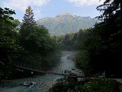
The Koritnica (pronounced [kɔˈɾiːtnitsa]; Italian: Coritenza[1]), with a length slightly over 16 kilometers (9.9 mi), is a right tributary of the Soča River.[2] It flows west through the Log Koritnica Valley (Slovene: Loška Koritnica) south of Mount Mangart and then turns south near Log pod Mangartom, flowing past the Kluže Fortress and through the 70-meter (230 ft) deep and 200-meter (660 ft) long Kluže Canyon (korita Kluže), also known as the Koritnica Canyon (korita Koritnice).[3] It empties into the Soča southeast of Bovec.
| Koritnica | |
|---|---|
 | |
| Location | |
| Country | Slovenia |
| Physical characteristics | |
| Source | |
| ⁃ location | Julian Alps, south of Mount Mangart |
| Mouth | |
⁃ location | Soča River, southeast of Bovec |
⁃ coordinates | 46°19′48.74″N 13°34′31.67″E |
| Basin features | |
| Progression | Soča→ Adriatic Sea |
See also
References
- Pavan, Camillo. 1997. Caporetto: storia, testimonianze, itinerari. Treviso: author, p. 450.
- The Koritnica River on Geopedia
- Turistično informacijski center Bovec: Reka Koritnica.
External links
- The Koritnica River on Geopedia (in Slovene)

Hydrography of Slovenia | ||
|---|---|---|
| Rivers |
|  |
| Streams | ||
| Waterfalls | ||
| Lakes | ||
| Wetlands | ||
| Sea | ||
| River valleys |
| |
| Canyons and gorges |
| |
This article is issued from Wikipedia. The text is licensed under Creative Commons - Attribution - Sharealike. Additional terms may apply for the media files.