Kolguyev Island
Kolguyev Island (Russian: о́стров Колгу́ев) is an island in Nenets Autonomous Okrug Russia located in the south-eastern Barents Sea (west of the Pechora Sea) to the north-east of the Kanin Peninsula.[1]
| Native name: о́стров Колгу́ев | |
|---|---|
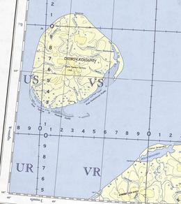 Kolguyev Island. 1963 U.S. Army map section | |
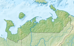 Kolguyev Island Location of Kolguyev Island in the Nenets Autonomous Okrug | |
| Geography | |
| Location | Arctic Sea |
| Coordinates | 69°05′N 49°15′E |
| Area | 3,497 km2 (1,350 sq mi) |
| Highest elevation | 166 m (545 ft) |
| Highest point | Gora Paarkov-Sarlopy |
| Administration | |
Russia | |
| Oblast | Arkhangelsk Oblast |
| Okrug | Nenets Autonomous Okrug |
| Largest settlement | Bugrino (pop. 210) |
| Demographics | |
| Population | 300 |
| Ethnic groups | Nenets |
Geography
The approximately circular-shaped island has a diameter of 80 kilometres (50 mi) and is 3,497 square kilometres (1,350 sq mi) in area. The highest point on the island is at 166 m (545 feet). The vast wetland consists of many bogs and morainic hills, covered by vegetation characteristic of the tundra. Notably, a proposed subspecies of the Candle Larkspur, Delphinium elatum ssp. cryophilum, is only found on this island, but its distinctness from the mainland population is disputed.
There is only one inhabited settlement on the island, Bugrino, located on the southeast coast. Nenets form the majority of the population, with fishing, reindeer farming and trapping being their main economic activities. Oil and gas are also present.
Climate
Kolguyev Island has a tundra climate (ET) with an August mean of only 7.7.
Highest Temperature: 30.0 °C (86.0 °F) on July 10, 1990
Lowest Temperature: −40.1 °C (−40.2 °F) on February 16, 1951
Warmest Month: 13.0 °C (55.4 °F) on July, 2016
Coldest Month: −25.3 °C (−13.5 °F) on February, 1998
Wettest Year: 506 millimetres (19.9 in) in 1962
Driest Year: 101 millimetres (4.0 in) in 2017
| Climate data for Kolguyev Island (Climate ID:22095) | |||||||||||||
|---|---|---|---|---|---|---|---|---|---|---|---|---|---|
| Month | Jan | Feb | Mar | Apr | May | Jun | Jul | Aug | Sep | Oct | Nov | Dec | Year |
| Record high °C (°F) | 2.3 (36.1) |
1.7 (35.1) |
2.3 (36.1) |
8.3 (46.9) |
18.0 (64.4) |
27.4 (81.3) |
30.0 (86.0) |
29.2 (84.6) |
20.3 (68.5) |
12.0 (53.6) |
5.8 (42.4) |
4.4 (39.9) |
30.0 (86.0) |
| Mean maximum °C (°F) | 0.1 (32.2) |
−0.7 (30.7) |
−0.3 (31.5) |
2.3 (36.1) |
8.7 (47.7) |
20.2 (68.4) |
23.6 (74.5) |
19.5 (67.1) |
14.2 (57.6) |
7.4 (45.3) |
3.2 (37.8) |
1.8 (35.2) |
24.4 (75.9) |
| Daily mean °C (°F) | −11.3 (11.7) |
−12.6 (9.3) |
−9.9 (14.2) |
−7.1 (19.2) |
−1.9 (28.6) |
3.2 (37.8) |
7.6 (45.7) |
7.7 (45.9) |
5.0 (41.0) |
0.4 (32.7) |
−4.4 (24.1) |
−7.6 (18.3) |
−2.6 (27.4) |
| Mean minimum °C (°F) | −22.6 (−8.7) |
−25.5 (−13.9) |
−23.3 (−9.9) |
−18.5 (−1.3) |
−9.5 (14.9) |
−2.0 (28.4) |
1.9 (35.4) |
1.5 (34.7) |
−0.9 (30.4) |
−7.8 (18.0) |
−15.2 (4.6) |
−18.2 (−0.8) |
−27.9 (−18.2) |
| Record low °C (°F) | −37.6 (−35.7) |
−40.1 (−40.2) |
−36 (−33) |
−31.6 (−24.9) |
−22.5 (−8.5) |
−6.2 (20.8) |
−2.4 (27.7) |
−2.9 (26.8) |
−6.3 (20.7) |
−21.2 (−6.2) |
−27.5 (−17.5) |
−35.5 (−31.9) |
−40.1 (−40.2) |
| Average precipitation mm (inches) | 25 (1.0) |
18 (0.7) |
18 (0.7) |
17 (0.7) |
18 (0.7) |
30 (1.2) |
33 (1.3) |
44 (1.7) |
42 (1.7) |
49 (1.9) |
33 (1.3) |
32 (1.3) |
359 (14.2) |
| Source: Roshydromet[2] | |||||||||||||
Report by Trevor-Battye
The island was explored in 1894 by the British naturalist Aubyn B.R. Trevor-Battye. He landed in June with an assistant, intending to spend about one month studying the wildlife, especially the birds. Due to mechanical problems with the vessel and a misunderstanding, they were left stranded on the island for 12 weeks. He published his study of the natural history and topography of Kolguyev as: "Ice-bound on Kolguev" (Trevor-Battye 1895). The book includes observations on the Nenets (whom he called Samoyed) who brought their reindeer to the island for summer grazing and to trap geese for trade in Russia.[3] Trevor-Battye eventually left the island with these reindeer herders in September 1894, and had to travel 1,000 miles (1,600 km) overland from the Pechora River to Archangel. He described this adventurous journey in: "A northern highway of the Tsar" (Trevor-Battye 1898).[4]
Images
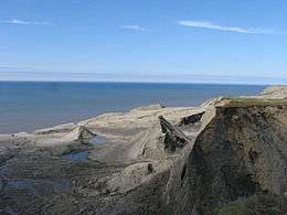 Kolguyev Island. Coastal landscape. |
_(14595270719).jpg) A reindeer herd in Kolguyev Island in 1895. The caption reads: "We entered today on a new phase of reindeer life. For the first time the fly appeared (Hypoderma tarandi), known to the Samoyeds as Pi-liur, and to the Russians as Orwot.. |
References
- GoogleEarth - Location
- "Climate of Kolguyev Island" (in Russian). Weather and Climate (Погода и климат). Retrieved 2 November 2019.
- Trevor-Battye, Aubyn. (1895). Ice-bound on Kolguev, Constable, London, 1895.
- Trevor-Battye, Aubyn. (1898). A Northern Highway of The Tsar, Constable, London, 1898.